
| Memorials | : | 0 |
| Location | : | Pendleton, Umatilla County, USA |
| Coordinate | : | 45.6743000, -118.7917000 |
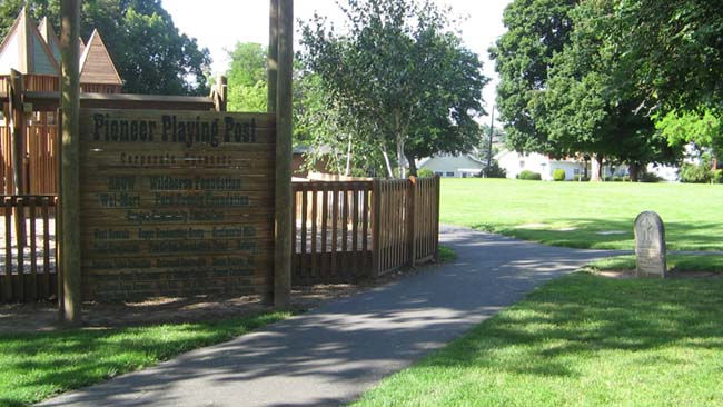
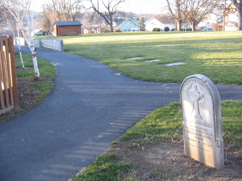
| Description | : | Land on Pendleton's north hill was donated in the 1870's by Moses and Aura Goodwin for a small cemetery. When Olney cemetery opened on the south side of town in 1891, most of the graves were relocated there and the land turned into a park. Since permission of family members were needed in order to move the graves, several graves could not be moved and still remain within the park. At least three of these graves, only the 'base' of the headstones remain, with nothing left to identify the graves. The photo shows a "Fort playground" built on adjoining land... Read More |
frequently asked questions (FAQ):
-
Where is Pioneer Park Cemetery?
Pioneer Park Cemetery is located at Pendleton, Umatilla County ,Oregon ,USA.
-
Pioneer Park Cemetery cemetery's updated grave count on graveviews.com?
0 memorials
-
Where are the coordinates of the Pioneer Park Cemetery?
Latitude: 45.6743000
Longitude: -118.7917000
Nearby Cemetories:
1. Olney Cemetery
Pendleton, Umatilla County, USA
Coordinate: 45.6589012, -118.8031006
2. Eastern Oregon State Hospital Cemetery
Pendleton, Umatilla County, USA
Coordinate: 45.6719700, -118.8179500
3. Old Agency Cemetery
Mission, Umatilla County, USA
Coordinate: 45.6678009, -118.6988983
4. Tutuilla Presbyterian Indian Mission Cemetery
Pendleton, Umatilla County, USA
Coordinate: 45.6296997, -118.7153015
5. Agency Indian Cemetery
Mission, Umatilla County, USA
Coordinate: 45.6638985, -118.6686020
6. Skyview Memorial Park
Pendleton, Umatilla County, USA
Coordinate: 45.5797005, -118.7949982
7. Pond Cemetery
Umatilla County, USA
Coordinate: 45.5773700, -118.7832900
8. Despain Gulch Cemetery
Umatilla County, USA
Coordinate: 45.7611008, -118.9124985
9. Saint Andrews Mission Cemetery
Umatilla County, USA
Coordinate: 45.6352997, -118.6241989
10. German Cemetery
Umatilla County, USA
Coordinate: 45.7916985, -118.7125015
11. Finland Cemetery
Umatilla County, USA
Coordinate: 45.7832985, -118.6628036
12. Greasewood Cemetery
Helix, Umatilla County, USA
Coordinate: 45.7904000, -118.6425000
13. Hanna Family Cemetery
Adams, Umatilla County, USA
Coordinate: 45.8002014, -118.6101990
14. Homly Cemetery
Umatilla County, USA
Coordinate: 45.6856003, -118.5192032
15. Helix Cemetery
Helix, Umatilla County, USA
Coordinate: 45.8422012, -118.6517029
16. Pilot Rock Cemetery
Pilot Rock, Umatilla County, USA
Coordinate: 45.4674988, -118.8386002
17. Nolin Cemetery
Umatilla County, USA
Coordinate: 45.6833000, -119.1027985
18. Holdman Cemetery
Holdman, Umatilla County, USA
Coordinate: 45.8744011, -118.9443970
19. Athena Cemetery
Athena, Umatilla County, USA
Coordinate: 45.8189011, -118.5030975
20. Red Elk Cemetery
Umatilla County, USA
Coordinate: 45.6796989, -118.4319000
21. Stanfield Hutterite Cemetery
Stanfield, Umatilla County, USA
Coordinate: 45.8271307, -119.0798728
22. Blue Mountain Cemetery
Weston, Umatilla County, USA
Coordinate: 45.7971992, -118.4441986
23. Koontz Gravesite
Umatilla County, USA
Coordinate: 45.7365700, -119.1880000
24. Echo Memorial Cemetery
Echo, Umatilla County, USA
Coordinate: 45.7472000, -119.1931000