
| Memorials | : | 0 |
| Location | : | Canton, Stark County, USA |
| Coordinate | : | 40.7961380, -81.3798090 |
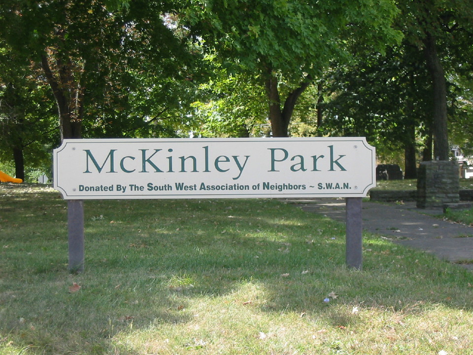
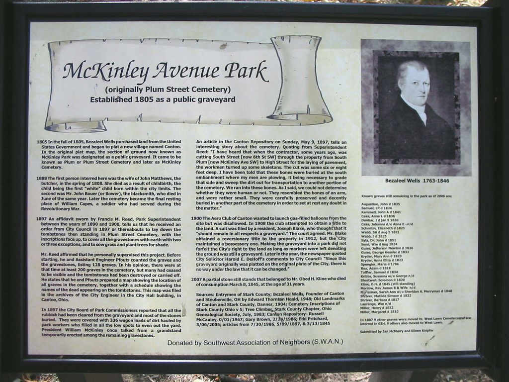
| Description | : | 1805: Canton, Ohio's first public graveyard was known as Plum Street Cemetery, located along Plum Street (now McKinley Avenue) and South Street (now 5th Street South). 1897: As Canton grew, the need for city property increased. Canton converted Plum Street Cemetery into a city park. There were an estimated 200 graves at the time. A few were moved, but most were covered with dirt, trees were planted and McKinley Park, aka McKinley Park Cemetery, replaced Plum Street Cemetery. The cemetery is located in Canton Township, Stark County, Ohio, and is listed as #11281 (McKinley Park Cemetery / Myers... Read More |
frequently asked questions (FAQ):
-
Where is Plum Street Cemetery?
Plum Street Cemetery is located at McKinley Ave SW, between 5th and 6th St SW Canton, Stark County ,Ohio , 44707USA.
-
Plum Street Cemetery cemetery's updated grave count on graveviews.com?
0 memorials
-
Where are the coordinates of the Plum Street Cemetery?
Latitude: 40.7961380
Longitude: -81.3798090
Nearby Cemetories:
1. West Lawn Cemetery
Canton, Stark County, USA
Coordinate: 40.8046640, -81.3948940
2. McKinley Memorial Park
Canton, Stark County, USA
Coordinate: 40.8073600, -81.3931910
3. Rowland Cemetery
Canton, Stark County, USA
Coordinate: 40.7930984, -81.3533020
4. Saint Johns Cemetery
Canton, Stark County, USA
Coordinate: 40.8199997, -81.3846970
5. Saint Peters Cemetery
Canton, Stark County, USA
Coordinate: 40.8205986, -81.3796997
6. Canton Hebrew Cemetery
Canton, Stark County, USA
Coordinate: 40.7722015, -81.3716965
7. Stark County Infirmary Cemetery (Defunct)
Plain Township, Stark County, USA
Coordinate: 40.8283450, -81.3859340
8. Hillcrest Cemetery
Canton, Stark County, USA
Coordinate: 40.7512880, -81.3828120
9. Valley Chapel Cemetery
Canton, Stark County, USA
Coordinate: 40.8047218, -81.3202744
10. Sancta Clara Monastery Cemetery
Canton, Stark County, USA
Coordinate: 40.8450430, -81.3642880
11. Forest Hill Cemetery
Canton, Stark County, USA
Coordinate: 40.8492966, -81.3895340
12. Saint Marks Episcopal Church Columbarium
Canton, Stark County, USA
Coordinate: 40.8524920, -81.3729960
13. Niesz Cemetery
Canton, Stark County, USA
Coordinate: 40.7515320, -81.4276610
14. North Lawn Cemetery
Canton, Stark County, USA
Coordinate: 40.8521996, -81.4002991
15. Mount Zion Cemetery
Canton, Stark County, USA
Coordinate: 40.7419879, -81.3415546
16. Saint Stephen Martyr Lutheran Church Columbarium
Canton, Stark County, USA
Coordinate: 40.8425590, -81.4358970
17. Evergreen Memorial Gardens
Louisville, Stark County, USA
Coordinate: 40.8156013, -81.2977982
18. Calvary Cemetery
Massillon, Stark County, USA
Coordinate: 40.7896996, -81.4692001
19. Mount Pleasant Cemetery
Canton, Stark County, USA
Coordinate: 40.8460007, -81.3180008
20. Gerber Cemetery
Canton, Stark County, USA
Coordinate: 40.7369440, -81.4269440
21. Fairhope Cemetery
East Canton, Stark County, USA
Coordinate: 40.8289500, -81.2984400
22. Union Cemetery
East Canton, Stark County, USA
Coordinate: 40.7839088, -81.2878036
23. Kountze Memorial Cemetery
Canton, Stark County, USA
Coordinate: 40.7847800, -81.2870500
24. Henry Warstler Cemetery
Plain Township, Stark County, USA
Coordinate: 40.8600006, -81.3332977