
| Memorials | : | 0 |
| Location | : | Vincennes, Knox County, USA |
| Coordinate | : | 38.6482500, -87.4876400 |
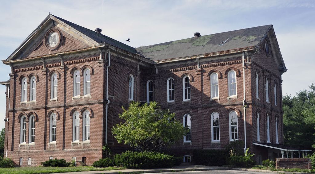
| Description | : | Poor Farm Cemetery (Potter's Field) was located about three miles east of Vincennes on South Hart Street. As early as 1800 provisions were made for keeping and burying the poor, but it was not until 1820 that initial steps were take toward the erection of a home for paupers. In 1820 General W Johnson was appointed to purchase a farm for the asylum. In 1852 a new asylum was erected, and the commissioners issued an order requiring all paupers to be sent to the asylum. In 1881 a new asylum was built to serve the people of Vincennes... Read More |
frequently asked questions (FAQ):
-
Where is Poor Farm Cemetery?
Poor Farm Cemetery is located at South Hart St Vincennes, Knox County ,Indiana , 47591USA.
-
Poor Farm Cemetery cemetery's updated grave count on graveviews.com?
0 memorials
-
Where are the coordinates of the Poor Farm Cemetery?
Latitude: 38.6482500
Longitude: -87.4876400
Nearby Cemetories:
1. Highland Cemetery
Vincennes, Knox County, USA
Coordinate: 38.6432991, -87.4880981
2. Saint Vincent dePaul Cemetery
Vincennes, Knox County, USA
Coordinate: 38.6442000, -87.4931000
3. Trinity Harbin Cemetery
Knox County, USA
Coordinate: 38.6220000, -87.4735000
4. Crown Hill Jewish Cemetery
Vincennes, Knox County, USA
Coordinate: 38.6646700, -87.5179600
5. Wildwood Cemetery
Vincennes, Knox County, USA
Coordinate: 38.6418220, -87.4456520
6. Lower Indiana Presbyterian Church Cemetery
Knox County, USA
Coordinate: 38.6418000, -87.4456000
7. Greenlawn Cemetery
Vincennes, Knox County, USA
Coordinate: 38.6669100, -87.5339200
8. Fairview Cemetery
Vincennes, Knox County, USA
Coordinate: 38.6671982, -87.5355988
9. Memorial Park Cemetery
Vincennes, Knox County, USA
Coordinate: 38.6652985, -87.5374985
10. Mount Calvary Cemetery
Vincennes, Knox County, USA
Coordinate: 38.6702995, -87.5374985
11. Saint Francis Xavier Cathedral Cemetery
Vincennes, Knox County, USA
Coordinate: 38.6791000, -87.5345000
12. Jordan-Gilmore Cemetery
Knox County, USA
Coordinate: 38.6417000, -87.4242000
13. Alton Cemetery
Knox County, USA
Coordinate: 38.6716995, -87.4244003
14. Slow Cemetery
Harrison Township, Knox County, USA
Coordinate: 38.5957985, -87.4555969
15. Palmyra Church Cemetery
Knox County, USA
Coordinate: 38.6768000, -87.4164000
16. Herman Church Cemetery
Iona, Knox County, USA
Coordinate: 38.6101000, -87.4241000
17. Catt Hill Cemetery
Knox County, USA
Coordinate: 38.5860930, -87.5106110
18. Upper Indiana Cemetery
Bruceville, Knox County, USA
Coordinate: 38.7099991, -87.4591980
19. West Salem Cemetery
Knox County, USA
Coordinate: 38.5792007, -87.4969025
20. Saint Peter Lutheran Cemetery
Vincennes, Knox County, USA
Coordinate: 38.5755997, -87.5000000
21. Fort Knox Cemetery
Vincennes, Knox County, USA
Coordinate: 38.7219018, -87.5065274
22. Purcell Store Cemetery
Decker, Knox County, USA
Coordinate: 38.5797020, -87.5273430
23. German Evangelical Cemetery
Freelandville, Knox County, USA
Coordinate: 38.5717000, -87.4726000
24. McCoy Cemetery #2
Monroe City, Knox County, USA
Coordinate: 38.6073000, -87.4018000