
| Memorials | : | 6 |
| Location | : | Sentinel, Washita County, USA |
| Coordinate | : | 35.2033005, -99.2985992 |
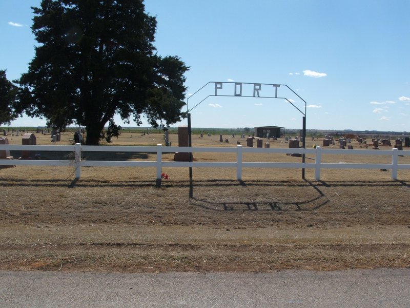
| Description | : | Located in South Elk Township; Legal description: NW ¼ Section 3, Township 11 N, Range 20 W. From Sentinel, Ok, 3 miles north on Hwy 44, then seven miles west. The town of Port existed from 1901 to 1940 and on May 11, 1928, Ruben Taylor deeded farmland to the Trustees of the Port Cemetery. The first burial in the cemetery was in 1892. Caretakers: Clifford Colwell and Keith Wilson |
frequently asked questions (FAQ):
-
Where is Port Cemetery?
Port Cemetery is located at Sentinel, Washita County ,Oklahoma ,USA.
-
Port Cemetery cemetery's updated grave count on graveviews.com?
3 memorials
-
Where are the coordinates of the Port Cemetery?
Latitude: 35.2033005
Longitude: -99.2985992
Nearby Cemetories:
1. Clark Cemetery
Sentinel, Washita County, USA
Coordinate: 35.2481003, -99.3380966
2. Retrop Cemetery
Retrop, Washita County, USA
Coordinate: 35.1405983, -99.3416977
3. Poarch Cemetery
Carter, Beckham County, USA
Coordinate: 35.2050018, -99.3985977
4. Huckaby Cemetery
Sentinel, Washita County, USA
Coordinate: 35.1557999, -99.2016983
5. Sentinel Cemetery
Sentinel, Washita County, USA
Coordinate: 35.1758003, -99.1847000
6. Ural Cemetery
Beckham County, USA
Coordinate: 35.3053017, -99.3824997
7. South Burns Cemetery
Dill City, Washita County, USA
Coordinate: 35.2625008, -99.1603012
8. Liberty Bell Cemetery
Dill City, Washita County, USA
Coordinate: 35.2331009, -99.1168976
9. North Burns Cemetery
Burns Flat, Washita County, USA
Coordinate: 35.3196983, -99.1785965
10. Pleasant Ridge Cemetery
Kiowa County, USA
Coordinate: 35.1086006, -99.1299973
11. Pleasant Valley Cemetery
Greer County, USA
Coordinate: 35.0736008, -99.4319000
12. Sand Hill Cemetery
Lake Creek, Greer County, USA
Coordinate: 35.0736100, -99.4322200
13. Bellview Cemetery
Beckham County, USA
Coordinate: 35.3060989, -99.4708023
14. Carter Cemetery
Carter, Beckham County, USA
Coordinate: 35.2324982, -99.5183029
15. Hebron Cemetery
Canute, Washita County, USA
Coordinate: 35.3849983, -99.3099976
16. Grissom Cemetery
Rocky, Washita County, USA
Coordinate: 35.1822014, -99.0772018
17. Corinth Cemetery
Burns Flat, Washita County, USA
Coordinate: 35.3636017, -99.1789017
18. Dugford Cemetery
Dill City, Washita County, USA
Coordinate: 35.2817001, -99.0821991
19. Saint Francis Cemetery
Canute, Washita County, USA
Coordinate: 35.3926811, -99.2461929
20. Lone Star Cemetery
Rocky, Washita County, USA
Coordinate: 35.1883011, -99.0594025
21. Boggy Cemetery
Burns Flat, Washita County, USA
Coordinate: 35.3485985, -99.1339035
22. Red Bluff Cemetery
Burns Flat, Washita County, USA
Coordinate: 35.3356438, -99.1006317
23. Page Cemetery
Burns Flat, Washita County, USA
Coordinate: 35.3925018, -99.1853027
24. Evergreen Cemetery
Beckham County, USA
Coordinate: 35.4017180, -99.3997870