
| Memorials | : | 0 |
| Location | : | Cochise County, USA |
| Coordinate | : | 31.7497510, -110.2042780 |
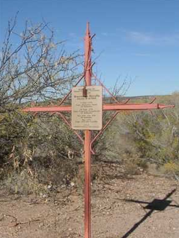
| Description | : | Cross & marker erected by Warrant Officers of Fort Huahuca for 98 persons killed in action at this Spanish Fort. On July 7, 1776 a battle left Capt. Tovar & twenty-nine of his soldiers dead. On Sept 24, 1778 a battle left Capt. Trespalacios & twenty-seven soldiers dead. Between Nov. 1778 and Feb. 1779 another 39 soldiers were killed-in-action. During May 1779 Capt. Luis del Castillo was killed-in-action. Location: Take I-10 east from Tucson to AZ 90. Go south 20 miles to AZ 82. Go east 9 miles to Kellar Road, then 2 miles north to the parking lot. It is... Read More |
frequently asked questions (FAQ):
-
Where is Presidio of Santa Cruz de Terrenate Cemetery?
Presidio of Santa Cruz de Terrenate Cemetery is located at Cochise County ,Arizona ,USA.
-
Presidio of Santa Cruz de Terrenate Cemetery cemetery's updated grave count on graveviews.com?
0 memorials
-
Where are the coordinates of the Presidio of Santa Cruz de Terrenate Cemetery?
Latitude: 31.7497510
Longitude: -110.2042780
Nearby Cemetories:
1. Contention City Cemetery
Cochise County, USA
Coordinate: 31.7696750, -110.2017680
2. Fairbank Cemetery
Fairbank, Cochise County, USA
Coordinate: 31.7297000, -110.1867000
3. Schieffelin Gravesite
Cochise County, USA
Coordinate: 31.7307500, -110.1034000
4. Tombstone Cemetery New Addition
Tombstone, Cochise County, USA
Coordinate: 31.7184391, -110.0813675
5. Tombstone Cemetery
Tombstone, Cochise County, USA
Coordinate: 31.7168407, -110.0783234
6. Charleston Cemetery
Cochise County, USA
Coordinate: 31.6357260, -110.1775570
7. Saint David Cemetery
Saint David, Cochise County, USA
Coordinate: 31.8663998, -110.2050018
8. Boothill Graveyard
Tombstone, Cochise County, USA
Coordinate: 31.7203900, -110.0703000
9. Brunckow's Cabin
Cochise County, USA
Coordinate: 31.6385120, -110.1575450
10. Holy Trinity Monastary Cemetery
Saint David, Cochise County, USA
Coordinate: 31.8769000, -110.2136000
11. Campstone Cemetery
Huachuca City, Cochise County, USA
Coordinate: 31.6433000, -110.3480000
12. Cochise Memory Gardens
Sierra Vista, Cochise County, USA
Coordinate: 31.5698000, -110.2283000
13. Sierra Evangelical Lutheran Church Columbarium
Sierra Vista, Cochise County, USA
Coordinate: 31.5562140, -110.2816090
14. Saint Andrew the Apostle Memorial Garden
Sierra Vista, Cochise County, USA
Coordinate: 31.5628800, -110.3019300
15. Fry Cemetery
Sierra Vista, Cochise County, USA
Coordinate: 31.5560800, -110.2918700
16. Cochise Gardens of Rest Cemetery
Benson, Cochise County, USA
Coordinate: 31.9493999, -110.2906036
17. Saint Stephens Episcopal Church Columbarium
Sierra Vista, Cochise County, USA
Coordinate: 31.5409760, -110.2711270
18. Holy Hope Cemetery
Sierra Vista, Cochise County, USA
Coordinate: 31.5297450, -110.2025000
19. San Pedro Valley UMC Columbarium
Benson, Cochise County, USA
Coordinate: 31.9631020, -110.2894510
20. Southern Arizona Veterans Memorial Cemetery
Sierra Vista, Cochise County, USA
Coordinate: 31.5399380, -110.3007278
21. Historic Cemetery of the Southern Arizona Veterans
Sierra Vista, Cochise County, USA
Coordinate: 31.5411000, -110.3050000
22. High Street Cemetery
Benson, Cochise County, USA
Coordinate: 31.9591999, -110.3047028
23. Seventh Street Cemetery
Benson, Cochise County, USA
Coordinate: 31.9642300, -110.2934100
24. Sierra Vista United Methodist Church Columbarium
Sierra Vista, Cochise County, USA
Coordinate: 31.5104180, -110.2651550