
| Memorials | : | 45 |
| Location | : | Floyd, Floyd County, USA |
| Coordinate | : | 36.9389190, -80.1848500 |
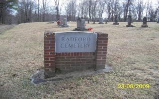
| Description | : | The Radford Cemetery is just off the Blue Ridge Parkway on Route 888. It is the newer of two Radford cemeteries, the older cemetery being 3/4 miles on down Route 888 back in the woods. From Roanoke, Va. Area: About 33 Miles south from US-220 on Blue Ridge Parkway near BRP MP #155 just north of the SMART VIEW Overlook area.. Turn west on Rt.993 Remington Rd. (dirt road), then immediate left on Rt. 888 Silverleaf Rd.(parallels west side of BRP). Radford Family Cemetery is about 0.2 mile down Rt. 888 on right/west side of road. From Floyd, Va., take US-221... Read More |
frequently asked questions (FAQ):
-
Where is Radford Cemetery?
Radford Cemetery is located at Silverleaf Road SE (Rt. 888) Floyd, Floyd County ,Virginia , 24091USA.
-
Radford Cemetery cemetery's updated grave count on graveviews.com?
45 memorials
-
Where are the coordinates of the Radford Cemetery?
Latitude: 36.9389190
Longitude: -80.1848500
Nearby Cemetories:
1. Gillespie Cemetery
Floyd, Floyd County, USA
Coordinate: 36.9389229, -80.1848935
2. West Cemetery
Smart, Floyd County, USA
Coordinate: 36.9365630, -80.1976930
3. Beckner Cemetery #2
Floyd County, USA
Coordinate: 36.9517870, -80.1855830
4. Peters Family Cemetery
Floyd, Floyd County, USA
Coordinate: 36.9578403, -80.1854498
5. Cannaday Cemetery
Floyd, Floyd County, USA
Coordinate: 36.9255980, -80.2040820
6. Yeatts Cemetery
Pizarro, Floyd County, USA
Coordinate: 36.9389000, -80.2199000
7. Underwood Cemetery
Floyd, Floyd County, USA
Coordinate: 36.9128780, -80.2031780
8. Elkanah Thompson Cemetery
Pizarro, Floyd County, USA
Coordinate: 36.9580790, -80.1558260
9. Pate - Peters Cemetery
Floyd, Floyd County, USA
Coordinate: 36.9515055, -80.1481130
10. Kelley-Peters Family Cemetery
Floyd, Floyd County, USA
Coordinate: 36.9624822, -80.1560159
11. Sweeney Cemetery
Floyd, Floyd County, USA
Coordinate: 36.9509640, -80.2243460
12. Little River Cemetery
Pizarro, Floyd County, USA
Coordinate: 36.9520520, -80.2252900
13. Stephen Board Cemetery
Floyd, Floyd County, USA
Coordinate: 36.9745816, -80.1865791
14. Kelley-Ingram Cemetery
Smart, Floyd County, USA
Coordinate: 36.9727850, -80.1616730
15. Akers Family Cemetery
Floyd, Floyd County, USA
Coordinate: 36.9760752, -80.1678365
16. Brammer Cemetery
Floyd, Floyd County, USA
Coordinate: 36.9163984, -80.2261629
17. Claytor Family Cemetery
Copper Hill, Floyd County, USA
Coordinate: 36.9736138, -80.2123514
18. Harvestwood Cemetery
Floyd, Floyd County, USA
Coordinate: 36.9277955, -80.2352426
19. Cannaday Family Cemetery
Copper Hill, Floyd County, USA
Coordinate: 36.9800640, -80.1745970
20. Floyd County Farm Cemetery
Floyd, Floyd County, USA
Coordinate: 36.9606960, -80.2320990
21. Price Cemetery
Floyd, Floyd County, USA
Coordinate: 36.9813493, -80.1995809
22. Wright Cemetery
Pizarro, Floyd County, USA
Coordinate: 36.9765820, -80.2169300
23. Graham Cemetery
Pizarro, Floyd County, USA
Coordinate: 36.9172780, -80.2387120
24. John Huff Cemetery
Callaway, Franklin County, USA
Coordinate: 36.9704815, -80.1385909