
| Memorials | : | 12 |
| Location | : | Ralls, Crosby County, USA |
| Coordinate | : | 33.6732521, -101.4008408 |
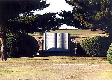
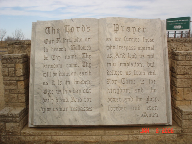
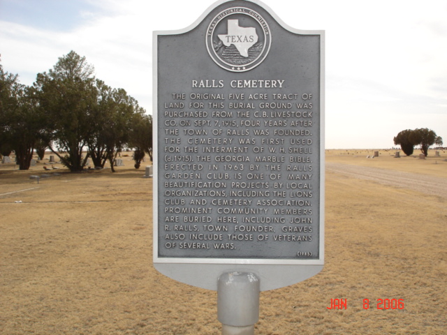
| Description | : | Location: The Ralls Cemetery is a large cemetery that is located outside and to the southwest of the town of Ralls. From Ralls, take Highway 82 about .7 miles West (.7 mile West of SH207). The original five acre tract of land for this burial ground was purchased from the C.B. Livestock Co. on September 7, 1915, four years after the town of Ralls was founded. The cemetery was first used for the interment of W.H. Shell (d. 1915). The Georgia marble Bible, erected in 1963 by the Ralls Garden Club, is one of many beautification projects... Read More |
frequently asked questions (FAQ):
-
Where is Ralls Cemetery?
Ralls Cemetery is located at TX 114 / Hwy 82 Ralls, Crosby County ,Texas , 79357USA.
-
Ralls Cemetery cemetery's updated grave count on graveviews.com?
12 memorials
-
Where are the coordinates of the Ralls Cemetery?
Latitude: 33.6732521
Longitude: -101.4008408
Nearby Cemetories:
1. Emma Cemetery
Crosby County, USA
Coordinate: 33.6114970, -101.4123950
2. Lorenzo Cemetery
Lorenzo, Crosby County, USA
Coordinate: 33.6958008, -101.5355988
3. Cone Cemetery
Cone, Crosby County, USA
Coordinate: 33.7971992, -101.4216995
4. West Side Cemetery
Lorenzo, Crosby County, USA
Coordinate: 33.6678009, -101.5603027
5. Crosbyton Cemetery
Crosbyton, Crosby County, USA
Coordinate: 33.6577988, -101.2099991
6. Mount Zion Cemetery
Crosby County, USA
Coordinate: 33.6533700, -101.1922100
7. Rock House Cemetery
Mount Blanco, Crosby County, USA
Coordinate: 33.8016080, -101.2487020
8. Lakeview Cemetery
Floyd County, USA
Coordinate: 33.8741989, -101.2577972
9. Petersburg Cemetery
Petersburg, Hale County, USA
Coordinate: 33.8687850, -101.5832380
10. Carrs Chapel Cemetery
Allmon, Floyd County, USA
Coordinate: 33.9262695, -101.5125580
11. Antelope Cemetery
Floyd County, USA
Coordinate: 33.8692017, -101.0980988
12. McAdoo Cemetery
McAdoo, Dickens County, USA
Coordinate: 33.7252998, -101.0214005
13. Forest Lawn Cemetery
Floydada, Floyd County, USA
Coordinate: 33.9752600, -101.2729840
14. Floyd County Memorial Park
Floydada, Floyd County, USA
Coordinate: 34.0031600, -101.3262000
15. Floydada Cemetery
Floydada, Floyd County, USA
Coordinate: 34.0058000, -101.3265300
16. Resthaven Cemetery
Southland, Garza County, USA
Coordinate: 33.3527985, -101.5541992
17. Strip Cemetery
Hale County, USA
Coordinate: 33.8553009, -101.7724991
18. Dougherty Cemetery
Dougherty, Floyd County, USA
Coordinate: 33.9503070, -101.0851670
19. Della Plain Cemetery
Floydada, Floyd County, USA
Coordinate: 34.0674460, -101.3217040
20. Rushing Chapel Cemetery
Floyd County, USA
Coordinate: 34.0558014, -101.2202988
21. Red Mud Cemetery
Spur, Dickens County, USA
Coordinate: 33.4265120, -100.9987710
22. Abernathy Cemetery
Abernathy, Hale County, USA
Coordinate: 33.8474180, -101.8628530
23. Irick Cemetery
Aiken, Floyd County, USA
Coordinate: 34.0884300, -101.5083090
24. Espuela Cemetery
Dickens County, USA
Coordinate: 33.5750008, -100.8949966