
| Memorials | : | 0 |
| Location | : | Cricqueville-en-Bessin, Departement du Calvados, France |
| Coordinate | : | 49.3971960, -0.9892920 |
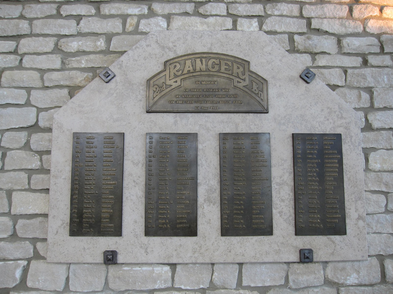
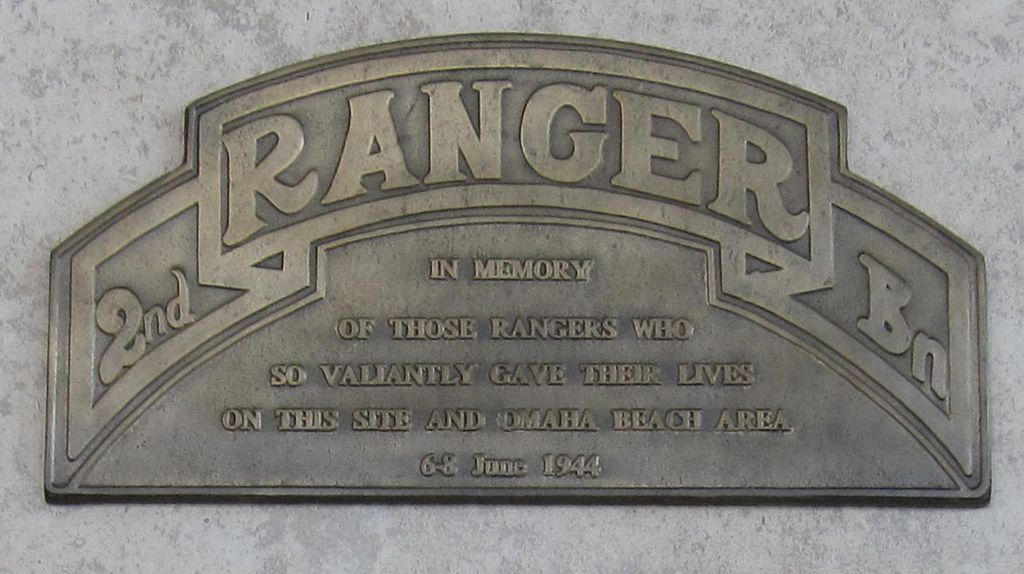
| Description | : | The World War II Pointe du Hoc Ranger Monument is located on a cliff eight miles west of Normandy American Cemetery and Memorial, which overlooks Omaha Beach. It was erected by the French to honor elements of the American Second Ranger Battalion under the command of Lieutenant Colonel James E. Rudder. During the American assault of Omaha Beach on June 6, 1944, these elements scaled the 100-foot cliff and seized the German artillery pieces that could have fired on the American landing troops at Omaha Beach. At a high cost of life, they successfully defended against determined... Read More |
frequently asked questions (FAQ):
-
Where is Rangers Memorial?
Rangers Memorial is located at Cricqueville-en-Bessin, Departement du Calvados ,Basse-Normandie ,France.
-
Rangers Memorial cemetery's updated grave count on graveviews.com?
0 memorials
-
Where are the coordinates of the Rangers Memorial?
Latitude: 49.3971960
Longitude: -0.9892920
Nearby Cemetories:
1. Grandcamp-les-Bains Churchyard
Grandcamp-Maisy, Departement du Calvados, France
Coordinate: 49.3884544, -1.0320394
2. Englesqueville-la-percée
Englesqueville-la-Percee, Departement du Calvados, France
Coordinate: 49.3762275, -0.9529657
3. La Cambe German Military Cemetery
La Cambe, Departement du Calvados, France
Coordinate: 49.3419266, -1.0265590
4. Normandy American Cemetery and Memorial
Colleville-sur-Mer, Departement du Calvados, France
Coordinate: 49.3603249, -0.8580490
5. Brevands Churchyard
Brevands, Departement de la Manche, France
Coordinate: 49.3315324, -1.1902880
6. Saint-Martin de Maisons
Maisons, Departement du Calvados, France
Coordinate: 49.3144388, -0.7494404
7. Saint-André de Cottun
Cottun, Departement du Calvados, France
Coordinate: 49.2720334, -0.7915038
8. Saint-Barthélemy de Cussy
Cussy, Departement du Calvados, France
Coordinate: 49.2845119, -0.7639027
9. Airel Churchyard
Airel, Departement de la Manche, France
Coordinate: 49.2193108, -1.0804350
10. Saint-Laurent de Matingy
Longues-sur-Mer, Departement du Calvados, France
Coordinate: 49.3354860, -0.7059486
11. Cimetière de Saint-Laurent
Longues-sur-Mer, Departement du Calvados, France
Coordinate: 49.3351965, -0.6998523
12. Saint-Martin de Barbeville
Barbeville, Departement du Calvados, France
Coordinate: 49.2777335, -0.7452292
13. Bayeux War Cemetery
Bayeux, Departement du Calvados, France
Coordinate: 49.2734500, -0.7148900
14. Bayeux Memorial
Bayeux, Departement du Calvados, France
Coordinate: 49.2744572, -0.7136136
15. Bayeux Cathedral
Bayeux, Departement du Calvados, France
Coordinate: 49.2756300, -0.7032500
16. Bayeux Eastern Cemetery
Bayeux, Departement du Calvados, France
Coordinate: 49.2728500, -0.6882100
17. Amfreville
Amfreville, Departement de la Manche, France
Coordinate: 49.4104758, -1.3921995
18. Montebourg Abbey
Montebourg, Departement de la Manche, France
Coordinate: 49.4912111, -1.3735592
19. Ryes War Cemetery
Bazenville, Departement du Calvados, France
Coordinate: 49.3001800, -0.6008400
20. Mondaye Abbaye de St. Martin
Juaye-Mondaye, Departement du Calvados, France
Coordinate: 49.2065350, -0.6877410
21. Cimetière Communal de Saint-Lô
Saint-Lô, Departement de la Manche, France
Coordinate: 49.1171760, -1.0829500
22. Jerusalem War Cemetery
Chouain, Departement du Calvados, France
Coordinate: 49.2099100, -0.6521000
23. Église Notre-Dame de Saint-Lô
Saint-Lô, Departement de la Manche, France
Coordinate: 49.1153000, -1.0942000
24. Kriegsgräberstätte in Orglandes
Orglandes, Departement de la Manche, France
Coordinate: 49.4254480, -1.4483590