
| Memorials | : | 0 |
| Location | : | Aroma Park, Kankakee County, USA |
| Coordinate | : | 41.0923380, -87.7830260 |
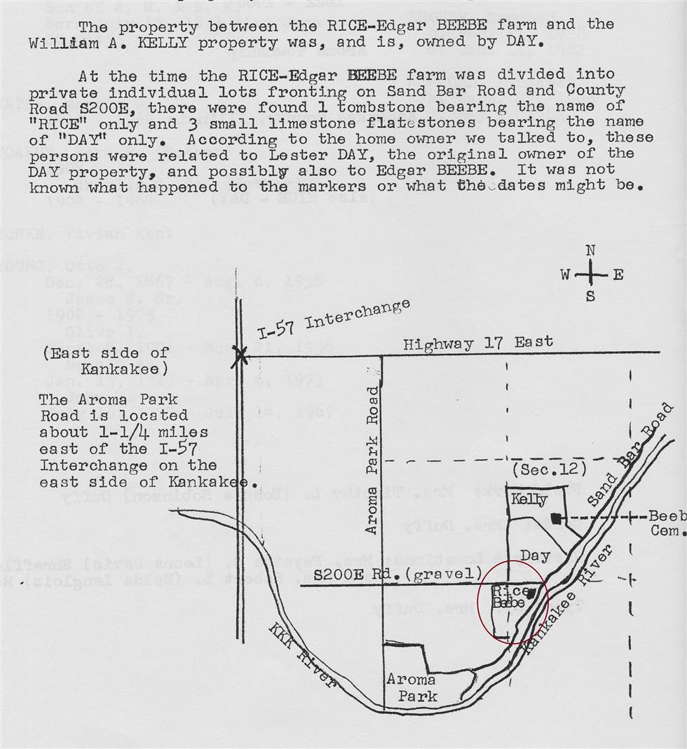
| Description | : | According to the Aroma Park plat map printed in 1883, this small family cemetery is located on Sandbar Road and County Road S200E (Day Road). According to the Southeast Section Cemetery Book published in 1983 by the KVGS, at the time the Rice-Edgar Beebe farm was divided into private individual lots, there was one Rice marker found and 3 small limestone flat stones bearing the name of Day. This cemetery sits on the northernmost tip of Jonathan and Susan Rice's farmland and near the original location of their house. The graves located here are believed to be the graves of Jonathan... Read More |
frequently asked questions (FAQ):
-
Where is Rice-Day Family Cemetery?
Rice-Day Family Cemetery is located at Aroma Park, Kankakee County ,Illinois ,USA.
-
Rice-Day Family Cemetery cemetery's updated grave count on graveviews.com?
0 memorials
-
Where are the coordinates of the Rice-Day Family Cemetery?
Latitude: 41.0923380
Longitude: -87.7830260
Nearby Cemetories:
1. Beebe Family Cemetery
Aroma Park, Kankakee County, USA
Coordinate: 41.0980873, -87.7822647
2. Aroma Park Cemetery
Aroma Park, Kankakee County, USA
Coordinate: 41.0801773, -87.7962036
3. Leggtown Cemetery
Aroma Township, Kankakee County, USA
Coordinate: 41.0814018, -87.7600021
4. Mount Langham Cemetery
Aroma Park, Kankakee County, USA
Coordinate: 41.0632700, -87.7733600
5. Bnai Israel Cemetery
Kankakee County, USA
Coordinate: 41.1189003, -87.8088989
6. Kankakee Memorial Gardens and Chapel Mausoleum
Kankakee, Kankakee County, USA
Coordinate: 41.1189613, -87.8116989
7. State Hospital Cemetery
Aroma Park, Kankakee County, USA
Coordinate: 41.0952988, -87.8416977
8. Mount Calvary Cemetery and Mausoleum
Kankakee, Kankakee County, USA
Coordinate: 41.1188545, -87.8363113
9. Saint Paul's Episcopal Columbarium
Kankakee, Kankakee County, USA
Coordinate: 41.1175300, -87.8597100
10. Saint Rose Cemetery
Kankakee, Kankakee County, USA
Coordinate: 41.1330910, -87.8497314
11. Mound Grove Cemetery
Kankakee, Kankakee County, USA
Coordinate: 41.1321983, -87.8527985
12. Oakwood Cemetery
Wichert, Kankakee County, USA
Coordinate: 41.0647011, -87.6896973
13. Old Baptist Cemetery
Kankakee County, USA
Coordinate: 41.0427000, -87.7062600
14. Saint Anne Catholic Cemetery
Saint Anne, Kankakee County, USA
Coordinate: 41.0264015, -87.7311020
15. Saint Anne Township Cemetery
Saint Anne, Kankakee County, USA
Coordinate: 41.0222015, -87.7316971
16. Van Meter Cemetery
Bradley, Kankakee County, USA
Coordinate: 41.1400430, -87.8808830
17. Barnett Cemetery
Kankakee County, USA
Coordinate: 41.0155983, -87.8399963
18. Concordia Cemetery
Wichert, Kankakee County, USA
Coordinate: 41.0553017, -87.6753006
19. Olivet Nazarene University Columbarium
Bourbonnais, Kankakee County, USA
Coordinate: 41.1534950, -87.8744880
20. Mount Airy Cemetery
Momence, Kankakee County, USA
Coordinate: 41.1460991, -87.6821976
21. Maternity Blessed Virgin Mary Cemetery #01
Bourbonnais, Kankakee County, USA
Coordinate: 41.1561820, -87.8759750
22. Saint George Catholic Cemetery
Bourbonnais, Kankakee County, USA
Coordinate: 41.1913500, -87.7744800
23. Maternity Blessed Virgin Mary Cemetery #02
Bourbonnais, Kankakee County, USA
Coordinate: 41.1517230, -87.8929160
24. Momence Cemetery
Momence, Kankakee County, USA
Coordinate: 41.1768990, -87.6742020