| Memorials | : | 0 |
| Location | : | Basehor, Leavenworth County, USA |
| Coordinate | : | 39.1450770, -94.9210520 |
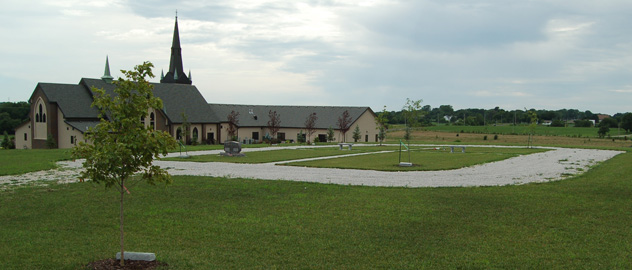
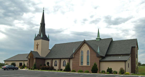
| Description | : | Risen Savior Lutheran Cemetery was dedicated February 15, 2015 and is currently in the process of being laid out on the hill behind the church. The cemetery will contain approximately 550 plots and will be enhanced wtih pathways and statuary. Risen Savior Church began in 2008 with the merger of two smaller congregations- Saint Martin's founded in 1908 and Emmaus founded in 1968. The church building completed in 2011 has many architectural and artistic features. . |
frequently asked questions (FAQ):
-
Where is Risen Savior Lutheran Cemetery?
Risen Savior Lutheran Cemetery is located at 14700 Leavenworth Road Basehor, Leavenworth County ,Kansas , 66007USA.
-
Risen Savior Lutheran Cemetery cemetery's updated grave count on graveviews.com?
0 memorials
-
Where are the coordinates of the Risen Savior Lutheran Cemetery?
Latitude: 39.1450770
Longitude: -94.9210520
Nearby Cemetories:
1. Glenwood Cemetery
Fairmount Township, Leavenworth County, USA
Coordinate: 39.1080017, -94.9449005
2. Harrods Ridge Cemetery
Fairmount, Leavenworth County, USA
Coordinate: 39.1963800, -94.9175000
3. Holy Angels Cemetery
Basehor, Leavenworth County, USA
Coordinate: 39.1460991, -94.9953003
4. Old Kelly Burial Grounds
Leavenworth, Leavenworth County, USA
Coordinate: 39.2047100, -94.9586200
5. Mary Perry Gravesite
Lansing, Leavenworth County, USA
Coordinate: 39.2211700, -94.9016700
6. Berger Burial Site
Tonganoxie, Leavenworth County, USA
Coordinate: 39.1411100, -95.0269600
7. Elm Grove Cemetery
Mahon, Leavenworth County, USA
Coordinate: 39.0582085, -94.9450150
8. Himple Cemetery
Tonganoxie, Leavenworth County, USA
Coordinate: 39.0980988, -95.0192032
9. Starns Cemetery
Lansing, Leavenworth County, USA
Coordinate: 39.2435989, -94.9488983
10. Moore-Summit Cemetery
Tonganoxie, Leavenworth County, USA
Coordinate: 39.1417440, -95.0554280
11. Cemetery of the Good Thief
Leavenworth County, USA
Coordinate: 39.2497700, -94.8962700
12. Little Stranger Cemetery
Leavenworth County, USA
Coordinate: 39.2453003, -94.9741974
13. Delaware Cemetery
Lansing, Leavenworth County, USA
Coordinate: 39.2489600, -94.8774400
14. Mount Calvary Cemetery
Leavenworth, Leavenworth County, USA
Coordinate: 39.2653008, -94.9214020
15. Boles Cemetery
Wilder, Johnson County, USA
Coordinate: 39.0292168, -94.8723450
16. Meritt Cemetery
Platte County, USA
Coordinate: 39.2168400, -94.7878800
17. Mount Muncie Cemetery
Lansing, Leavenworth County, USA
Coordinate: 39.2694016, -94.8889008
18. Sarcoxie Cemetery
Linwood, Leavenworth County, USA
Coordinate: 39.0410995, -95.0186005
19. Brown Cemetery
Platte County, USA
Coordinate: 39.2381900, -94.7990100
20. Leavenworth National Cemetery
Leavenworth, Leavenworth County, USA
Coordinate: 39.2770996, -94.8874435
21. Naylor South Cemetery
Parkville, Platte County, USA
Coordinate: 39.1964680, -94.7599020
22. Cocayne-Gray Family Cemetery
Platte County, USA
Coordinate: 39.2306200, -94.7846100
23. Mount Olivet Cemetery
Leavenworth, Leavenworth County, USA
Coordinate: 39.2811012, -94.9036026
24. Ellis Cemetery
Waldron, Platte County, USA
Coordinate: 39.2253900, -94.7781900


