
| Memorials | : | 0 |
| Location | : | Mobile, Mobile County, USA |
| Website | : | sandtowngroup.org |
| Coordinate | : | 30.7079910, -88.1425300 |
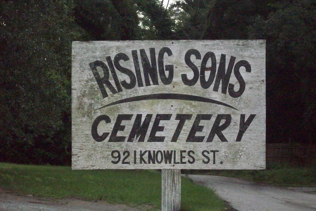
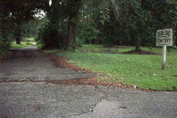
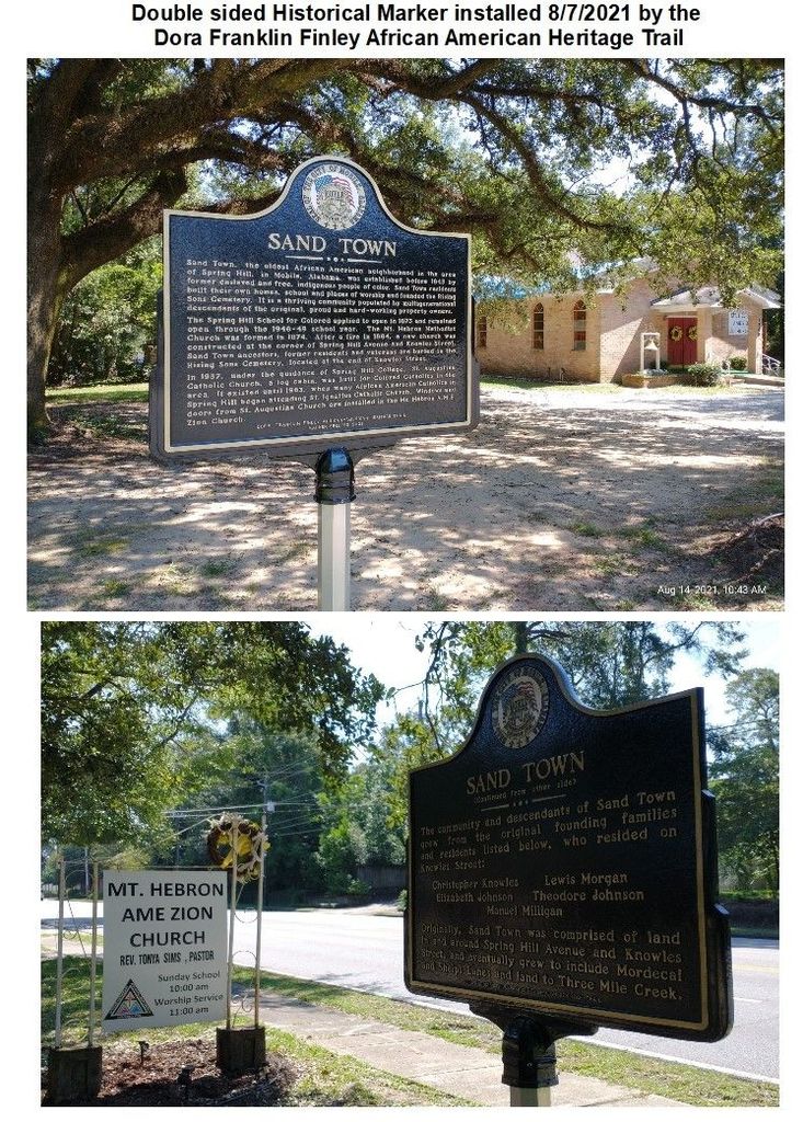
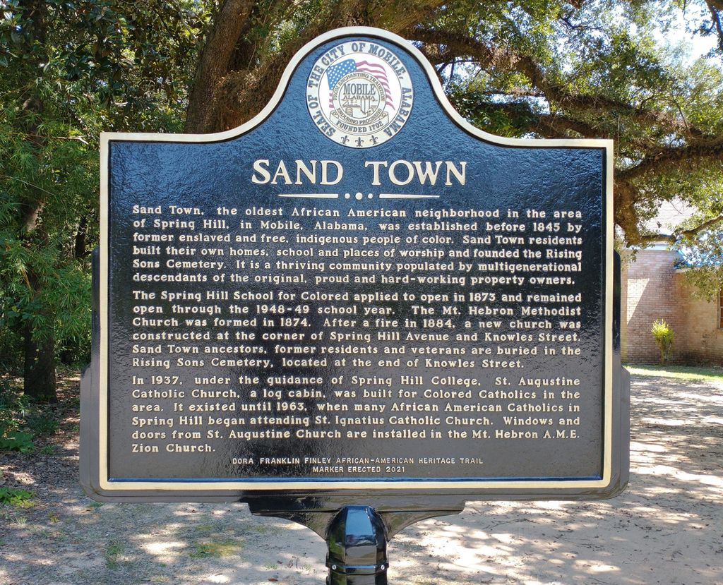
| Description | : | Sand Town is a historical residential area and the oldest African American neighborhood located in the Spring Hill community of Mobile, Alabama. Established before 1845, Sand Town predates the United States Civil War. Nearby stands a culturally significant 145 year old American landmark: a continuously functional brick church where residents hold services every Wednesday and Sunday. An adjacent cemetery (Rising Sons Cemetery) commemorates the Sand Town community ancestors. They were former slaves and free Indigenous Black Americans who created this community together. For more history see the community website. |
frequently asked questions (FAQ):
-
Where is Rising Sons Cemetery?
Rising Sons Cemetery is located at End of Denson Court off of Knowles Street Mobile, Mobile County ,Alabama , 36608USA.
-
Rising Sons Cemetery cemetery's updated grave count on graveviews.com?
0 memorials
-
Where are the coordinates of the Rising Sons Cemetery?
Latitude: 30.7079910
Longitude: -88.1425300
Nearby Cemetories:
1. Spring Hill Graveyard
Mobile, Mobile County, USA
Coordinate: 30.7014008, -88.1402969
2. Wilson Annex Cemetery
Mobile, Mobile County, USA
Coordinate: 30.7147100, -88.1321300
3. Spring Hill Catholic Cemetery
Mobile, Mobile County, USA
Coordinate: 30.6957120, -88.1361730
4. Elysian Memorial Park
Mobile, Mobile County, USA
Coordinate: 30.7219970, -88.1363230
5. Spring Hill College Jesuit Cemetery
Mobile, Mobile County, USA
Coordinate: 30.6939600, -88.1359100
6. Miller Cemetery
Mobile, Mobile County, USA
Coordinate: 30.6889700, -88.1663900
7. Wolf Ridge Cemetery
Mobile, Mobile County, USA
Coordinate: 30.7367001, -88.1346970
8. Newell Cemetery
Mobile, Mobile County, USA
Coordinate: 30.7376190, -88.1268010
9. Green Mound Cemetery
Mobile County, USA
Coordinate: 30.7119007, -88.1033020
10. Gethsemane Cemetery
Mobile, Mobile County, USA
Coordinate: 30.7155330, -88.1032920
11. Saint Edwards Cemetery
Mobile, Mobile County, USA
Coordinate: 30.6867320, -88.1819340
12. New Hope Gardens
Mobile, Mobile County, USA
Coordinate: 30.6910000, -88.1904984
13. Visitation Monastery Cemetery
Mobile, Mobile County, USA
Coordinate: 30.6940100, -88.0918400
14. Gethsemane North Cemetery
Eight Mile, Mobile County, USA
Coordinate: 30.7544136, -88.1440811
15. Whispering Pines Cemetery
Mobile, Mobile County, USA
Coordinate: 30.7560997, -88.1243973
16. Prichard Cemetery
Mobile, Mobile County, USA
Coordinate: 30.7563400, -88.1224800
17. Elam Cemetery
Mobile County, USA
Coordinate: 30.7574997, -88.1247025
18. Trinity Episcopal Church Memory Garden
Mobile, Mobile County, USA
Coordinate: 30.6867090, -88.0859700
19. Pleasant Valley United Methodist Church Cemetery
Mobile, Mobile County, USA
Coordinate: 30.6618730, -88.1091070
20. Lewis Family Cemetery
Eight Mile, Mobile County, USA
Coordinate: 30.7621900, -88.1377900
21. Vincent Chapel Cemetery
Mobile, Mobile County, USA
Coordinate: 30.7489220, -88.1844560
22. Saint Austin Cemetery
Mobile, Mobile County, USA
Coordinate: 30.7175610, -88.0800090
23. Bear Fork Road Cemetery
Mobile, Mobile County, USA
Coordinate: 30.7490300, -88.1844300
24. Whistler Cemetery
Whistler, Mobile County, USA
Coordinate: 30.7597008, -88.1172028