
| Memorials | : | 0 |
| Location | : | War Eagle, Benton County, USA |
| Coordinate | : | 36.2750000, -93.8717000 |
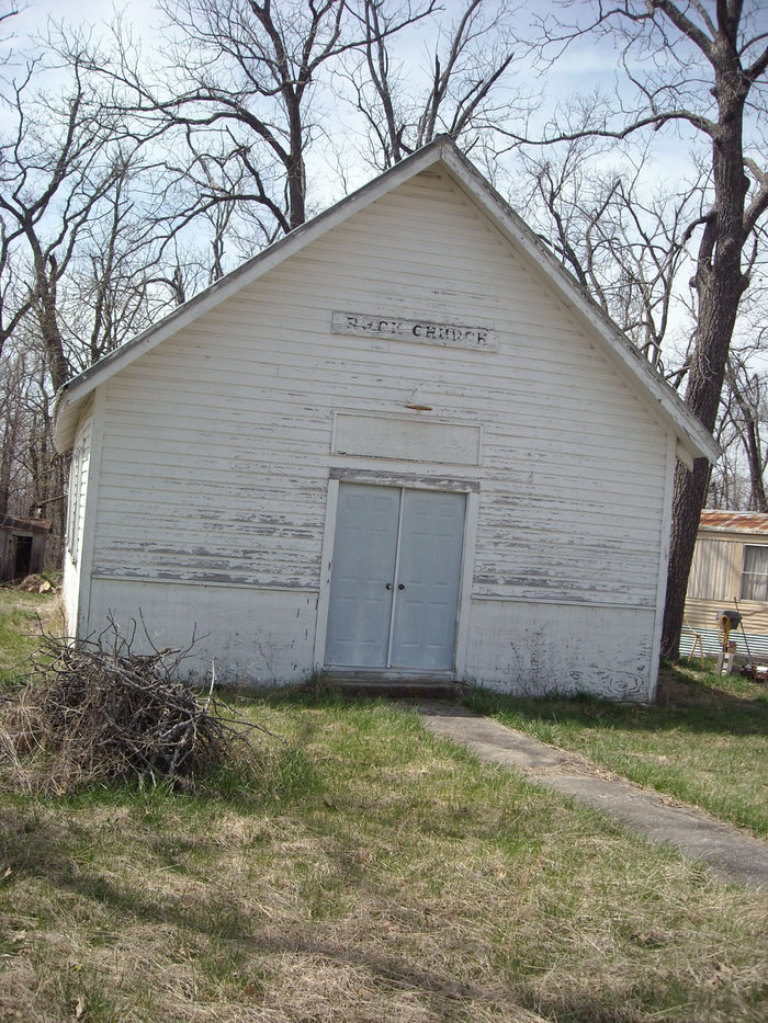
| Description | : | From Clifty, Arkansas, go north on Highway 12 to the junction with Highway 127. Turn left on Highway 127 and go approximately six miles. The old Rock Church building is right beside the road on the left. The Rock Church is located about 500 feet from the Madison County line, and is actually in Benton County. Original readings of this cemetery stated that there were two upright stones with inscriptions and one sandstone fieldrock with no inscription, located about 50 feet from the fence beside the building. It appears that the Church is now a private residence and... Read More |
frequently asked questions (FAQ):
-
Where is Rock Church Cemetery?
Rock Church Cemetery is located at War Eagle, Benton County, USA.
-
Rock Church Cemetery cemetery's updated grave count on graveviews.com?
0 memorials
-
Where are the coordinates of the Rock Church Cemetery?
Latitude: 36.2750000
Longitude: -93.8717000
Nearby Cemetories:
1. Rock Cemetery
Benton County, USA
Coordinate: 36.2743988, -93.8716965
2. Rambo Cemetery
Rogers, Benton County, USA
Coordinate: 36.3027992, -93.8741989
3. Hickory Grove Cemetery
Madison County, USA
Coordinate: 36.2433390, -93.8524250
4. Pemberton Cemetery
Madison County, USA
Coordinate: 36.2891998, -93.8266983
5. Old Best Cemetery
Benton County, USA
Coordinate: 36.2360992, -93.8850021
6. Sandstone Mountain Cemetery
Clifty, Madison County, USA
Coordinate: 36.2730400, -93.8192700
7. Austin Cemetery
Beacon Addition, Benton County, USA
Coordinate: 36.2379000, -93.9096000
8. Eden Bluff Cemetery
War Eagle, Benton County, USA
Coordinate: 36.2428460, -93.9217150
9. Burkes - Shorty Burkes Cemetery
Hindsville, Madison County, USA
Coordinate: 36.2242000, -93.8534000
10. Hatfield Cemetery
Benton County, USA
Coordinate: 36.3244019, -93.9128036
11. Carter Cemetery (Defunct)
Benton County, USA
Coordinate: 36.3325005, -93.9072037
12. War Eagle Cemetery
Rogers, Benton County, USA
Coordinate: 36.2689018, -93.9522018
13. Henson Cemetery (Defunct)
Benton County, USA
Coordinate: 36.3386002, -93.8917007
14. Lopshire Cemetery
Clifty, Madison County, USA
Coordinate: 36.2092900, -93.8620000
15. Burkshed Cemetery
Washington County, USA
Coordinate: 36.2156100, -93.9111300
16. Denny Cemetery
Madison County, USA
Coordinate: 36.2061005, -93.8822021
17. Wade Cemetery
Madison County, USA
Coordinate: 36.2041400, -93.8801600
18. Clifty Cemetery
Clifty, Madison County, USA
Coordinate: 36.2372810, -93.7951960
19. Upper Clifty Cemetery
Clifty, Madison County, USA
Coordinate: 36.2380700, -93.7929200
20. L.D. Vaughan Cemetery
Clifty, Madison County, USA
Coordinate: 36.2317800, -93.7941700
21. New Evans Cemetery
Clifty, Madison County, USA
Coordinate: 36.1935080, -93.8683680
22. Woodline Cemetery
Clifty, Madison County, USA
Coordinate: 36.2387400, -93.7792000
23. Christian Unity Church Cemetery
Eureka Springs, Carroll County, USA
Coordinate: 36.3287350, -93.7930450
24. Bettis Cemetery
Hindsville, Madison County, USA
Coordinate: 36.1861400, -93.9066000