
| Memorials | : | 0 |
| Location | : | Rockland, Knox County, USA |
| Coordinate | : | 44.1289860, -69.1266860 |
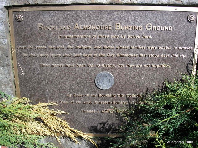
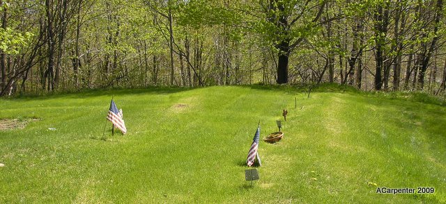
| Description | : | Also known over the years as the City Farm Cemetery, Poor Farm Cemetery and Evergreen Cemetery. Located on West Meadow Rd. near the Mill Stream. The Almshouse Poor Farm that was located next to the cemetery was the original Isaiah Tolman homestead. It closed in 1959. There are only two marked graves. Over time the metal markers have been moved from their original locations. There are a few other surviving metal markers with no names or are illegible. There are four unidentified sailors that were found off the coast of Maine in 1942 buried here. It is thought that they... Read More |
frequently asked questions (FAQ):
-
Where is Rockland Almshouse Burying Ground?
Rockland Almshouse Burying Ground is located at West Meadow Road Rockland, Knox County ,Maine , 04841USA.
-
Rockland Almshouse Burying Ground cemetery's updated grave count on graveviews.com?
0 memorials
-
Where are the coordinates of the Rockland Almshouse Burying Ground?
Latitude: 44.1289860
Longitude: -69.1266860
Nearby Cemetories:
1. Tolman Cemetery
Rockland, Knox County, USA
Coordinate: 44.1292540, -69.1230320
2. Achorn Cemetery
Rockland, Knox County, USA
Coordinate: 44.1236000, -69.1231003
3. Coughlin Memorial Cemetery
Rockland, Knox County, USA
Coordinate: 44.1141510, -69.1200390
4. Robbins Cemetery
Thomaston, Knox County, USA
Coordinate: 44.1086280, -69.1505930
5. Seaview Cemetery
Rockland, Knox County, USA
Coordinate: 44.1239014, -69.0899963
6. Samoset Cemetery
Knox County, USA
Coordinate: 44.1253014, -69.0888977
7. Ulmer Cemetery
Rockland, Knox County, USA
Coordinate: 44.1020630, -69.1372930
8. Glen Cove Cemetery
Glen Cove, Knox County, USA
Coordinate: 44.1256450, -69.0875170
9. Farnsworth Cemetery
Rockland, Knox County, USA
Coordinate: 44.0974998, -69.1235962
10. Rockville Cemetery
West Rockport, Knox County, USA
Coordinate: 44.1599460, -69.1165390
11. New Rockville Cemetery
Knox County, USA
Coordinate: 44.1599998, -69.1166992
12. Reuben Howard Yard
Rockport, Knox County, USA
Coordinate: 44.1639130, -69.1188100
13. Morse's Corner Cemetery
Thomaston, Knox County, USA
Coordinate: 44.0951490, -69.1569080
14. Ingraham Cemetery
Owls Head, Knox County, USA
Coordinate: 44.0887740, -69.1130220
15. Butler Cemetery
South Thomaston, Knox County, USA
Coordinate: 44.0873196, -69.1359382
16. MacPhail Cemetery
Owls Head, Knox County, USA
Coordinate: 44.0805360, -69.1048570
17. Goulding Cemetery
Owls Head, Knox County, USA
Coordinate: 44.0804308, -69.1047585
18. Hall Cemetery
Owls Head, Knox County, USA
Coordinate: 44.0801180, -69.1054900
19. Jewish Cemetery
Owls Head, Knox County, USA
Coordinate: 44.0798990, -69.1055150
20. Saint Johns Cemetery
Thomaston, Knox County, USA
Coordinate: 44.0853004, -69.1781006
21. Thomaston Village Cemetery
Thomaston, Knox County, USA
Coordinate: 44.0833015, -69.1757965
22. West Rockport Cemetery
West Rockport, Knox County, USA
Coordinate: 44.1866670, -69.1308330
23. Elm Grove Cemetery
Thomaston, Knox County, USA
Coordinate: 44.0811880, -69.1761550
24. Anderson Cemetery
Knox County, USA
Coordinate: 44.0704382, -69.1567917