
| Memorials | : | 0 |
| Location | : | Rohrsburg, Columbia County, USA |
| Coordinate | : | 41.1303000, -76.4220000 |
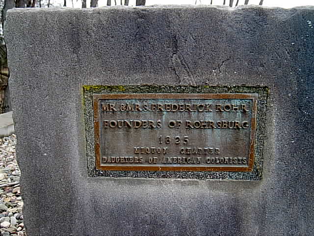
| Description | : | Next to the Christian Church in Rohrsburg, Greenwood Township, are the graves of Fredrick Rohr and his wife. According to the momument at the site dedicated to Mr and Mrs. Rohr by the Miquon Chapter of the Daughters of American Colonists, Frederick Rohr was the founder of Rohrsburg. There are just 2 headstones, with a small stone ( possibly a footstone) marked "F.R." The gravestones predate the church, which was established in 1871. the above information was obtained from the Cemeteries of Columbia County Volume 2 by the Columbia County Historical and Genealogical Society. Further information for these memorials obtained... Read More |
frequently asked questions (FAQ):
-
Where is Rohr Family Cemetery?
Rohr Family Cemetery is located at Rohrsburg, Columbia County ,Pennsylvania ,USA.
-
Rohr Family Cemetery cemetery's updated grave count on graveviews.com?
0 memorials
-
Where are the coordinates of the Rohr Family Cemetery?
Latitude: 41.1303000
Longitude: -76.4220000

Nearby Cemetories:
1. Rohrsburg Cemetery
Rohrsburg, Columbia County, USA
Coordinate: 41.1417007, -76.4207993
2. Lemon Cemetery
Greenwood, Columbia County, USA
Coordinate: 41.1410446, -76.4606400
3. Savage Hill Cemetery
Orangeville, Columbia County, USA
Coordinate: 41.1151000, -76.3785000
4. McHenry Cemetery
Orangeville, Columbia County, USA
Coordinate: 41.0931625, -76.4368210
5. Stillwater Cemetery
Stillwater, Columbia County, USA
Coordinate: 41.1444000, -76.3693000
6. Zion Cemetery
Stillwater, Columbia County, USA
Coordinate: 41.1253014, -76.3613968
7. Ikelers Cemetery
Greenwood, Columbia County, USA
Coordinate: 41.1135483, -76.4794083
8. Kitchens Cemetery
Columbia County, USA
Coordinate: 41.0978000, -76.4662000
9. Crouse Family Cemetery
Columbia County, USA
Coordinate: 41.0842970, -76.4408670
10. Laurel Hill Cemetery
Orangeville, Columbia County, USA
Coordinate: 41.0802994, -76.4203033
11. Greenwood Methodist Episcopal Church Cemetery
Millville, Columbia County, USA
Coordinate: 41.1319000, -76.4986000
12. Vallerchamp Cemetery
Columbia County, USA
Coordinate: 41.0735429, -76.4512078
13. New Ebenezer Cemetery
North Centre, Columbia County, USA
Coordinate: 41.0754000, -76.3705000
14. Benton Cemetery
Benton, Columbia County, USA
Coordinate: 41.1922188, -76.3824692
15. Ikelers Cemetery
Columbia County, USA
Coordinate: 41.0896034, -76.4962158
16. Jackson Township Cemetery
Derrs, Columbia County, USA
Coordinate: 41.1952000, -76.4551000
17. Saint James United Church of Christ Cemetery
Bendertown, Columbia County, USA
Coordinate: 41.1490000, -76.3296000
18. Old Ebenezer Cemetery
Orangeville, Columbia County, USA
Coordinate: 41.0739310, -76.3526130
19. Canby Cemetery
Millertown, Columbia County, USA
Coordinate: 41.0619000, -76.4692000
20. Millville Friends Cemetery
Millville, Columbia County, USA
Coordinate: 41.1229134, -76.5260849
21. Millville Cemetery
Millville, Columbia County, USA
Coordinate: 41.1230583, -76.5261459
22. Belles Cemetery
Columbia County, USA
Coordinate: 41.1741982, -76.3202972
23. Jonestown Cemetery
Jonestown, Columbia County, USA
Coordinate: 41.1299000, -76.3040000
24. Dodder Cemetery
Fishing Creek Township, Columbia County, USA
Coordinate: 41.1299640, -76.3038920