
| Memorials | : | 0 |
| Location | : | Belle Rose, Assumption Parish, USA |
| Coordinate | : | 30.0565000, -91.0515000 |
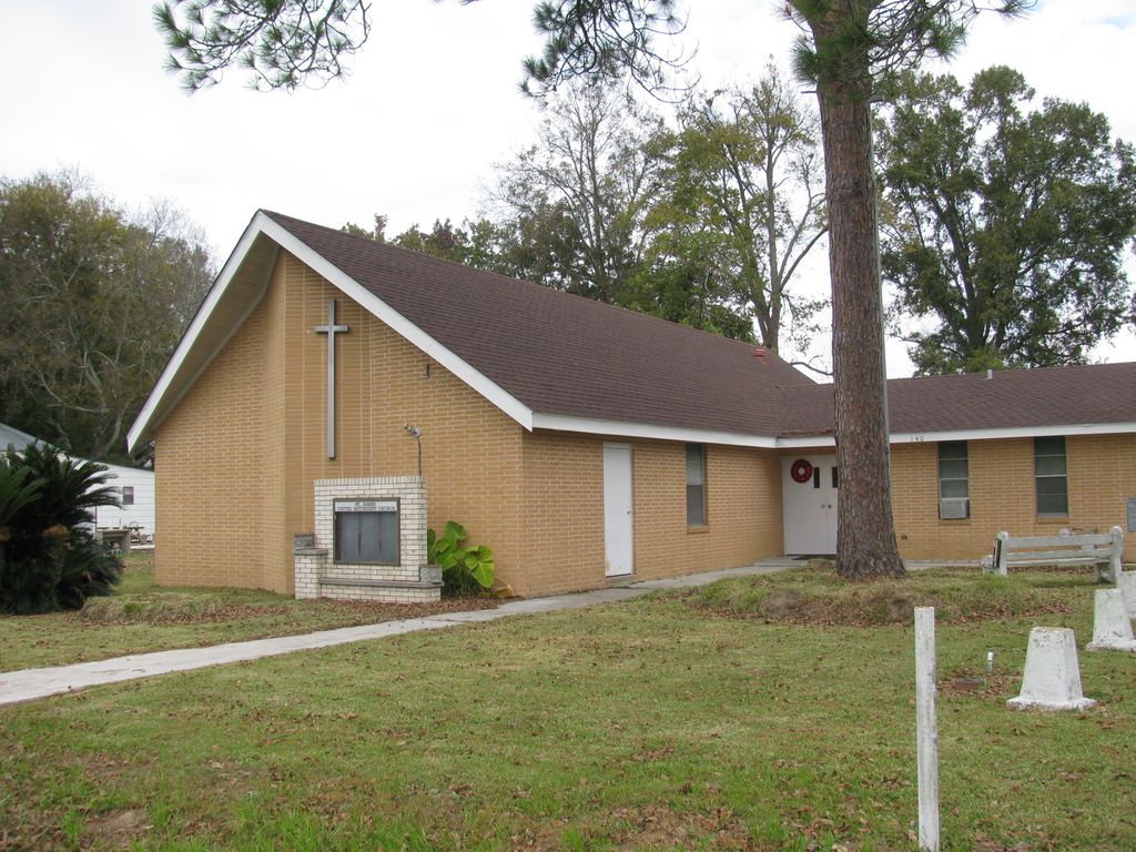
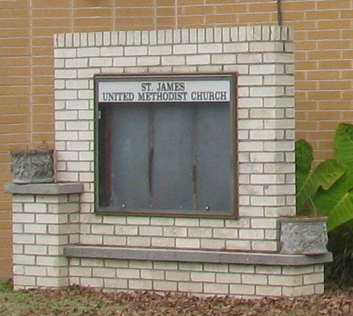
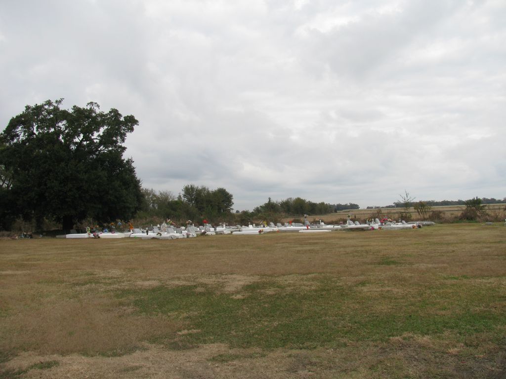
| Description | : | The simple cemetery is three quarters of mile west of highway LA-1, just before the railroad. It is 500 feet west of Rose Hill Baptist Church. St. James United Methodist Church, which sometimes is also associated with the cemetery, is on the same road but closer to LA-1. |
frequently asked questions (FAQ):
-
Where is Rose Hill Baptist Church Cemetery?
Rose Hill Baptist Church Cemetery is located at Highway LA-998 Belle Rose, Assumption Parish ,Louisiana ,USA.
-
Rose Hill Baptist Church Cemetery cemetery's updated grave count on graveviews.com?
0 memorials
-
Where are the coordinates of the Rose Hill Baptist Church Cemetery?
Latitude: 30.0565000
Longitude: -91.0515000
Nearby Cemetories:
1. Saint Jules Catholic Church Cemetery
Belle Rose, Assumption Parish, USA
Coordinate: 30.0541992, -91.0393982
2. Greater Israel Baptist Church Cemetery
Belle Alliance, Assumption Parish, USA
Coordinate: 30.0483110, -91.0402020
3. First Israel Baptist Church Cemetery
Belle Alliance, Assumption Parish, USA
Coordinate: 30.0493100, -91.0382400
4. Saint Jules Chapel Cemetery
Belle Rose, Assumption Parish, USA
Coordinate: 30.0507312, -91.0360697
5. Christ Cemetery
Assumption Parish, USA
Coordinate: 30.0307999, -91.0485992
6. Saint Augustine Cemetery
Klotzville, Assumption Parish, USA
Coordinate: 30.0186005, -91.0556030
7. Saint Martins Cemetery
Assumption Parish, USA
Coordinate: 30.0419006, -91.0988998
8. Emanuel Cemetery
Donaldsonville, Ascension Parish, USA
Coordinate: 30.0956001, -91.0261002
9. Virginia Baptist Church Cemetery
Paincourtville, Assumption Parish, USA
Coordinate: 30.0086002, -91.0522003
10. First Baptist Church Cemetery
Smoke Bend, Ascension Parish, USA
Coordinate: 30.1088800, -91.0216200
11. Second Mount Olive Baptist Church Cemetery
Smoke Bend, Ascension Parish, USA
Coordinate: 30.1073700, -91.0085800
12. Saint Francis of Assisi Catholic Church Cemetery
Smoke Bend, Ascension Parish, USA
Coordinate: 30.1065300, -91.0057400
13. Mount Triumph Baptist Church Cemetery
Donaldsonville, Ascension Parish, USA
Coordinate: 30.1022270, -90.9970490
14. Canaan Baptist Church Cemetery
Plattenville, Assumption Parish, USA
Coordinate: 29.9925000, -91.0340000
15. Saint Elizabeth Church Cemetery
Paincourtville, Assumption Parish, USA
Coordinate: 29.9900700, -91.0565000
16. Bikur Sholim Cemetery
Donaldsonville, Ascension Parish, USA
Coordinate: 30.0979750, -90.9890780
17. Mount Zion Baptist Church Cemetery
Donaldsonville, Ascension Parish, USA
Coordinate: 30.0981980, -90.9892470
18. Donaldsonville Protestant Cemetery
Donaldsonville, Ascension Parish, USA
Coordinate: 30.0985950, -90.9887190
19. Saint Charles Baptist Church Cemetery
Paincourtville, Assumption Parish, USA
Coordinate: 29.9868100, -91.0600900
20. Ascension of Our Lord Catholic Mausoleum
Donaldsonville, Ascension Parish, USA
Coordinate: 30.0986960, -90.9865160
21. Assumption of the Blessed Virgin Mary Cemetery
Plattenville, Assumption Parish, USA
Coordinate: 29.9900200, -91.0231800
22. Ascension of our Lord Catholic Church Cemetery
Donaldsonville, Ascension Parish, USA
Coordinate: 30.1002998, -90.9852982
23. Pilgrim Baptist Church Cemetery
Paincourtville, Assumption Parish, USA
Coordinate: 29.9850800, -91.0648900
24. Fort Butler Memorial
Donaldsonville, Ascension Parish, USA
Coordinate: 30.1078600, -90.9911600