
| Memorials | : | 0 |
| Location | : | Dronningmølle, Gribskov Kommune, Denmark |
| Phone | : | +4971 9177 |
| Website | : | www.rudolphtegner.dk/ |
| Coordinate | : | 56.0865480, 12.4007950 |
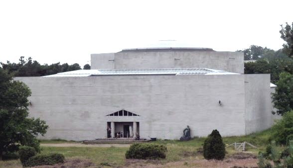
| Description | : | The Rudolph Tegner Museum began to take shape after sculptor Rudolph Tegner bought the land near Dronningmølle, north of Copenhagen, in 1916 and building the museum in 1938. The purpose of the museum was to have a place to exhibit his works. He and his wife are buried at the center of the museum. He is resting in a oak coffin under the floor in Great Middle Hall, and his wife's cremated ashes are in an urn placed at the base of the statue "Apollo." |
frequently asked questions (FAQ):
-
Where is Rudolph Tegner Museum and Statue Park?
Rudolph Tegner Museum and Statue Park is located at Museum Road 19 Dronningmølle, Gribskov Kommune ,Hovedstaden , 3120Denmark.
-
Rudolph Tegner Museum and Statue Park cemetery's updated grave count on graveviews.com?
0 memorials
-
Where are the coordinates of the Rudolph Tegner Museum and Statue Park?
Latitude: 56.0865480
Longitude: 12.4007950
Nearby Cemetories:
1. Gilleleje Churchyard
Gilleleje, Gribskov Kommune, Denmark
Coordinate: 56.1231700, 12.3103700
2. Hellebaek Cemetery
Hellebaek, Helsingør Kommune, Denmark
Coordinate: 56.0621750, 12.5557790
3. Mårum Kirke
Mårum, Gribskov Kommune, Denmark
Coordinate: 56.0251040, 12.2796150
4. Vikens Gamla Kyrkogård
Höganäs kommun, Sweden
Coordinate: 56.1436000, 12.5720000
5. Helsing
Helsingor, Helsingør Kommune, Denmark
Coordinate: 56.0372640, 12.6049230
6. Egebæksvang Kirkegård
Espergaerde, Helsingør Kommune, Denmark
Coordinate: 55.9949100, 12.5611900
7. Humlebaek Cemetery
Humlebaek, Fredensborg Kommune, Denmark
Coordinate: 55.9715314, 12.5414811
8. Skansekirkegården
Hillerød Kommune, Denmark
Coordinate: 55.9350453, 12.3351267
9. Nyhuse Kirkegård
Hillerød Kommune, Denmark
Coordinate: 55.9364317, 12.2891213
10. Hillerød Kirkegård
Hillerød Kommune, Denmark
Coordinate: 55.9295446, 12.3060183
11. Pålsjö Kyrkogård
Palsjo, Helsingborgs kommun, Sweden
Coordinate: 56.0739473, 12.6981281
12. Helsingborg Pålsjö Cemetery
Helsingborg, Helsingborgs kommun, Sweden
Coordinate: 56.0728600, 12.7000600
13. Nivå Kirkegård
Fredensborg Kommune, Denmark
Coordinate: 55.9242728, 12.4908606
14. Tibirke Churchyard
Tibirke, Gribskov Kommune, Denmark
Coordinate: 56.0416440, 12.1065550
15. Gamla kyrkogården
Helsingborg, Helsingborgs kommun, Sweden
Coordinate: 56.0425898, 12.7028561
16. Raa Kyrkogard
Helsingborg, Helsingborgs kommun, Sweden
Coordinate: 56.0066770, 12.7294818
17. Jonstorps Kyrkogård
Höganäs, Höganäs kommun, Sweden
Coordinate: 56.2280360, 12.6719080
18. Rungstedlund
Rungsted, Hørsholm Kommune, Denmark
Coordinate: 55.8833330, 12.5433330
19. Kropps kyrkogård
Kropp, Helsingborgs kommun, Sweden
Coordinate: 56.0859678, 12.7969199
20. Hørsholm Cemetery
Hørsholm, Hørsholm Kommune, Denmark
Coordinate: 55.8697500, 12.5066200
21. Vinderod Cemetery
Frederiksvaerk, Halsnæs Kommune, Denmark
Coordinate: 55.9850000, 12.0340000
22. Strovelstorp Kyrka Cemetery
Strovelstorp, Ängelholms kommun, Sweden
Coordinate: 56.1593328, 12.8378950
23. Melby Churchyard
Melby, Halsnæs Kommune, Denmark
Coordinate: 55.9958700, 11.9692130
24. Vedbæk Cemetery
Vedbaek, Rudersdal Kommune, Denmark
Coordinate: 55.8401970, 12.5647760