| Memorials | : | 0 |
| Location | : | Aurich, Landkreis Aurich, Germany |
| Coordinate | : | 53.5200437, 7.4741757 |
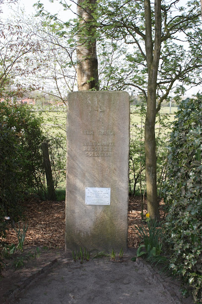
| Description | : | Tannesnhausen is a district of the county seat of Aurich. This is a World War II related cemetery outside the city limits. The community cemetery is located further south. Russian nationals, who either died in the Nazi's forced labor camps, or soldiers who died during combat in this area are buried in this small cemetery. Its graves are kept as a war memorial indefinitely. The ground is maintained by the city of Aurich. About 86 burials are documented, but according to witnesses at the time, the estimated number of buried persons is more likely around 200. |
frequently asked questions (FAQ):
-
Where is Russenfriedhof Tannenhausen?
Russenfriedhof Tannenhausen is located at Stürenburgweg Aurich, Landkreis Aurich ,Lower Saxony (Niedersachsen) , 26607Germany.
-
Russenfriedhof Tannenhausen cemetery's updated grave count on graveviews.com?
0 memorials
-
Where are the coordinates of the Russenfriedhof Tannenhausen?
Latitude: 53.5200437
Longitude: 7.4741757
Nearby Cemetories:
1. Friedhof Tannenhausen
Aurich, Landkreis Aurich, Germany
Coordinate: 53.5086280, 7.4732500
2. Friedhof Sandhorst
Aurich, Landkreis Aurich, Germany
Coordinate: 53.4904870, 7.4905570
3. Friedhof Plaggenburg
Aurich, Landkreis Aurich, Germany
Coordinate: 53.5114967, 7.5363287
4. Friedhof Walle
Walle, Landkreis Aurich, Germany
Coordinate: 53.4788190, 7.4419430
5. Friedhof Wallinghausen
Aurich, Landkreis Aurich, Germany
Coordinate: 53.4700470, 7.5176530
6. Friedhof Moorhusen
Landkreis Aurich, Germany
Coordinate: 53.5155040, 7.3691090
7. Friedhof Moordorf
Landkreis Aurich, Germany
Coordinate: 53.4774410, 7.3929650
8. Friedhof Blomberg Ostfriesland
Blomberg, Landkreis Wittmund, Germany
Coordinate: 53.5750020, 7.5458370
9. Friedhof Westerholt
Westerholt, Landkreis Wittmund, Germany
Coordinate: 53.5912025, 7.4584699
10. Friedhof Wiesens
Aurich, Landkreis Aurich, Germany
Coordinate: 53.4526150, 7.5556320
11. Friedhof Westerende
Westerende Kirchloog, Landkreis Aurich, Germany
Coordinate: 53.4428070, 7.4164820
12. Friedhof Berumerfehn
Grossheide, Landkreis Aurich, Germany
Coordinate: 53.5621750, 7.3461360
13. Friedhof Victorbur
Victorbur, Landkreis Aurich, Germany
Coordinate: 53.4858320, 7.3396980
14. Friedhof Rechtsupweg
Rechtsupweg, Landkreis Aurich, Germany
Coordinate: 53.5298350, 7.3275200
15. Friedhof Middels
Aurich, Landkreis Aurich, Germany
Coordinate: 53.5372000, 7.6217200
16. Neuer Friedhof Ochtersum
Westochtersum, Landkreis Wittmund, Germany
Coordinate: 53.6085986, 7.5028889
17. Alter Friedhof Ochtersum
Westochtersum, Landkreis Wittmund, Germany
Coordinate: 53.6090937, 7.5081946
18. Friedhof Grossheide
Grossheide, Landkreis Aurich, Germany
Coordinate: 53.5860270, 7.3576030
19. Friedhof Weene
Weene, Landkreis Aurich, Germany
Coordinate: 53.4271936, 7.5148798
20. Friedhof Weene
Weene, Landkreis Aurich, Germany
Coordinate: 53.4271600, 7.5148940
21. Friedhof Engerhafe
Engerhafe, Landkreis Aurich, Germany
Coordinate: 53.4878920, 7.3162940
22. Friedhof Brockzetel
Aurich, Landkreis Aurich, Germany
Coordinate: 53.4815100, 7.6312100
23. Alter Friedhof Arle
Arle, Landkreis Aurich, Germany
Coordinate: 53.6095000, 7.3911300
24. Arle Friedhof
Arle, Landkreis Aurich, Germany
Coordinate: 53.6084500, 7.3860700

