
| Memorials | : | 1 |
| Location | : | Woodleaf, Rowan County, USA |
| Coordinate | : | 35.7884712, -80.5620041 |
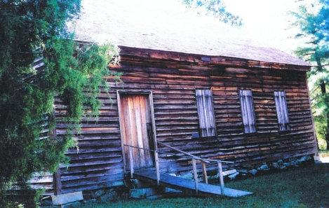
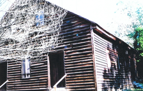
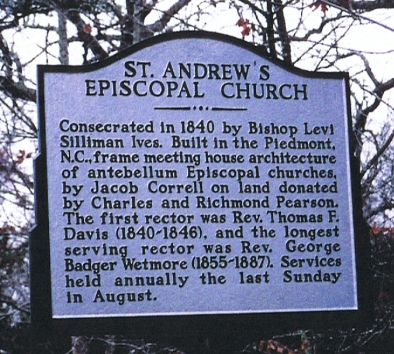
| Description | : | 0 ST. ANDREW'S CHURCH ROAD WOODLEAF, NC. 27054-9801 Directions: From NC HWY 801 in Woodleaf, NC. Turn on Wetmore Road (HWY 1949). Turn on Mattox Road/St. Andrew's Church Road (HWY 1950). St. Andrew's Episcopal Church was consecrated in 1840, built in the Piedmont NC frame meeting house type architecture of antebellum Episcopal churches. |
frequently asked questions (FAQ):
-
Where is Saint Andrews Episcopal Church Cemetery?
Saint Andrews Episcopal Church Cemetery is located at Woodleaf, Rowan County ,North Carolina ,USA.
-
Saint Andrews Episcopal Church Cemetery cemetery's updated grave count on graveviews.com?
1 memorials
-
Where are the coordinates of the Saint Andrews Episcopal Church Cemetery?
Latitude: 35.7884712
Longitude: -80.5620041
Nearby Cemetories:
1. Legion Memorial Park
Cooleemee, Davie County, USA
Coordinate: 35.8163890, -80.5494440
2. Pearson Family Cemetery
Davie County, USA
Coordinate: 35.8086100, -80.5326000
3. Emanuel Pentecostal Church
Woodleaf, Rowan County, USA
Coordinate: 35.7965180, -80.6037410
4. Unity Presbyterian Cemetery
Woodleaf, Rowan County, USA
Coordinate: 35.7613360, -80.6022520
5. Owens Cemetery
Franklin, Rowan County, USA
Coordinate: 35.7581730, -80.5205010
6. Second Creek AME Zion Cemetery
Franklin, Rowan County, USA
Coordinate: 35.7572189, -80.5209352
7. Jerusalem Baptist Church Cemetery
Mocksville, Davie County, USA
Coordinate: 35.8163250, -80.5165250
8. Boxwood Baptist Church Cemetery
Mocksville, Davie County, USA
Coordinate: 35.8000090, -80.5056810
9. Foard Family Cemetery
Davie County, USA
Coordinate: 35.8100400, -80.5054300
10. Cherry Hill Cemetery
Mocksville, Davie County, USA
Coordinate: 35.7992720, -80.5001500
11. Second Creek AME Zion - New Birth of Christ Church
Franklin Township, Rowan County, USA
Coordinate: 35.7461100, -80.5252800
12. Church of God of Prophecy Cemetery
Mocksville, Davie County, USA
Coordinate: 35.8387604, -80.5421524
13. The Arbor United Methodist Church Cemetery
Salisbury, Rowan County, USA
Coordinate: 35.7356700, -80.5509200
14. Liberty A.M.E. Zion Cemetery
Davie County, USA
Coordinate: 35.8416112, -80.5528552
15. Liberty United Methodist Church Cemetery
Mocksville, Davie County, USA
Coordinate: 35.8413930, -80.5495880
16. Mount Vernon Presbyterian Church
Cleveland, Rowan County, USA
Coordinate: 35.7653590, -80.6231360
17. Fairfield Baptist Church Cemetery
Mocksville, Davie County, USA
Coordinate: 35.8475640, -80.5460770
18. Corinth Church of Christ Cemetery
Rowan County, USA
Coordinate: 35.8101360, -80.6346300
19. New Bethel Baptist Church Cemetery
Mocksville, Davie County, USA
Coordinate: 35.8266190, -80.4948020
20. Daniel Family Cemetery
Davie County, USA
Coordinate: 35.8460830, -80.5173610
21. Cody Family Cemetery
Davie County, USA
Coordinate: 35.8400640, -80.5048510
22. Concord Methodist Church Cemetery
Cooleemee, Davie County, USA
Coordinate: 35.8394890, -80.5030136
23. Lebanon Lutheran Church Cemetery
Cleveland, Rowan County, USA
Coordinate: 35.7402300, -80.6266800
24. Calvary Baptist Church Cemetery
Mocksville, Davie County, USA
Coordinate: 35.8606070, -80.5480650