
| Memorials | : | 68 |
| Location | : | Ireland |
| Coordinate | : | 55.1500397, -7.1575928 |
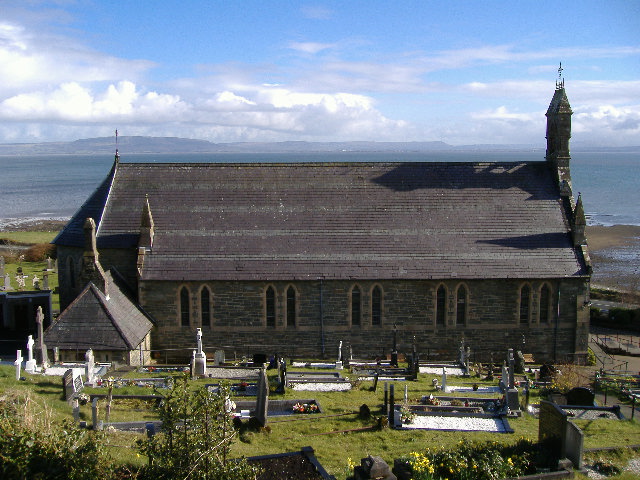
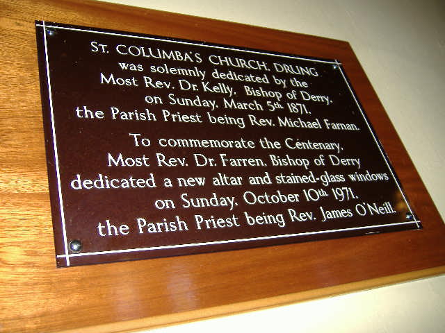
| Description | : | St. Columba's Roman Catholic Church and Churchyard is located in County Donegal, Ireland on the R238 road about 3 miles north of Quigley's Point. It is in a slightly elevated position and has commanding views over Lough Foyle towards Magilligan Strand in Northern Ireland. St. Columba's Church, Drung was build in 1871 close to the site of an earlier church and dedicated on Sunday October 5th 1871 by the Most Rev. Dr Kelly, Bishop of Derry. The Parish Priest was the Rev. Michael Farnan. The area of Drung was then part of the present parish of Lower Moville. The contractor's price... Read More |
frequently asked questions (FAQ):
-
Where is Saint Columba's Churchyard Drung?
Saint Columba's Churchyard Drung is located at County Donegal ,Ireland.
-
Saint Columba's Churchyard Drung cemetery's updated grave count on graveviews.com?
66 memorials
-
Where are the coordinates of the Saint Columba's Churchyard Drung?
Latitude: 55.1500397
Longitude: -7.1575928
Nearby Cemetories:
1. Greenbank Presbyterian, Quigleys Point
Ireland
Coordinate: 55.1215324, -7.2017102
2. Aghanloo Parish Church of Ireland Churchyard
Northern Ireland
Coordinate: 55.0902930, -6.9365470
3. Malinhead Lagg Cemetery
Ireland
Coordinate: 55.3219619, -7.3248322
4. Saint Aengus Roman Catholic Cemetery
Ireland
Coordinate: 55.0341400, -7.4496500
5. Our Lady of Lourdes Inch Island
Ireland
Coordinate: 55.0608711, -7.4913878
6. Dunnalong Church of Ireland Parish Churchyard
Northern Ireland
Coordinate: 54.9148100, -7.4201900
7. Our Lady & St. Patrick Church
Northern Ireland
Coordinate: 55.0662893, -6.5182577
8. Swatragh Granaghan Penal Chapel Cemetery
Northern Ireland
Coordinate: 54.8933050, -6.6672190
9. Mullagh Old Graveyard
Northern Ireland
Coordinate: 54.8343000, -6.6668200
10. St. Mary’s Roman Catholic Church Rasharkin
Northern Ireland
Coordinate: 54.9607480, -6.4821340
11. First Killymurris Presbyterian Church Cemetery
Northern Ireland
Coordinate: 54.9558230, -6.3584660
12. Baronscourt Parish Church
Northern Ireland
Coordinate: 54.6752210, -7.4584510
13. St Michaels RC Church Graveyard
Northern Ireland
Coordinate: 54.6901000, -6.7557300
14. Lissan Roman Catholic Church Cemetery
Northern Ireland
Coordinate: 54.6895690, -6.7555500
15. Templemoyle Old Graveyard
Northern Ireland
Coordinate: 54.8018790, -6.4167220
16. Grange of Ballyscullion Church Cemetery
Northern Ireland
Coordinate: 54.8015800, -6.4163200
17. Upper Langfield Church of Ireland
Northern Ireland
Coordinate: 54.6092758, -7.4551095
18. Church Of Ireland Lower Langfield
Northern Ireland
Coordinate: 54.6151042, -7.5065052
19. Discart Graveyard
Northern Ireland
Coordinate: 54.9859650, -6.1790210
20. An t-Sean Reilig Oileán Thoraigh
Ireland
Coordinate: 55.2646800, -8.2275090
21. St. Mary's Star of the Sea
Northern Ireland
Coordinate: 55.1688400, -6.0487100
22. Commonwealth War Graves Cemetery, Tory Island
Ireland
Coordinate: 55.2743700, -8.2489400
23. Tullanisken Holy Trinity Church of Ireland Church
Northern Ireland
Coordinate: 54.5509050, -6.7403120
24. St. Paul's Church of Ireland, Killeeshil Parish
Northern Ireland
Coordinate: 54.4877063, -6.9395925