
| Memorials | : | 4 |
| Location | : | Danbury, Fairfield County, USA |
| Coordinate | : | 41.3932750, -73.4528310 |
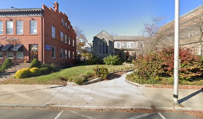
| Description | : | Placement of cremains located in church garden. |
frequently asked questions (FAQ):
-
Where is Saint James Episcopal Church Memorial Garden?
Saint James Episcopal Church Memorial Garden is located at 25 West Street Danbury, Fairfield County ,Connecticut , 06810USA.
-
Saint James Episcopal Church Memorial Garden cemetery's updated grave count on graveviews.com?
0 memorials
-
Where are the coordinates of the Saint James Episcopal Church Memorial Garden?
Latitude: 41.3932750
Longitude: -73.4528310
Nearby Cemetories:
1. Wooster Street Cemetery
Danbury, Fairfield County, USA
Coordinate: 41.3899540, -73.4495420
2. Saint James Church Cemetery
Danbury, Fairfield County, USA
Coordinate: 41.3863830, -73.4437250
3. Wooster Cemetery
Danbury, Fairfield County, USA
Coordinate: 41.4035988, -73.4503021
4. Old Saint Peters Cemetery
Danbury, Fairfield County, USA
Coordinate: 41.3909760, -73.4381104
5. Old North Main Street Cemetery
Danbury, Fairfield County, USA
Coordinate: 41.4044000, -73.4600000
6. Immanuel Lutheran Cemetery
Danbury, Fairfield County, USA
Coordinate: 41.4110489, -73.4499207
7. Saint Platons Russian Orthodox Cemetery
Danbury, Fairfield County, USA
Coordinate: 41.4129500, -73.4382900
8. Great Plain Cemetery
Danbury, Fairfield County, USA
Coordinate: 41.4174000, -73.4354000
9. Comes Cemetery
Danbury, Fairfield County, USA
Coordinate: 41.4068604, -73.4876099
10. United Jewish Cemetery
Danbury, Fairfield County, USA
Coordinate: 41.3694100, -73.4769000
11. Children of Israel Cemetery
Danbury, Fairfield County, USA
Coordinate: 41.3690681, -73.4772110
12. Miry Brook Cemetery
Danbury, Fairfield County, USA
Coordinate: 41.3686790, -73.4773636
13. New Saint Peter Cemetery
Danbury, Fairfield County, USA
Coordinate: 41.3859700, -73.4962280
14. Kenosia Cemetery
Danbury, Fairfield County, USA
Coordinate: 41.3857994, -73.4974136
15. Center Cemetery
Bethel, Fairfield County, USA
Coordinate: 41.3698692, -73.4129486
16. Westville Cemetery
Danbury, Fairfield County, USA
Coordinate: 41.4082910, -73.4996830
17. Congregational Church Cemetery
Bethel, Fairfield County, USA
Coordinate: 41.3729591, -73.4085693
18. 66 Nashville Road Cemetery
Bethel, Fairfield County, USA
Coordinate: 41.3653710, -73.4090270
19. Saint Marys Cemetery
Bethel, Fairfield County, USA
Coordinate: 41.3591995, -73.4167023
20. Pembroke Cemetery
Danbury, Fairfield County, USA
Coordinate: 41.4333000, -73.4772034
21. Stony Hill Cemetery
Bethel, Fairfield County, USA
Coordinate: 41.4055252, -73.3881607
22. Mill Plain Cemetery
Danbury, Fairfield County, USA
Coordinate: 41.3933600, -73.5197000
23. Upper Starrs Plain Cemetery
Danbury, Fairfield County, USA
Coordinate: 41.3392000, -73.4654000
24. Bethel Cemetery Elmwood Section
Bethel, Fairfield County, USA
Coordinate: 41.3769000, -73.3817000