
| Memorials | : | 2 |
| Location | : | Steele County, USA |
| Coordinate | : | 44.0264600, -93.0649700 |
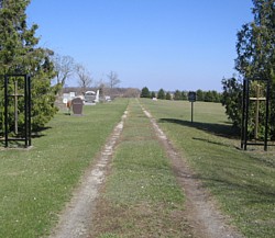
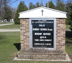
| Description | : | Cemetery is east of Owatonna, go on Hwy 14 about 5-8 miles, there will be a sign on the right that says St John Lutheran, turn right and go about 2 miles to the new church on the right and the cemetery on the left. |
frequently asked questions (FAQ):
-
Where is Saint Johns Evangelical Lutheran Cemetery?
Saint Johns Evangelical Lutheran Cemetery is located at Off of Hwy 84 Steele County ,Minnesota ,USA.
-
Saint Johns Evangelical Lutheran Cemetery cemetery's updated grave count on graveviews.com?
2 memorials
-
Where are the coordinates of the Saint Johns Evangelical Lutheran Cemetery?
Latitude: 44.0264600
Longitude: -93.0649700
Nearby Cemetories:
1. German Methodist Episcopal Cemetery
Steele County, USA
Coordinate: 44.0077782, -93.0658264
2. Thompson Cemetery
Havana, Steele County, USA
Coordinate: 44.0502815, -93.0958328
3. Aurora Lutheran Cemetery
Steele County, USA
Coordinate: 44.0366707, -93.1083298
4. Aurora Township Cemetery
Blooming Prairie, Steele County, USA
Coordinate: 44.0366707, -93.1083298
5. Saint Francis De Sales Catholic Cemetery
Claremont, Dodge County, USA
Coordinate: 44.0352783, -93.0049973
6. Hillside Cemetery
Claremont, Dodge County, USA
Coordinate: 44.0353012, -93.0049973
7. Amos Coggswell Cemetery (Defunct)
Steele County, USA
Coordinate: 43.9888890, -93.1200000
8. Havana Cemetery
Havana, Steele County, USA
Coordinate: 44.0732994, -93.1414032
9. Rice Lake Cemetery
Dodge County, USA
Coordinate: 44.0985985, -93.0374985
10. Claremont Street Cemetery
Claremont, Dodge County, USA
Coordinate: 44.0842018, -92.9816971
11. Dania Cemetery
Steele County, USA
Coordinate: 44.1027985, -93.1119003
12. Degner Cemetery
Steele County, USA
Coordinate: 44.0250015, -93.1853027
13. Ashland-Ripley Cemetery
Dodge Center, Dodge County, USA
Coordinate: 44.0222206, -92.9258270
14. Dane Cemetery
Owatonna, Steele County, USA
Coordinate: 44.0086000, -93.2100000
15. Bohemian National Cemetery
Owatonna, Steele County, USA
Coordinate: 44.0545000, -93.2086000
16. Union Cemetery
Steele County, USA
Coordinate: 43.9207993, -93.1138992
17. Westfield Lutheran Cemetery
Dodge County, USA
Coordinate: 43.9214400, -93.0047700
18. Holy Trinity Cemetery
Litomysl, Steele County, USA
Coordinate: 43.9516983, -93.1856003
19. Sacred Heart Cemetery
Owatonna, Steele County, USA
Coordinate: 44.0619011, -93.2264023
20. Steele Center Lutheran Cemetery
Steele County, USA
Coordinate: 43.9930992, -93.2367020
21. Danish Baptist Cemetery
Blooming Prairie, Steele County, USA
Coordinate: 43.9060734, -93.1260360
22. Forest Hill Cemetery
Owatonna, Steele County, USA
Coordinate: 44.0938988, -93.2185974
23. Saint John Lutheran Cemetery
Owatonna, Steele County, USA
Coordinate: 44.0956001, -93.2200012
24. Oak Mound Cemetery
Somerset Township, Steele County, USA
Coordinate: 43.9799995, -93.2463913