
| Memorials | : | 1 |
| Location | : | Paul Smiths, Franklin County, USA |
| Coordinate | : | 44.4405000, -74.2465500 |
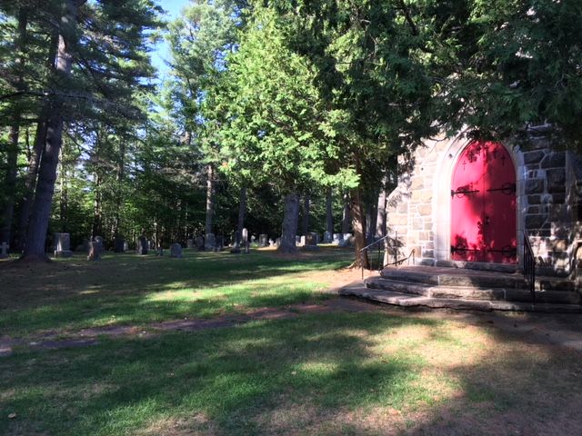
| Description | : | This church and its cemetery were founded in 1876 by Dr. Edward Livingston Trudeau with the help of Paul Smith and many of the wealthy camp owners around Spitfire, Upper Regis Lake and Lower Regis Lake. The original log building burned in 1928 and was replaced by the current church building in 1930. The cemetery surrounding the church is non-denominational. Church services are only held during the summer. The cemetery was transcribed on August 19, 2000 and the information checked against the records in the book "The Brighton Story" published in 1977. The transcribed list... Read More |
frequently asked questions (FAQ):
-
Where is Saint Johns In The Wilderness Episcopal Cemetery?
Saint Johns In The Wilderness Episcopal Cemetery is located at Paul Smiths, Franklin County ,New York ,USA.
-
Saint Johns In The Wilderness Episcopal Cemetery cemetery's updated grave count on graveviews.com?
1 memorials
-
Where are the coordinates of the Saint Johns In The Wilderness Episcopal Cemetery?
Latitude: 44.4405000
Longitude: -74.2465500
Nearby Cemetories:
1. Brighton Memorial Park
Gabriels, Franklin County, USA
Coordinate: 44.4331017, -74.1830978
2. Mountain View Cemetery
Gabriels, Franklin County, USA
Coordinate: 44.4211006, -74.1622009
3. Saint John in the Wilderness Cemetery
Lake Clear, Franklin County, USA
Coordinate: 44.3754400, -74.2293800
4. Eells- Lewis Cemetery
Lake Clear, Franklin County, USA
Coordinate: 44.3690670, -74.2263170
5. Harrietstown Cemetery
Lake Clear, Franklin County, USA
Coordinate: 44.3963600, -74.1584800
6. McColloms Cemetery
Franklin County, USA
Coordinate: 44.5122800, -74.3048000
7. LaBrake Family Cemetery
Harrietstown, Franklin County, USA
Coordinate: 44.3605170, -74.2082670
8. Kelley Cemetery
Harrietstown, Franklin County, USA
Coordinate: 44.3526500, -74.1323670
9. Union Cemetery
Vermontville, Franklin County, USA
Coordinate: 44.4411011, -74.0733032
10. Saint Pauls Cemetery
Franklin Falls, Franklin County, USA
Coordinate: 44.4152985, -74.0714035
11. Brookside Cemetery
Bloomingdale, Essex County, USA
Coordinate: 44.3926400, -74.0800800
12. Saint Bernards Cemetery
Saranac Lake, Franklin County, USA
Coordinate: 44.3306007, -74.1517029
13. Pine Ridge Cemetery
Saranac Lake, Essex County, USA
Coordinate: 44.3252983, -74.1232986
14. Hebrew Memorial Cemetery
Essex County, USA
Coordinate: 44.3233000, -74.1211500
15. Williams Grave
Franklin Falls, Franklin County, USA
Coordinate: 44.5371500, -74.0845667
16. Merrillsville Cemetery
Loon Lake, Franklin County, USA
Coordinate: 44.5278015, -74.0246964
17. Basin Cemetery
Franklin Falls, Franklin County, USA
Coordinate: 44.4387500, -73.9638667
18. Franklin Falls Cemetery
Franklin Falls, Franklin County, USA
Coordinate: 44.4267800, -73.9427600
19. Goodspeed Cemetery
Essex County, USA
Coordinate: 44.4213930, -73.9402580
20. Stickney Family Cemetery
Franklin Falls, Franklin County, USA
Coordinate: 44.4889833, -73.9444167
21. Ladd Cemetery
Franklin County, USA
Coordinate: 44.6610985, -74.2722015
22. Hoose Cemetery
Duane Center, Franklin County, USA
Coordinate: 44.6636009, -74.2256012
23. Saint Rose of Lima Roman Catholic Cemetery
Franklin County, USA
Coordinate: 44.5139383, -73.9443956
24. Saint Rose Cemetery
Franklin County, USA
Coordinate: 44.5141983, -73.9441986