
| Memorials | : | 0 |
| Location | : | Summit Hill, Carbon County, USA |
| Coordinate | : | 40.8248740, -75.8803900 |
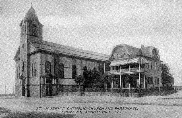
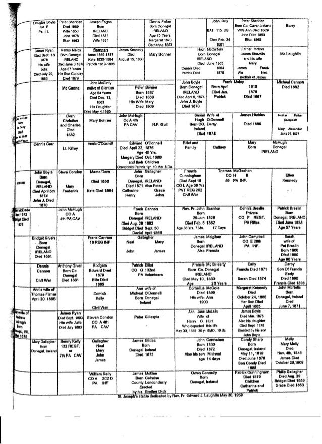
| Description | : | The cemetery has been cleared of all markers. A map and complete listing of burials is available at the church office. Other Civil War veterans possibly interred in this cemetery include Lt. Kilroy, Dennis Cannon, and Dominic Kelly. No other information is available about these men. 95% of the burials in this cemetery were before 1880. The last burial in the defunct St. Joseph's was about 1886. The cemetery was declared "abandoned" in 1959. The vast majority of the persons that were buried here were re-buried in Saint Joseph's Cemetery on White Street, Summit Hill. |
frequently asked questions (FAQ):
-
Where is Saint Joseph's Church Cemetery?
Saint Joseph's Church Cemetery is located at 462 West Ludlow Street Summit Hill, Carbon County ,Pennsylvania , 18250USA.
-
Saint Joseph's Church Cemetery cemetery's updated grave count on graveviews.com?
0 memorials
-
Where are the coordinates of the Saint Joseph's Church Cemetery?
Latitude: 40.8248740
Longitude: -75.8803900
Nearby Cemetories:
1. First Presbyterian Church Cemetery
Summit Hill, Carbon County, USA
Coordinate: 40.8269157, -75.8732758
2. Saint John the Baptist Byzantine Catholic Cemetery
Summit Hill, Carbon County, USA
Coordinate: 40.8270360, -75.8648980
3. Sacred Heart of Jesus Cemetery
Summit Hill, Carbon County, USA
Coordinate: 40.8266760, -75.8643830
4. Saint Joseph's Roman Catholic Cemetery
Summit Hill, Carbon County, USA
Coordinate: 40.8272000, -75.8642000
5. Saint Michael's Cemetery
Summit Hill, Carbon County, USA
Coordinate: 40.8270000, -75.8641000
6. Grand Army of the Republic Cemetery
Summit Hill, Carbon County, USA
Coordinate: 40.8276000, -75.8624000
7. Saint John's Slovak Lutheran Cemetery
Summit Hill, Carbon County, USA
Coordinate: 40.8276440, -75.8611840
8. Saint Mary's Russian Orthodox Cemetery
Summit Hill, Carbon County, USA
Coordinate: 40.8273970, -75.8600210
9. Saints Peter and Paul Catholic Cemetery
Summit Hill, Carbon County, USA
Coordinate: 40.8279000, -75.8589000
10. New Saint Joseph's Roman Catholic Cemetery
Bloomingdale, Carbon County, USA
Coordinate: 40.8313500, -75.8392900
11. Strauss Cemetery
Carbon County, USA
Coordinate: 40.7998804, -75.8411692
12. Saint Peter's Cemetery
Mantzville, Schuylkill County, USA
Coordinate: 40.7800860, -75.8665350
13. Christ Evangelical Free Church Cemetery
Lehighton, Carbon County, USA
Coordinate: 40.7870010, -75.8129920
14. Zimmerman Cemetery
Lehighton, Carbon County, USA
Coordinate: 40.8020000, -75.8010000
15. Zion Lutheran Cemetery
Tamaqua, Schuylkill County, USA
Coordinate: 40.8014920, -75.9610060
16. Saint John's Cemetery
Tamaqua, Schuylkill County, USA
Coordinate: 40.8005620, -75.9644670
17. Saints Peter and Paul RC Lithuanian Cemetery
Tamaqua, Schuylkill County, USA
Coordinate: 40.7880210, -75.9562470
18. Sky View Memorial Park
Hometown, Schuylkill County, USA
Coordinate: 40.8246340, -75.9707380
19. Protestant Cemetery
Nesquehoning, Carbon County, USA
Coordinate: 40.8649000, -75.8052000
20. Gates of Heaven Cemetery
Nesquehoning, Carbon County, USA
Coordinate: 40.8708000, -75.8099976
21. Sacred Heart Cemetery
Nesquehoning, Carbon County, USA
Coordinate: 40.8651190, -75.8040360
22. Saint John's Cemetery
Lehighton, Carbon County, USA
Coordinate: 40.8081000, -75.7885000
23. Normal Square Burial Ground
Lehighton, Carbon County, USA
Coordinate: 40.7863860, -75.8003000
24. Primitive Methodist Churchyard (Defunct)
Tamaqua, Schuylkill County, USA
Coordinate: 40.7956150, -75.9712710