| Memorials | : | 0 |
| Location | : | Gelting, Kreis Schleswig-Flensburg, Germany |
| Coordinate | : | 54.7492500, 9.8980700 |
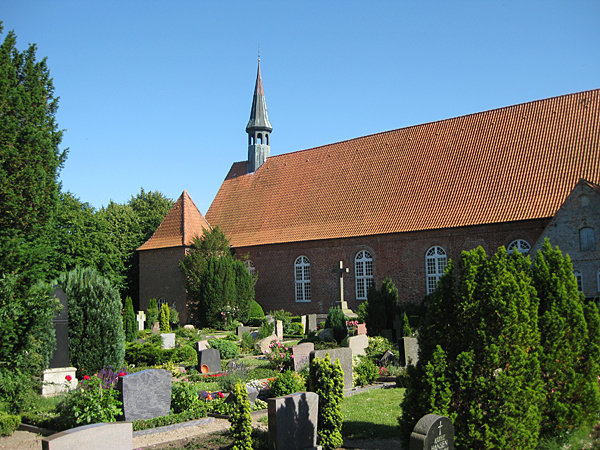
| Description | : | Saint Katherine's Lutheran Cemetery is located in the northern city of Gelting, Germany. The cemetery is composed of two sections; the older section adjacent to the church and a newer section located about 560ft (171m) to the west of the church. The newer section was established in 1839. In the older section of the cemetery near the west side of the church are several war memorials that list the names of local veterans. As is typical of the "recycling" habits of many cemeteries in Germany, the current graves are relatively young (20th century or newer). |
frequently asked questions (FAQ):
-
Where is Saint Katherine's Lutheran Cemetery?
Saint Katherine's Lutheran Cemetery is located at Gelting, Kreis Schleswig-Flensburg ,Schleswig-Holstein ,Germany.
-
Saint Katherine's Lutheran Cemetery cemetery's updated grave count on graveviews.com?
0 memorials
-
Where are the coordinates of the Saint Katherine's Lutheran Cemetery?
Latitude: 54.7492500
Longitude: 9.8980700
Nearby Cemetories:
1. Friedhof Esgrus
Esgrus, Kreis Schleswig-Flensburg, Germany
Coordinate: 54.7231804, 9.7807766
2. Friedhof Steinbergkirche
Steinbergkirche, Kreis Schleswig-Flensburg, Germany
Coordinate: 54.7548598, 9.7595285
3. Friedhof Kappeln
Kappeln, Kreis Schleswig-Flensburg, Germany
Coordinate: 54.6631820, 9.9279050
4. St. Laurentius Church Cemetery
Schleswig, Kreis Schleswig-Flensburg, Germany
Coordinate: 54.7287840, 9.7385640
5. Friedhof Groß-Quern
Grossquern, Kreis Schleswig-Flensburg, Germany
Coordinate: 54.7538557, 9.7214119
6. Neukirchen
Neukirchen, Kreis Schleswig-Flensburg, Germany
Coordinate: 54.8028983, 9.7452064
7. Friedhof Arnis
Arnis, Kreis Schleswig-Flensburg, Germany
Coordinate: 54.6281309, 9.9291287
8. Friedhof Süderbrarup
Suderbrarup, Kreis Schleswig-Flensburg, Germany
Coordinate: 54.6355244, 9.7812667
9. Ehrenfriedhof Sorup
Sorup, Kreis Schleswig-Flensburg, Germany
Coordinate: 54.7148025, 9.6686758
10. Friedhof Grundhof
Grundhof, Kreis Schleswig-Flensburg, Germany
Coordinate: 54.7736834, 9.6538035
11. Friedhof Boren
Boren, Kreis Schleswig-Flensburg, Germany
Coordinate: 54.6130694, 9.8193239
12. Friedhof Sieseby
Sieseby, Kreis Rendsburg-Eckernförde, Germany
Coordinate: 54.5945163, 9.8606256
13. Neuer Friedhof
Sonderborg, Sønderborg Kommune, Denmark
Coordinate: 54.9092820, 9.8073570
14. Sønderborg Castle
Sonderborg, Sønderborg Kommune, Denmark
Coordinate: 54.9069210, 9.7843830
15. Sankt Marie Kirkegard
Sonderborg, Sønderborg Kommune, Denmark
Coordinate: 54.9127780, 9.7882120
16. St. Johannis Ev-Lutheran
Schnarup-Thumby, Kreis Schleswig-Flensburg, Germany
Coordinate: 54.6479554, 9.6449465
17. St. Laurentius-Kirche zu Satrup
Satrup, Kreis Schleswig-Flensburg, Germany
Coordinate: 54.6920325, 9.6030886
18. Friedhof Satrup
Satrup, Kreis Schleswig-Flensburg, Germany
Coordinate: 54.6902714, 9.6032723
19. Husby Church Cemetery
Husby, Kreis Schleswig-Flensburg, Germany
Coordinate: 54.7623730, 9.5770740
20. Friedhof Ulsnis
Ulsnis, Kreis Schleswig-Flensburg, Germany
Coordinate: 54.5737968, 9.7475981
21. Augustenburg Friedhof
Sonderborg, Sønderborg Kommune, Denmark
Coordinate: 54.9479900, 9.8809100
22. Friedhof Munkbrarup
Munkbrarup, Kreis Schleswig-Flensburg, Germany
Coordinate: 54.8024365, 9.5622506
23. Friedhof Uelsby
Uelsbyholz, Kreis Schleswig-Flensburg, Germany
Coordinate: 54.6333178, 9.5961280
24. Friedhof St.-Annen-Kirche zu Taarstedt
Taarstedt, Kreis Schleswig-Flensburg, Germany
Coordinate: 54.5752807, 9.6913125

