
| Memorials | : | 1 |
| Location | : | Norwich, City of Norwich, England |
| Coordinate | : | 52.6307240, 1.3025470 |
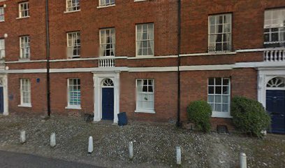
| Description | : | St Mary in the Marsh was the parish church of the cathedral precinct in Norwich. The parish was founded before the Norman conquest, and the church was in active use through the 16th century. In 1560 the church was closed and the parish began to use St Luke’s Chapel in the cathedral for worship. The church was pulled down in 1564, and some remains of the church building were incorporated into a row of houses in Lower Close; there is a blue plaque marking the location on number 12. |
frequently asked questions (FAQ):
-
Where is Saint Mary In The Marsh Churchyard?
Saint Mary In The Marsh Churchyard is located at Norwich, City of Norwich ,Norfolk ,England.
-
Saint Mary In The Marsh Churchyard cemetery's updated grave count on graveviews.com?
1 memorials
-
Where are the coordinates of the Saint Mary In The Marsh Churchyard?
Latitude: 52.6307240
Longitude: 1.3025470
Nearby Cemetories:
1. Norwich Cathedral
Norwich, City of Norwich, England
Coordinate: 52.6319420, 1.3016020
2. St. Helen's Churchyard
Norwich, City of Norwich, England
Coordinate: 52.6328420, 1.3044730
3. Saint George-Tombland Parish Church
Norwich, City of Norwich, England
Coordinate: 52.6312220, 1.2985100
4. St. Mary The Less Church
Norwich, City of Norwich, England
Coordinate: 52.6305650, 1.2982900
5. St. Martin at Palace Church
Norwich, City of Norwich, England
Coordinate: 52.6335450, 1.3017730
6. St. Julian Churchyard
Norwich, City of Norwich, England
Coordinate: 52.6336490, 1.3010100
7. St. Michael at Plea Cemetery
Norwich, City of Norwich, England
Coordinate: 52.6305230, 1.2972160
8. St Simon & St Jude Church Cemetery
Norwich, City of Norwich, England
Coordinate: 52.6320630, 1.2976390
9. St. Peter's Hungate Churchyard
Norwich, City of Norwich, England
Coordinate: 52.6311100, 1.2970000
10. Princes Street Chapel
Norwich, City of Norwich, England
Coordinate: 52.6309470, 1.2969650
11. Black Friars
Norwich, City of Norwich, England
Coordinate: 52.6311800, 1.2959050
12. St. Edmund's Churchyard
Norwich, City of Norwich, England
Coordinate: 52.6342780, 1.2989640
13. Norwich Castle
Norwich, City of Norwich, England
Coordinate: 52.6286810, 1.2963990
14. Austin Friars Church Cemetery
Norwich, City of Norwich, England
Coordinate: 52.6283330, 1.2966670
15. St. Andrew's Churchyard
Norwich, City of Norwich, England
Coordinate: 52.6304640, 1.2953880
16. St. Clement the Martyr Churchyard
Norwich, City of Norwich, England
Coordinate: 52.6332670, 1.2966570
17. Whitefriars
Norwich, City of Norwich, England
Coordinate: 52.6351750, 1.3006400
18. Old Meeting House
Norwich, City of Norwich, England
Coordinate: 52.6338830, 1.2956790
19. St James with Pockthorpe Churchyard
Norwich, City of Norwich, England
Coordinate: 52.6359070, 1.3001060
20. St. Saviour Churchyard
Norwich, City of Norwich, England
Coordinate: 52.6351710, 1.2968890
21. St George Colegate Church
Norwich, City of Norwich, England
Coordinate: 52.6332060, 1.2940200
22. St. John Maddermarket Church
Norwich, City of Norwich, England
Coordinate: 52.6300230, 1.2927980
23. Saint John Timberhill Churchyard
Norwich, City of Norwich, England
Coordinate: 52.6261280, 1.2961320
24. St. Peter's Churchyard Southgate
Norwich, City of Norwich, England
Coordinate: 52.6246548, 1.3016819