
| Memorials | : | 0 |
| Location | : | Coffee County, USA |
| Coordinate | : | 31.3432500, -85.8921700 |
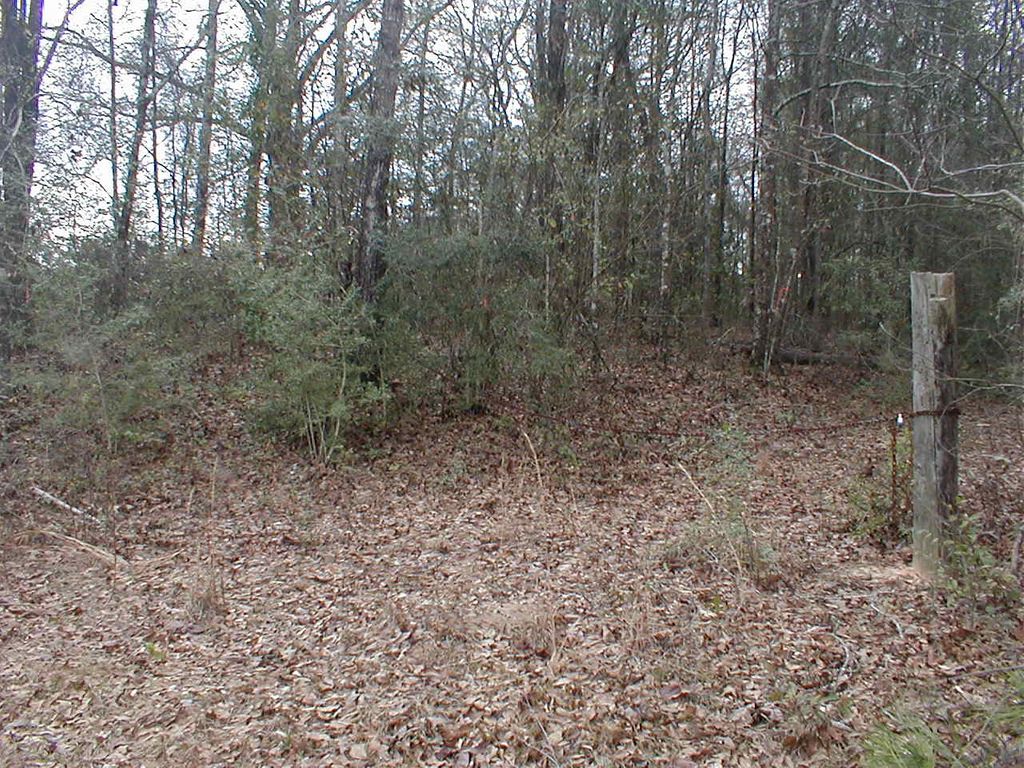
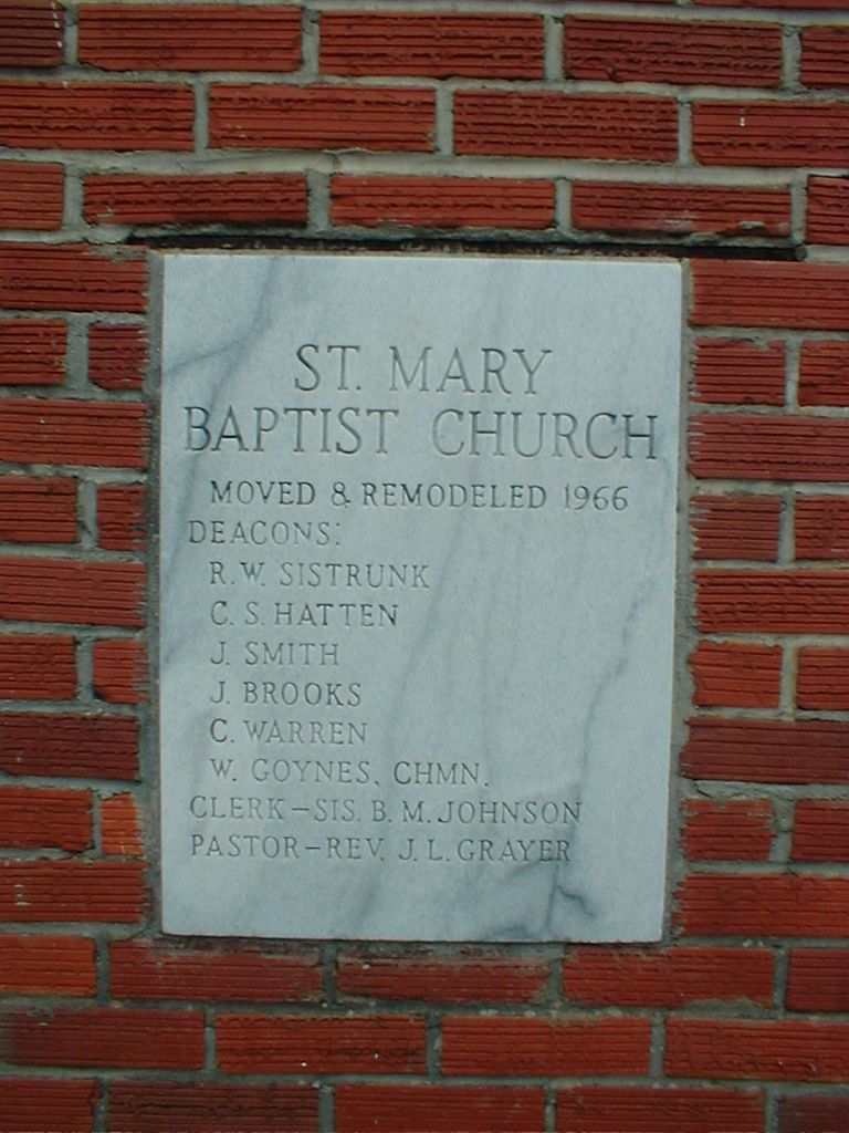
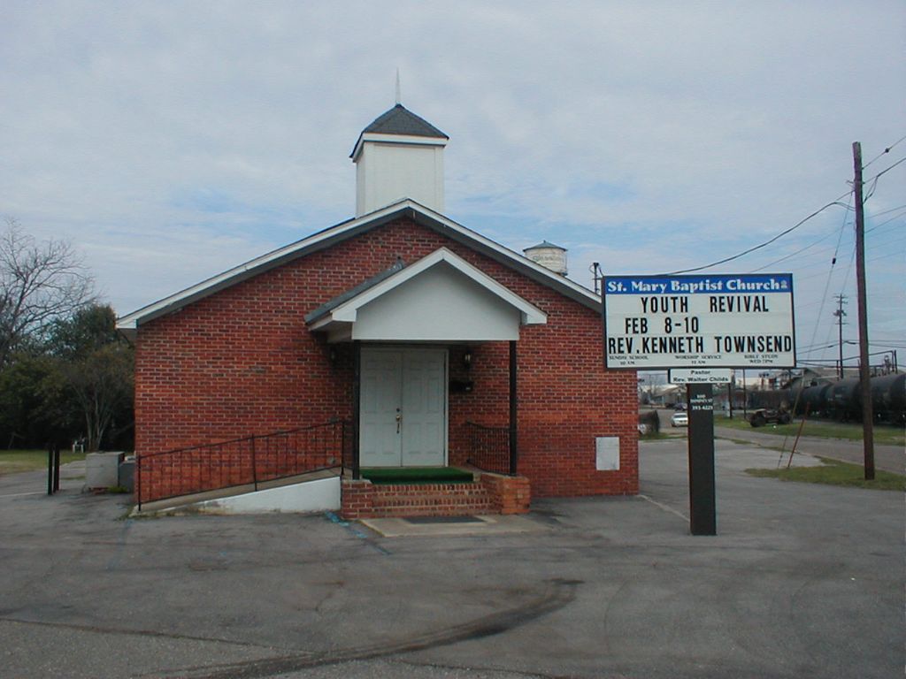
| Description | : | This is an abandoned black cemetery located about a mile west of Hwy 184 and about a half mile north of the circle in Enterprise Alabama. Saint Mary Missionary Baptist Church is located at 100 Dominey Street, Enterprise, AL. The church was moved form where the cemetery is located to it's present location in 1966, remodeled and the outside changed from lumber painted white to brick. The land where the church and cemetery were located belongs to the Moates family. GPS readings: Latitude 31.34325 degrees north, Longitude 85.89217 degrees west, County road 520, Enterprise Coffee County Alabama. 2.5 miles> county road... Read More |
frequently asked questions (FAQ):
-
Where is Saint Mary Missionary Baptist Church Cemetery?
Saint Mary Missionary Baptist Church Cemetery is located at Coffee County ,Alabama ,USA.
-
Saint Mary Missionary Baptist Church Cemetery cemetery's updated grave count on graveviews.com?
0 memorials
-
Where are the coordinates of the Saint Mary Missionary Baptist Church Cemetery?
Latitude: 31.3432500
Longitude: -85.8921700

Nearby Cemetories:
1. Calvary Baptist Church Cemetery
Enterprise, Coffee County, USA
Coordinate: 31.3717003, -85.8850021
2. Saint Beulah Baptist Church Cemetery
Enterprise, Coffee County, USA
Coordinate: 31.3154580, -85.8639370
3. Enterprise City Cemetery
Enterprise, Coffee County, USA
Coordinate: 31.3194008, -85.8574982
4. Bethany Baptist Church Cemetery
New Brockton, Coffee County, USA
Coordinate: 31.3408451, -85.9428940
5. Salem Cemetery
Coffee County, USA
Coordinate: 31.3677998, -85.8388977
6. New Brockton City Cemetery
New Brockton, Coffee County, USA
Coordinate: 31.3866997, -85.9269028
7. Johns Chapel AME Church Cemetery
Enterprise, Coffee County, USA
Coordinate: 31.3022003, -85.8535004
8. Salem Baptist Church Cemetery
Coffee County, USA
Coordinate: 31.3688010, -85.8378360
9. Pleasant Ridge United Methodist Church Cemetery
Coffee County, USA
Coordinate: 31.3013992, -85.9325027
10. Morning Star Cemetery
Enterprise, Coffee County, USA
Coordinate: 31.2931004, -85.9313965
11. Richburg Cemetery
Coffee County, USA
Coordinate: 31.3866005, -85.9505997
12. Meadowlawn Cemetery
Enterprise, Coffee County, USA
Coordinate: 31.2757816, -85.8794098
13. Precious Memory Cemetery
Enterprise, Coffee County, USA
Coordinate: 31.3110700, -85.8152300
14. Old Wellborn Cemetery
New Brockton, Coffee County, USA
Coordinate: 31.3446450, -85.9798710
15. Pleasant Grove Cemetery
Enterprise, Coffee County, USA
Coordinate: 31.3096008, -85.8115997
16. Wooten Chapel Church Cemetery
Coffee County, USA
Coordinate: 31.3535710, -85.9815290
17. Wesley Chapel Cemetery
Coffee County, USA
Coordinate: 31.4102993, -85.8463974
18. Kelley Family Cemetery
New Brockton, Coffee County, USA
Coordinate: 31.3712860, -85.9774480
19. Alberson Family Cemetery
Coffee County, USA
Coordinate: 31.3328400, -85.7992500
20. New Home Cemetery
Coffee County, USA
Coordinate: 31.2735996, -85.9396973
21. Mount Zion Cemetery
Coffee County, USA
Coordinate: 31.3227997, -85.8005981
22. Mount Pleasant Primitive Baptist Cemetery
New Brockton, Coffee County, USA
Coordinate: 31.4242001, -85.8921967
23. Keyton Cemetery
Coffee County, USA
Coordinate: 31.2831001, -85.8285980
24. Hardshell Cemetery
New Brockton, Coffee County, USA
Coordinate: 31.4249510, -85.8920700