
| Memorials | : | 2 |
| Location | : | Madisonville, Hamilton County, USA |
| Phone | : | (513) 271-0920 |
| Coordinate | : | 39.1571000, -84.3848800 |
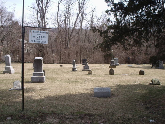
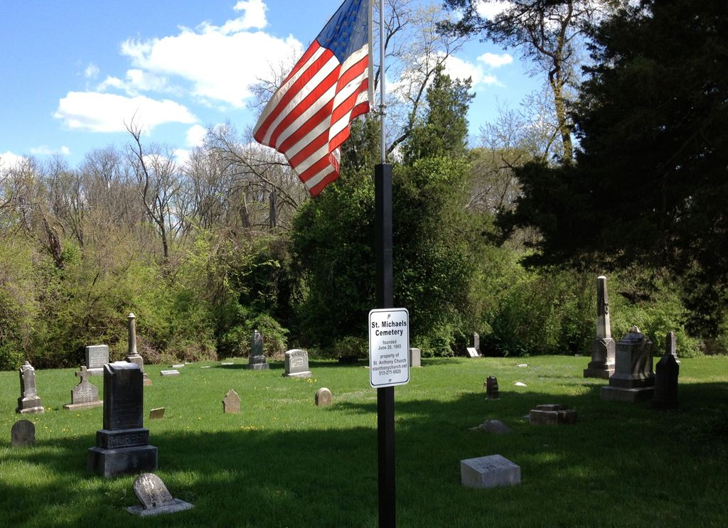
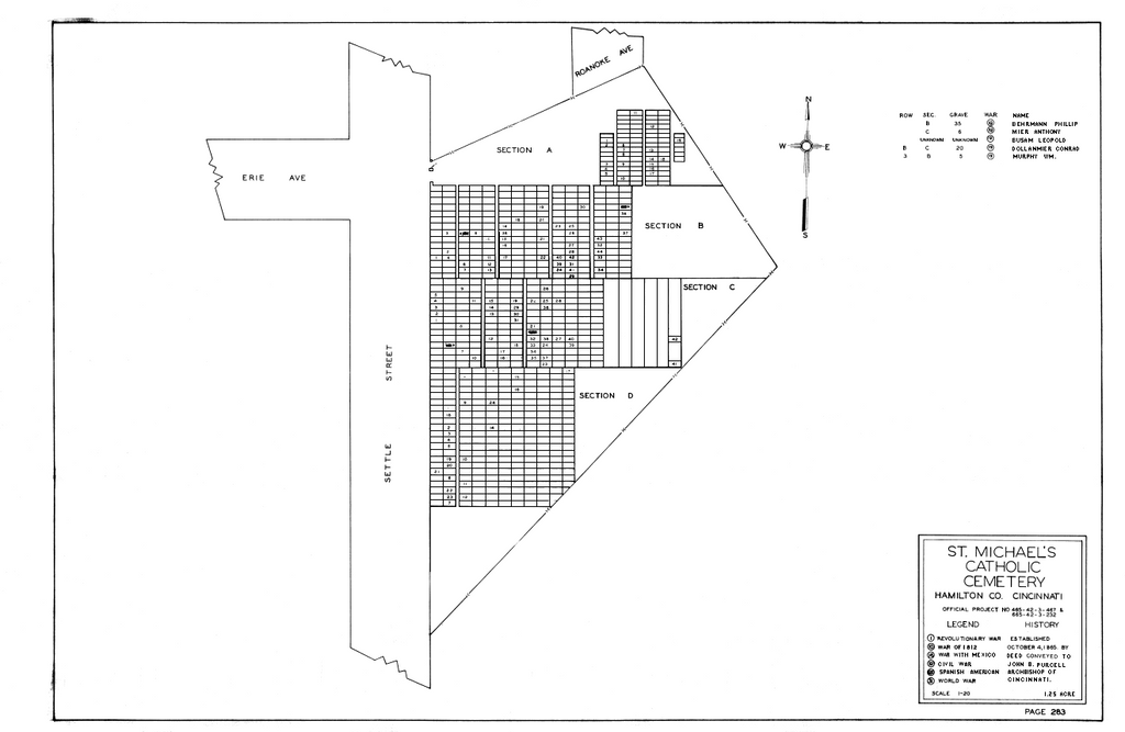
| Description | : | Saint Michael's Catholic Cemetery is located on Settle Street (off of Erie Avenue) in Madisonville and sits on the site of the original Saint Michael's Catholic Church, established in October of 1859. Among the interments are members of Saint Anthony's Catholic Church which replaced Saint Michael's in September of 1874. The cemetery is now affiliated with: St. Anthony Church 6104 Desmond Street Madisonville, Ohio 45227 (513) 271-0290 The cemetery is located in Columbia Township, Hamilton County, Ohio, and is # 4601 (Saint Michaels Catholic Cemetery / Saint Michaels Cemetery / Madisonville Cemetery) in “Ohio Cemeteries 1803-2003”, compiled by the Ohio Genealogical Society. The cemetery is registered with... Read More |
frequently asked questions (FAQ):
-
Where is Saint Michaels Catholic Cemetery?
Saint Michaels Catholic Cemetery is located at 725 Settle Road Madisonville, Hamilton County ,Ohio , 45227USA.
-
Saint Michaels Catholic Cemetery cemetery's updated grave count on graveviews.com?
2 memorials
-
Where are the coordinates of the Saint Michaels Catholic Cemetery?
Latitude: 39.1571000
Longitude: -84.3848800
Nearby Cemetories:
1. Laurel IOOF Cemetery
Madisonville, Hamilton County, USA
Coordinate: 39.1542015, -84.3917007
2. Ferris Family Cemetery
Mariemont, Hamilton County, USA
Coordinate: 39.1458549, -84.3789291
3. Duck Creek Baptist Church Cemetery
Madisonville, Hamilton County, USA
Coordinate: 39.1652718, -84.4079132
4. John Jones Family Cemetery
Madeira, Hamilton County, USA
Coordinate: 39.1788292, -84.3798523
5. United American Cemetery
Madisonville, Hamilton County, USA
Coordinate: 39.1660995, -84.4139023
6. John Mann Farm Cemetery (Defunct)
Madeira, Hamilton County, USA
Coordinate: 39.1803170, -84.3643420
7. Armstrong Chapel Cemetery
Indian Hill, Hamilton County, USA
Coordinate: 39.1601600, -84.3472200
8. Knox Presbyterian Church Columbarium
Hyde Park, Hamilton County, USA
Coordinate: 39.1846081, -84.3569411
9. Martin Cemetery #1
Newtown, Hamilton County, USA
Coordinate: 39.1259280, -84.3621190
10. Indian Hill Episcopal Presbyterian Churchyard
Cincinnati, Hamilton County, USA
Coordinate: 39.1748880, -84.3441490
11. Flag Spring Cemetery
Newtown, Hamilton County, USA
Coordinate: 39.1272011, -84.3555984
12. Hetzler Family Cemetery
Madeira, Hamilton County, USA
Coordinate: 39.1914024, -84.3625946
13. All Saints Episcopal Church Memorial Garden
Pleasant Ridge, Hamilton County, USA
Coordinate: 39.1856910, -84.4241000
14. Joseph of Arimethea Columbarium
Cincinnati, Hamilton County, USA
Coordinate: 39.1389470, -84.4336500
15. Hyde Park Community UMC Columbarium
Hyde Park, Hamilton County, USA
Coordinate: 39.1363820, -84.4326970
16. Pleasant Ridge Presbyterian Cemetery
Pleasant Ridge, Hamilton County, USA
Coordinate: 39.1794014, -84.4332962
17. Knox Presbyterian Church
Cincinnati, Hamilton County, USA
Coordinate: 39.1378980, -84.4415180
18. Martin Family Cemetery
Newtown, Hamilton County, USA
Coordinate: 39.1400060, -84.3226040
19. Marriott Cemetery (Defunct)
Ancor, Hamilton County, USA
Coordinate: 39.1442610, -84.3187690
20. Fulton Cemetery
Hyde Park, Hamilton County, USA
Coordinate: 39.1406364, -84.4506302
21. Sycamore Township Memorial Cemetery
Kenwood, Hamilton County, USA
Coordinate: 39.2118700, -84.3794500
22. Old Indian Hill Baptist Churchyard
Indian Hill, Hamilton County, USA
Coordinate: 39.1628685, -84.3127518
23. Columbia Baptist Church Cemetery
Cincinnati, Hamilton County, USA
Coordinate: 39.1063995, -84.4282990
24. Fulton-Presbyterian Cemetery
Fulton, Hamilton County, USA
Coordinate: 39.1074982, -84.4332962