
| Memorials | : | 3 |
| Location | : | Beaver Dam, Dodge County, USA |
| Coordinate | : | 43.4422100, -88.8598300 |
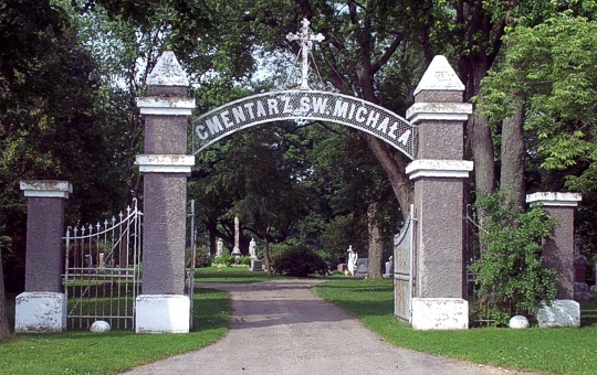
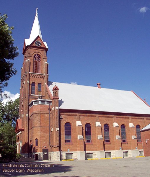
| Description | : | Located on the south side of Road G. The Parish of St. Michael in Beaver Dam "In Beaver Dam, or Bobrowy Gród in Polish, a town in Dodge County opposite a lake in which beavers at one time built their homes, on the height of a gentle hill among the trees, there rises a small church, and next to it there is a school, and on the other side a modest rectory which is hardly visible between the trees. It is the property of the the parish of St. Michael, which was organized in 1875. Some of the Poles live in the... Read More |
frequently asked questions (FAQ):
-
Where is Saint Michaels Catholic Cemetery?
Saint Michaels Catholic Cemetery is located at Road G Beaver Dam, Dodge County ,Wisconsin ,USA.
-
Saint Michaels Catholic Cemetery cemetery's updated grave count on graveviews.com?
3 memorials
-
Where are the coordinates of the Saint Michaels Catholic Cemetery?
Latitude: 43.4422100
Longitude: -88.8598300
Nearby Cemetories:
1. First Evangelical Lutheran Church Cemetery
Beaver Dam, Dodge County, USA
Coordinate: 43.4436000, -88.8595500
2. Saint Marys Cemetery
Beaver Dam, Dodge County, USA
Coordinate: 43.4436000, -88.8587200
3. Old Saint Michaels Cemetery
Beaver Dam, Dodge County, USA
Coordinate: 43.4438870, -88.8579740
4. Saint Peters Cemetery
Beaver Dam, Dodge County, USA
Coordinate: 43.4399986, -88.8435974
5. Saint Patricks Cemetery
Beaver Dam, Dodge County, USA
Coordinate: 43.4392014, -88.8424988
6. Calamus Cemetery
South Beaver Dam, Dodge County, USA
Coordinate: 43.4373093, -88.8920135
7. Saint Marks Episcopal Church Columbarium
Beaver Dam, Dodge County, USA
Coordinate: 43.4535620, -88.8248650
8. Beaver Dam City Cemetery
Beaver Dam, Dodge County, USA
Coordinate: 43.4658200, -88.8287200
9. Leipsig Cemetery
Beaver Dam, Dodge County, USA
Coordinate: 43.4063800, -88.8734400
10. Oakwood Cemetery
Beaver Dam, Dodge County, USA
Coordinate: 43.4571991, -88.8127975
11. English Prairie Cemetery
South Beaver Dam, Dodge County, USA
Coordinate: 43.4953499, -88.9002075
12. Clason Prairie Cemetery
Beaver Dam, Dodge County, USA
Coordinate: 43.4136000, -88.7809400
13. Salem Cemetery
Calamus, Dodge County, USA
Coordinate: 43.3963800, -88.9331600
14. Hyland Prairie Cemetery
Oak Grove, Dodge County, USA
Coordinate: 43.4444400, -88.7506600
15. Bethany Cemetery
Calamus, Dodge County, USA
Coordinate: 43.4152985, -88.9653015
16. Annunciation Cemetery
Fox Lake, Dodge County, USA
Coordinate: 43.5311012, -88.8660965
17. Wanderers Rest Cemetery
Lost Lake, Dodge County, USA
Coordinate: 43.4500237, -88.9901352
18. Oak Grove Cemetery
Oak Grove, Dodge County, USA
Coordinate: 43.3863983, -88.7510986
19. Annunciation Cemetery
Lost Lake, Dodge County, USA
Coordinate: 43.4583200, -88.9920500
20. Burnett Corners Cemetery
Burnett, Dodge County, USA
Coordinate: 43.4948997, -88.7430954
21. Grove Prairie Cemetery
Reeseville, Dodge County, USA
Coordinate: 43.3361015, -88.8775024
22. Lowell Cemetery
Lowell, Dodge County, USA
Coordinate: 43.3375390, -88.8146670
23. Saint Johns Catholic Cemetery
Lowell, Dodge County, USA
Coordinate: 43.3353000, -88.8237000
24. Stone Cemetery
Rolling Prairie, Dodge County, USA
Coordinate: 43.4738998, -88.7089005