
| Memorials | : | 59 |
| Location | : | Eastville, East Lindsey District, England |
| Coordinate | : | 53.1134100, 0.1012600 |
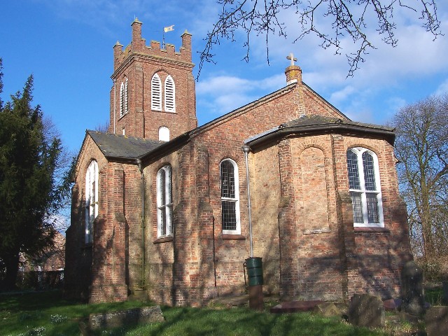
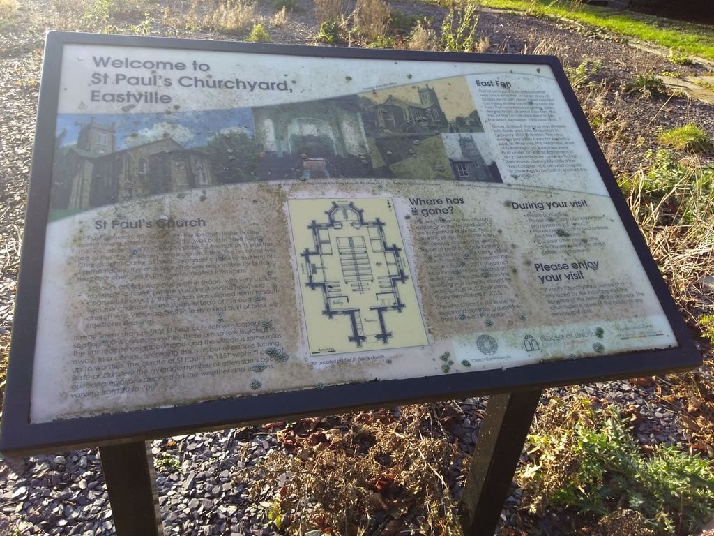
| Description | : | Saint Paul's church was built in 1840 and ceased worship in 2007 due to major structural damage and the risk of collapse. The church was eventually demolished in 2015, though the churchyard remains intact. |
frequently asked questions (FAQ):
-
Where is Saint Paul's Churchyard?
Saint Paul's Churchyard is located at Spilsby Road Eastville, East Lindsey District ,Lincolnshire ,England.
-
Saint Paul's Churchyard cemetery's updated grave count on graveviews.com?
59 memorials
-
Where are the coordinates of the Saint Paul's Churchyard?
Latitude: 53.1134100
Longitude: 0.1012600
Nearby Cemetories:
1. St. Andrew's Churchyard
Little Steeping, East Lindsey District, England
Coordinate: 53.1498640, 0.1421090
2. St. Helen's Churchyard
East Keal, East Lindsey District, England
Coordinate: 53.1546000, 0.0661200
3. All Saints Churchyard
Great Steeping, East Lindsey District, England
Coordinate: 53.1533300, 0.1440500
4. St. Andrew Churchyard
Firsby, East Lindsey District, England
Coordinate: 53.1409950, 0.1739360
5. St. Andrew's Churchyard
Halton Holegate, East Lindsey District, England
Coordinate: 53.1641800, 0.1196100
6. Friskney Cemetery
Friskney, East Lindsey District, England
Coordinate: 53.0751300, 0.1751590
7. All Saints Churchyard
Friskney, East Lindsey District, England
Coordinate: 53.0759000, 0.1789000
8. Saint Hippolyte
Saint-Hippolyte, Lloydminster Census Division, Canada
Coordinate: 53.1184742, 0.0000000
9. St. Mary's Churchyard
Hundleby, East Lindsey District, England
Coordinate: 53.1775600, 0.0771400
10. All Saints Churchyard
Irby in the Marsh, East Lindsey District, England
Coordinate: 53.1507300, 0.1943700
11. St. Nicholas' Churchyard
East Kirkby, East Lindsey District, England
Coordinate: 53.1476632, -0.0086767
12. St. Peter and St. Paul's Churchyard
Bratoft, East Lindsey District, England
Coordinate: 53.1618990, 0.2041540
13. St. Mary and St. Nicholas Churchyard
Wrangle, Boston Borough, England
Coordinate: 53.0359600, 0.1235370
14. St. Mary's Churchyard
Old Leake, Boston Borough, England
Coordinate: 53.0311810, 0.0967100
15. St. Benedict's Churchyard
Candlesby, East Lindsey District, England
Coordinate: 53.1832400, 0.1770310
16. St. Paul's Churchyard
Carrington, East Lindsey District, England
Coordinate: 53.0783300, -0.0437200
17. All Saints Churchyard
Croft, East Lindsey District, England
Coordinate: 53.1325470, 0.2544340
18. St. Lawrence & Bishop Edward King Churchyard
Dalby, East Lindsey District, England
Coordinate: 53.2090803, 0.1090854
19. St. Peter and St. Paul's Churchyard
Burgh le Marsh, East Lindsey District, England
Coordinate: 53.1610370, 0.2433510
20. Burgh le Marsh Baptish Churchyard
Burgh le Marsh, East Lindsey District, England
Coordinate: 53.1601544, 0.2463571
21. SS Peter and Paul Church
Langton, East Lindsey District, England
Coordinate: 53.2124740, 0.0798920
22. St. Peter & St. Paul Churchyard
Langton by Spilsby, East Lindsey District, England
Coordinate: 53.2125100, 0.0798500
23. St. Helen and St. Peter Churchyard
Aswardby, East Lindsey District, England
Coordinate: 53.2112300, 0.0594900
24. St. Mary's Churchyard
Lusby with Winceby, East Lindsey District, England
Coordinate: 53.1962840, -0.0245500