
| Memorials | : | 1 |
| Location | : | Pettis County, USA |
| Coordinate | : | 38.5438995, -93.0922012 |
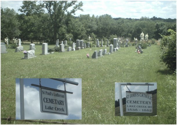
| Description | : | On a farm south of Rt M about 3 miles SE of Bahner, 1/2 mile before M-KK Junction. The original Saint John's Catholic Cemetery adjoins it on the south end. |
frequently asked questions (FAQ):
-
Where is Saint Paul Lutheran Cemetery?
Saint Paul Lutheran Cemetery is located at Lake Creek Pettis County ,Missouri ,USA.
-
Saint Paul Lutheran Cemetery cemetery's updated grave count on graveviews.com?
1 memorials
-
Where are the coordinates of the Saint Paul Lutheran Cemetery?
Latitude: 38.5438995
Longitude: -93.0922012
Nearby Cemetories:
1. Saint John's Catholic Cemetery First
Pettis County, USA
Coordinate: 38.5438700, -93.0922000
2. Deppeler Cemetery
Pettis County, USA
Coordinate: 38.5452300, -93.0902700
3. Lamb Cemetery
Pettis County, USA
Coordinate: 38.5611000, -93.0761032
4. Saint John's Catholic Cemetery
Bahner, Pettis County, USA
Coordinate: 38.5686400, -93.1287400
5. Lake Creek Cemetery
Pettis County, USA
Coordinate: 38.5816994, -93.0793991
6. Holy Cross Cemetery
Cole Camp, Benton County, USA
Coordinate: 38.5052986, -93.1007996
7. Holy Cross Cemetery First
Cole Camp, Benton County, USA
Coordinate: 38.5014100, -93.1120600
8. Lone Star Cemetery
Pettis County, USA
Coordinate: 38.5952988, -93.1382980
9. Pyrmont Lutheran Cemetery ELCA
Stover, Morgan County, USA
Coordinate: 38.5091500, -93.0192700
10. Pyrmont Lutheran Cemetery LCMS
Pyrmont, Morgan County, USA
Coordinate: 38.5053900, -93.0154900
11. Brauersville Immanuel Lutheran Cemetery
Cole Camp, Benton County, USA
Coordinate: 38.4677400, -93.1198600
12. Flat Creek Baptist Cemetery
Sedalia, Pettis County, USA
Coordinate: 38.6303000, -93.1332800
13. Oakridge Mennonite Cemetery
Florence, Morgan County, USA
Coordinate: 38.5808300, -92.9747700
14. Florence Union Cemetery
Florence, Morgan County, USA
Coordinate: 38.5876100, -92.9779200
15. Florence United Methodist Cemetery
Morgan County, USA
Coordinate: 38.5868200, -92.9772900
16. United Church Of Christ Cemetery
Florence, Morgan County, USA
Coordinate: 38.5863200, -92.9768700
17. Homan Family Cemetery
Florence, Morgan County, USA
Coordinate: 38.5890000, -92.9780000
18. Haw Creek Cemetery
Benton County, USA
Coordinate: 38.4431400, -93.0961300
19. Saint Patricks Catholic Cemetery
Spring Fork, Pettis County, USA
Coordinate: 38.5887300, -93.2137500
20. Hinken Cemetery
Morgan County, USA
Coordinate: 38.4796982, -92.9796982
21. Asbury Good-Knight Cemetery
Pettis County, USA
Coordinate: 38.6155500, -93.1986100
22. Bethlehem Baptist Cemetery
Florence, Morgan County, USA
Coordinate: 38.6316500, -93.0042500
23. Trinity Lutheran Cemetery
Cole Camp, Benton County, USA
Coordinate: 38.4714012, -93.2018967
24. Eickhoff Cemetery
Cole Camp, Benton County, USA
Coordinate: 38.4707600, -93.2017300