
| Memorials | : | 0 |
| Location | : | Cambria, San Luis Obispo County, USA |
| Phone | : | (805) 927-3239 |
| Website | : | www.stpaulscambria.org/index.html |
| Coordinate | : | 35.5575200, -121.0757200 |
frequently asked questions (FAQ):
-
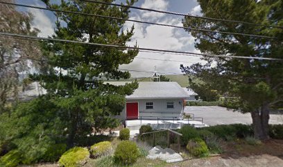
Where is Saint Pauls Episcopal Church Memorial Garden?
Saint Pauls Episcopal Church Memorial Garden is located at 2700 Elton Road Cambria, San Luis Obispo County ,California , 93428USA.
-
Saint Pauls Episcopal Church Memorial Garden cemetery's updated grave count on graveviews.com?
0 memorials
-
Where are the coordinates of the Saint Pauls Episcopal Church Memorial Garden?
Latitude: 35.5575200
Longitude: -121.0757200
Nearby Cemetories:
1. Santa Rosa Cemetery
Cambria, San Luis Obispo County, USA
Coordinate: 35.5662900, -121.0809300
2. Cambria Cemetery
Cambria, San Luis Obispo County, USA
Coordinate: 35.5746994, -121.0922012
3. Porte Family Cemetery
San Simeon, San Luis Obispo County, USA
Coordinate: 35.6376400, -121.0379800
4. Adelaida Cemetery
Adelaida, San Luis Obispo County, USA
Coordinate: 35.5632085, -120.8956170
5. Adelaida Cemetery
San Luis Obispo County, USA
Coordinate: 35.6563988, -120.8728027
6. Cayucos-Morro Bay District Cemetery
Cayucos, San Luis Obispo County, USA
Coordinate: 35.4371986, -120.8850021
7. Willow Creek Mennonite Cemetery
Wilson Corner, San Luis Obispo County, USA
Coordinate: 35.5890410, -120.8215860
8. Sands Cemetery
Bryson, Monterey County, USA
Coordinate: 35.7981840, -121.0882190
9. San Marcos Mennonite Cemetery
San Luis Obispo County, USA
Coordinate: 35.6874570, -120.7995160
10. St. Peter’s By-the-Sea Episcopal Church Memo
Morro Bay, San Luis Obispo County, USA
Coordinate: 35.3628700, -120.8467400
11. Templeton Cemetery
Templeton, San Luis Obispo County, USA
Coordinate: 35.5714455, -120.7022095
12. Canet Cemetery
San Luis Obispo County, USA
Coordinate: 35.3522840, -120.7901660
13. Pleyto Cemetery
Monterey County, USA
Coordinate: 35.8645248, -121.0176468
14. Paso Robles District Cemetery
Paso Robles, San Luis Obispo County, USA
Coordinate: 35.6424700, -120.7035000
15. Saint James Episcopal Church Inurnment Garden
Paso Robles, San Luis Obispo County, USA
Coordinate: 35.6283460, -120.6929780
16. Chapel of the Roses Cemetery
Atascadero, San Luis Obispo County, USA
Coordinate: 35.5027340, -120.6881430
17. Los Osos Valley Memorial Park
Los Osos, San Luis Obispo County, USA
Coordinate: 35.3053017, -120.8011017
18. Atascadero Pine Mountain Cemetery
Atascadero, San Luis Obispo County, USA
Coordinate: 35.4960835, -120.6565582
19. San Miguel District Cemetery
San Miguel, San Luis Obispo County, USA
Coordinate: 35.7392006, -120.7013550
20. Hames Valley Cemetery
Bradley, Monterey County, USA
Coordinate: 35.8644660, -120.8505700
21. Mission San Miguel Cemetery
San Miguel, San Luis Obispo County, USA
Coordinate: 35.7452610, -120.6977370
22. Dove Cemetery
San Luis Obispo County, USA
Coordinate: 35.4482231, -120.6344299
23. Gillett Family Cemetery
Lockwood, Monterey County, USA
Coordinate: 35.9362144, -121.0729828
24. Estrella Adobe Cemetery
Paso Robles, San Luis Obispo County, USA
Coordinate: 35.6975080, -120.6399460