
| Memorials | : | 118 |
| Location | : | Toledo, Lucas County, USA |
| Coordinate | : | 41.6359700, -83.5843400 |
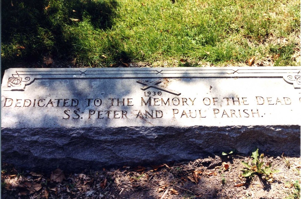
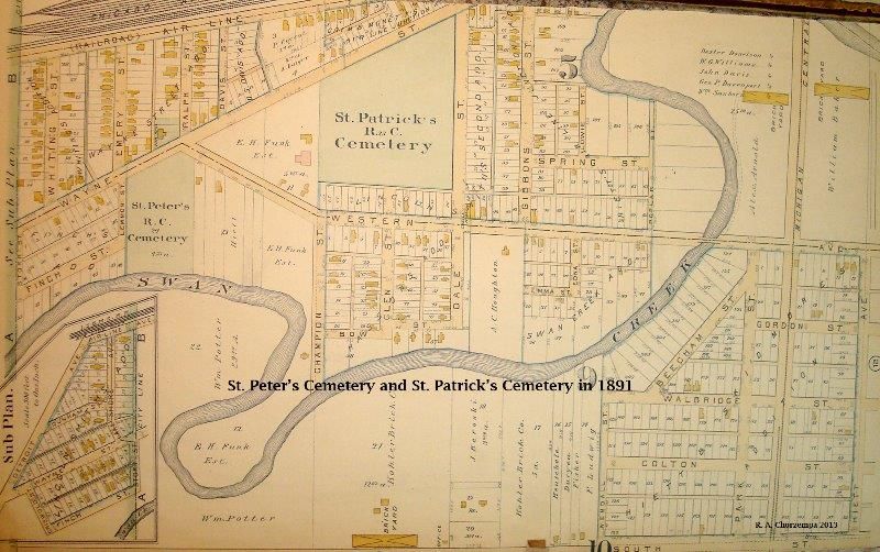
| Description | : | The graves from St. Peter's Cemetery were moved in 1930 to Calvary. The first burial in the parish cemetery was on March 19, 1867 and the last burial was on Nov. 3, 1923. Located at the crossroads of Western Ave. and Wayne St. in Toledo, the city felt that the land would be better used to enhance traffic flow at that intersection. So, in 1928 the city purchased the cemetery land in order to 'round the corner connecting the two streets'. In 1930, some disinterred burials were moved to family plots in Calvary Cemetery. Other burials went unclaimed, or were unable... Read More |
frequently asked questions (FAQ):
-
Where is Saint Peters Cemetery (Defunct)?
Saint Peters Cemetery (Defunct) is located at near the intersection of Airport Hwy, Ralph, Wayne & Western Aves. Toledo, Lucas County ,Ohio ,USA.
-
Saint Peters Cemetery (Defunct) cemetery's updated grave count on graveviews.com?
113 memorials
-
Where are the coordinates of the Saint Peters Cemetery (Defunct)?
Latitude: 41.6359700
Longitude: -83.5843400
Nearby Cemetories:
1. Saint Patricks Catholic Cemetery (Defunct)
Toledo, Lucas County, USA
Coordinate: 41.6376880, -83.5797440
2. Toledo State Hospital Old Cemetery
Toledo, Lucas County, USA
Coordinate: 41.6242200, -83.6021600
3. Sunshine Cemetery (Defunct)
Toledo, Lucas County, USA
Coordinate: 41.6192110, -83.5963720
4. Unnamed Cemetery #2 (Defunct)
Toledo, Lucas County, USA
Coordinate: 41.6527740, -83.5971170
5. Calvary Cemetery
Toledo, Lucas County, USA
Coordinate: 41.6561012, -83.5978012
6. Monastery of the Visitation Cemetery
Toledo, Lucas County, USA
Coordinate: 41.6584560, -83.5954280
7. Caswell Cemetery
Rossford, Wood County, USA
Coordinate: 41.6146180, -83.5672210
8. Toledo State Hospital New Cemetery
Toledo, Lucas County, USA
Coordinate: 41.6171048, -83.6135627
9. Maplewood Cemetery
Toledo, Lucas County, USA
Coordinate: 41.6241110, -83.6245500
10. Anshai Sfard Cemetery
Rossford, Wood County, USA
Coordinate: 41.6043700, -83.5736600
11. Toledo Hebrew Cemetery
Rossford, Wood County, USA
Coordinate: 41.6040550, -83.5741780
12. Unnamed Cemetery #1 (Defunct)
Toledo, Lucas County, USA
Coordinate: 41.6570280, -83.5463600
13. Trinity Episcopal Columbarium
Toledo, Lucas County, USA
Coordinate: 41.6527470, -83.5331560
14. Woodlawn Cemetery
Toledo, Lucas County, USA
Coordinate: 41.6800003, -83.5792007
15. Unnamed Cemetery #4 (Defunct)
Toledo, Lucas County, USA
Coordinate: 41.6434540, -83.5252720
16. Saint Andrews Episcopal Church Columbarium
Toledo, Lucas County, USA
Coordinate: 41.6784040, -83.6103680
17. Unnamed Cemetery #3 (Defunct)
Toledo, Lucas County, USA
Coordinate: 41.6663240, -83.5334060
18. Haughton Cemetery
Toledo, Lucas County, USA
Coordinate: 41.6777992, -83.6216965
19. Forest Cemetery
Toledo, Lucas County, USA
Coordinate: 41.6693130, -83.5293320
20. Collingwood Cemetery
Toledo, Lucas County, USA
Coordinate: 41.6897011, -83.5610962
21. Mount Carmel Cemetery
Toledo, Lucas County, USA
Coordinate: 41.6861000, -83.5453033
22. Joy Cemetery
Ottawa Hills, Lucas County, USA
Coordinate: 41.6656100, -83.6535500
23. Saint Michaels In The Hills Memorial Garden
Toledo, Lucas County, USA
Coordinate: 41.6653700, -83.6545390
24. Ottawa Hills Memorial Park
Toledo, Lucas County, USA
Coordinate: 41.6805992, -83.6408005