
| Memorials | : | 0 |
| Location | : | Sandnessjoen, Alstahaug kommune, Norway |
| Coordinate | : | 66.0140735, 12.6260426 |
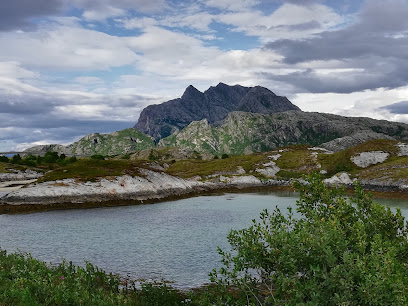
| Description | : | When time the oldest part of Sandnes cemetery came into use, I have not found answers to - nor anything regarding Sandnes chapel. The cemetery is surrounded by Fylkesveg 17, Kystriksvegen, on one side and Sandneselva on the other. In the southwest, Sju søstre (the Seven Sisters) mountain range is located and forms a great sight for visitors. The oldest part of the cemetery is 20.3 dekar / 5.02 acres (US / UK). In the years 2013 - 2015, an extension of the cemetery was made, as well as renovation of the old part. The new... Read More |
frequently asked questions (FAQ):
-
Where is Sandnes kirkegård?
Sandnes kirkegård is located at Harald Hårfagres gate 40 Sandnessjoen, Alstahaug kommune ,Nordland fylke , 8803Norway.
-
Sandnes kirkegård cemetery's updated grave count on graveviews.com?
0 memorials
-
Where are the coordinates of the Sandnes kirkegård?
Latitude: 66.0140735
Longitude: 12.6260426
Nearby Cemetories:
1. Herøy Church Cemetery
Herøy kommune, Norway
Coordinate: 65.9732920, 12.2783250
2. Alstahaug Church Cemetery
Alstahaug, Alstahaug kommune, Norway
Coordinate: 65.8935110, 12.3991990
3. Løkta gravplass
Nesna kommune, Norway
Coordinate: 66.1776443, 12.7274176
4. Dønnes Church Cemetery
Donnes, Dønna kommune, Norway
Coordinate: 66.2034210, 12.5866100
5. Tjøtta Soviet War Cemetery
Tjotta, Alstahaug kommune, Norway
Coordinate: 65.8453476, 12.3938890
6. Husby Kirkegård
Nesna kommune, Norway
Coordinate: 66.2254894, 12.7658772
7. Aust-Tomma hjelpekirkegård
Nesna kommune, Norway
Coordinate: 66.2395028, 12.8554883
8. Nesna ved kirken
Nesna, Nesna kommune, Norway
Coordinate: 66.2005552, 13.0251207
9. Nesna kirkegard
Nesna, Nesna kommune, Norway
Coordinate: 66.1999100, 13.0364200
10. Visthus
Visthus, Vevelstad kommune, Norway
Coordinate: 65.7326960, 12.5933830
11. Dolstad Kirke
Mosjoen, Vefsn kommune, Norway
Coordinate: 65.8449360, 13.2035590
12. Mosjøen Kapell Cemetery
Mosjoen, Vefsn kommune, Norway
Coordinate: 65.8389587, 13.2066603
13. Vevelstad Kirke
Vevelstad, Vevelstad kommune, Norway
Coordinate: 65.7089000, 12.4551000
14. Ylvingen kirkegård
Ylvingen, Vega kommune, Norway
Coordinate: 65.6369834, 12.1702984
15. Vega kirkegården
Gladstad, Vega kommune, Norway
Coordinate: 65.6756854, 11.9620992
16. Hemnes Cemetery
Hemnesberget, Hemnes kommune, Norway
Coordinate: 66.2277860, 13.6164320
17. Krokselmoen
Hemnes kommune, Norway
Coordinate: 65.9500977, 13.7985281
18. Korgen Nye Kirkegård
Korgen, Hemnes kommune, Norway
Coordinate: 66.0765930, 13.8247170
19. Korgen øvre Kirkegård
Korgen, Hemnes kommune, Norway
Coordinate: 66.0769530, 13.8261220
20. Korgen nedre kirkegård
Korgen, Hemnes kommune, Norway
Coordinate: 66.0775500, 13.8278600
21. Bjerka øvre
Bjerka, Hemnes kommune, Norway
Coordinate: 66.1540260, 13.8576180
22. Grane Church
Grane kommune, Norway
Coordinate: 65.5831210, 13.3967580
23. Rødøyvika Cemetery (gravgård)
Rodoy, Rødøy kommune, Norway
Coordinate: 66.6605000, 13.0787000
24. Mo I Rana Churchyard
Mo i Rana, Rana kommune, Norway
Coordinate: 66.3099600, 14.1436480