
| Memorials | : | 0 |
| Location | : | Sandridge, Berkeley County, USA |
| Coordinate | : | 33.2397003, -80.3032990 |
frequently asked questions (FAQ):
-
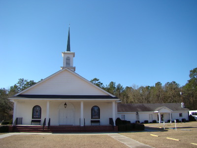
Where is Sandridge First Baptist Church Cemetery?
Sandridge First Baptist Church Cemetery is located at 4677 State Road Sandridge, Berkeley County ,South Carolina ,USA.
-
Sandridge First Baptist Church Cemetery cemetery's updated grave count on graveviews.com?
0 memorials
-
Where are the coordinates of the Sandridge First Baptist Church Cemetery?
Latitude: 33.2397003
Longitude: -80.3032990
Nearby Cemetories:
1. Springhill United Methodist Church Cemetery
Berkeley County, USA
Coordinate: 33.2311000, -80.3255997
2. Ebenezer-Zion AME Church Cemetery
Sandridge, Berkeley County, USA
Coordinate: 33.2571630, -80.3244780
3. Poplar Hill Christian Church Cemetery
Cross, Berkeley County, USA
Coordinate: 33.2555512, -80.2581640
4. Blaco Creek Cemetery
Berkeley County, USA
Coordinate: 33.2853012, -80.2583008
5. Black Creek United Methodist Church Cemetery
Cross, Berkeley County, USA
Coordinate: 33.2857710, -80.2578200
6. Bethel United Methodist Church Cemetery
Harleyville, Dorchester County, USA
Coordinate: 33.1993710, -80.3573340
7. Mims Lake Cemetery
Pringletown, Berkeley County, USA
Coordinate: 33.1697006, -80.3011017
8. Bethany-Breland Cemetery
Holly Hill, Orangeburg County, USA
Coordinate: 33.2885910, -80.3646680
9. Briner Christian Church Cemetery
Holly Hill, Orangeburg County, USA
Coordinate: 33.2905110, -80.3637790
10. Mizell Cemetery
Sandridge, Berkeley County, USA
Coordinate: 33.1657530, -80.2993360
11. Small Pines Family Cemetery
Harleyville, Dorchester County, USA
Coordinate: 33.1734320, -80.3481410
12. Grooms Cemetery
Cross, Berkeley County, USA
Coordinate: 33.2803001, -80.2213974
13. Moorer Vogt Cemetery
Harleyville, Dorchester County, USA
Coordinate: 33.2450850, -80.3985460
14. Lovely Hill Church Cemetery
Eutawville, Orangeburg County, USA
Coordinate: 33.2963800, -80.3744200
15. Saint Daniel United Methodist Church
Harleyville, Dorchester County, USA
Coordinate: 33.2030380, -80.3940050
16. Cain Run Cemetery
Eutawville, Orangeburg County, USA
Coordinate: 33.3255630, -80.3155000
17. New Galilee Christian Church Cemetery
Holly Hill, Orangeburg County, USA
Coordinate: 33.3145750, -80.3584290
18. Pressley Cemetery
Berkeley County, USA
Coordinate: 33.3177986, -80.2510986
19. Wampee Plantation Tract
Eutawville, Orangeburg County, USA
Coordinate: 33.2255830, -80.1901140
20. Martin Cemetery
Eutawville, Orangeburg County, USA
Coordinate: 33.3348170, -80.3390500
21. Greater Life Tabernacle
Holly Hill, Orangeburg County, USA
Coordinate: 33.2925250, -80.4046260
22. New Jerusalem Baptist Church Ct
Holly Hill, Orangeburg County, USA
Coordinate: 33.3121350, -80.3899460
23. Old Harley Cemetery
Harleyville, Dorchester County, USA
Coordinate: 33.1473812, -80.3648153
24. Limestone Baptist Church Cemetery
Dorchester, Dorchester County, USA
Coordinate: 33.1472015, -80.3649979