
| Memorials | : | 0 |
| Location | : | Upper Sandusky, Wyandot County, USA |
| Coordinate | : | 40.8347220, -83.2663890 |
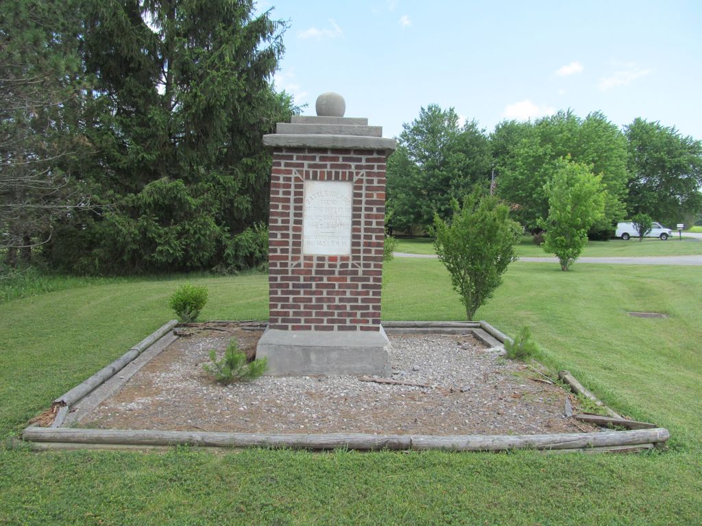
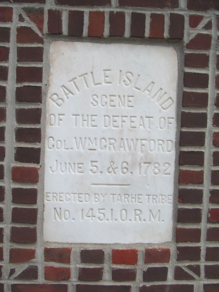
| Description | : | "The battle of sandusky was fought in and around the grove known as "Battle Island, " in what is now Crane Township, Wyandot county, three miles north, and half a mile east, of the courthouse in Upper sandusly. This spot has balways been readily identifed, by reason of the scars upon the trunks of the trees, made by the hachets of the Indians in getting out the bullets after the action. But the "Island" may now said to have disappeared. Cultivated fields mark the spot where the contest took place. Occasionally an interesting relic is turned up by the plowshare,... Read More |
frequently asked questions (FAQ):
-
Where is Sandusky Battlefield?
Sandusky Battlefield is located at Upper Sandusky, Wyandot County ,Ohio ,USA.
-
Sandusky Battlefield cemetery's updated grave count on graveviews.com?
0 memorials
-
Where are the coordinates of the Sandusky Battlefield?
Latitude: 40.8347220
Longitude: -83.2663890

Nearby Cemetories:
1. Old Mission Cemetery
Upper Sandusky, Wyandot County, USA
Coordinate: 40.8356000, -83.2796300
2. Old Indian Burial Grounds
Upper Sandusky, Wyandot County, USA
Coordinate: 40.8265540, -83.2779740
3. Saint Peters Catholic Cemetery
Upper Sandusky, Wyandot County, USA
Coordinate: 40.8375015, -83.2855988
4. Peters Cemetery
Upper Sandusky, Wyandot County, USA
Coordinate: 40.8122220, -83.2794440
5. Nine Oaks Cemetery
Upper Sandusky, Wyandot County, USA
Coordinate: 40.8472716, -83.2973859
6. Chief Tarhe Monument
Upper Sandusky, Wyandot County, USA
Coordinate: 40.8619310, -83.2673790
7. Haas Cemetery
Upper Sandusky, Wyandot County, USA
Coordinate: 40.8259090, -83.2288750
8. Upper Sandusky Mausoleum
Wyandot County, USA
Coordinate: 40.8077030, -83.2843710
9. Rock Run Cemetery
Upper Sandusky, Wyandot County, USA
Coordinate: 40.8217010, -83.2225037
10. Oak Hill Cemetery
Upper Sandusky, Wyandot County, USA
Coordinate: 40.7952995, -83.2758026
11. Reber Cemetery
Upper Sandusky, Wyandot County, USA
Coordinate: 40.7937600, -83.2672450
12. McClain Cemetery
Upper Sandusky, Wyandot County, USA
Coordinate: 40.7846929, -83.2419017
13. Salem Cemetery
Eden Township, Wyandot County, USA
Coordinate: 40.8408230, -83.1929050
14. Ulrich Cemetery
Wyandot County, USA
Coordinate: 40.8480988, -83.1913986
15. Smithville Cemetery
Smithville, Wyandot County, USA
Coordinate: 40.8914500, -83.2368600
16. Infirmary Cemetery
Upper Sandusky, Wyandot County, USA
Coordinate: 40.8795400, -83.3221470
17. Emanuel United Church of Christ Cemetery
Upper Sandusky, Wyandot County, USA
Coordinate: 40.7897980, -83.2073110
18. Gilliland Cemetery
Edenville, Wyandot County, USA
Coordinate: 40.8331100, -83.1793600
19. Union Church Cemetery
Upper Sandusky, Wyandot County, USA
Coordinate: 40.8774185, -83.1894226
20. North Salem Lutheran Church Cemetery
Upper Sandusky, Wyandot County, USA
Coordinate: 40.8756100, -83.3471400
21. Saint Joseph's Cemetery
Lovell, Wyandot County, USA
Coordinate: 40.8767200, -83.3574200
22. Hendrickson Cemetery
Upper Sandusky, Wyandot County, USA
Coordinate: 40.7667236, -83.3243637
23. Krock Cemetery
Kirby, Wyandot County, USA
Coordinate: 40.8227997, -83.3806000
24. Stalter Cemetery
Belle Vernon, Wyandot County, USA
Coordinate: 40.9203260, -83.2415822