
| Memorials | : | 4 |
| Location | : | Sandy Hill, Ottawa Municipality, Canada |
| Coordinate | : | 45.4342520, -75.6774440 |
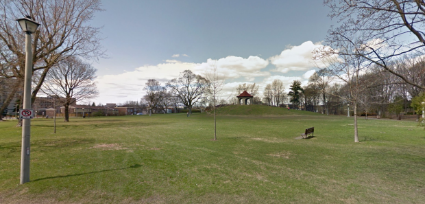
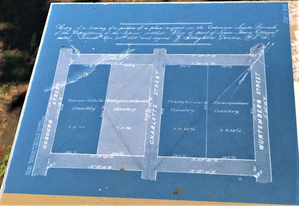
| Description | : | Sandy Hill Cemetery opened in Lower Town in 1844 on land granted by the Ordnance Department. Some remains from the earlier Barrack's Hill Cemetery were transferred here after it opened. It was closed to burials in 1878 and starting about 1873 many of the remains interred there were transferred, mostly to the then new Beechwood and Notre Dame Cemeteries. The land lay idle for many years. In 1911 the city of Ottawa recorded the monuments that were still remaining and the land became McDonald Gardens park and is bounded by Cobourg and Wurtemburg streets. There were four sections to the... Read More |
frequently asked questions (FAQ):
-
Where is Sandy Hill Cemetery?
Sandy Hill Cemetery is located at Sandy Hill, Ottawa Municipality ,Ontario ,Canada.
-
Sandy Hill Cemetery cemetery's updated grave count on graveviews.com?
4 memorials
-
Where are the coordinates of the Sandy Hill Cemetery?
Latitude: 45.4342520
Longitude: -75.6774440

Nearby Cemetories:
1. Saint Bartholomew's Anglican Church
New Edinburgh, Ottawa Municipality, Canada
Coordinate: 45.4422790, -75.6878390
2. Old Nicholas Street Gaol
Sandy Hill, Ottawa Municipality, Canada
Coordinate: 45.4247820, -75.6887180
3. Ottawa Cremation Memorial
Ottawa, Ottawa Municipality, Canada
Coordinate: 45.4455300, -75.6693220
4. Basilique-Cathédrale Notre-Dame
Ottawa, Ottawa Municipality, Canada
Coordinate: 45.4296720, -75.6964970
5. Oratoire Soeurs de la Charité d'Ottawa
Ottawa, Ottawa Municipality, Canada
Coordinate: 45.4317890, -75.6975640
6. Beechwood Cemetery
Ottawa, Ottawa Municipality, Canada
Coordinate: 45.4462624, -75.6660538
7. Ottawa Memorial
Ottawa, Ottawa Municipality, Canada
Coordinate: 45.4408000, -75.6960700
8. National War Memorial
Ottawa, Ottawa Municipality, Canada
Coordinate: 45.4240360, -75.6954970
9. Notre-Dame of Ottawa Cemetery
Ottawa, Ottawa Municipality, Canada
Coordinate: 45.4419708, -75.6498871
10. Servantes de Jésus-Marie
Gatineau, Outaouais Region, Canada
Coordinate: 45.4367800, -75.7084200
11. Cimetière Notre-Dame
Gatineau, Outaouais Region, Canada
Coordinate: 45.4488690, -75.7139450
12. Cimetière Saint-François-de-Sales
Gatineau, Outaouais Region, Canada
Coordinate: 45.4619000, -75.7045900
13. Saint James Cemetery
Gatineau, Outaouais Region, Canada
Coordinate: 45.4230020, -75.7366240
14. Billings Burial Ground
Billings Bridge, Ottawa Municipality, Canada
Coordinate: 45.3898610, -75.6718890
15. Cimetière Saint-Rédempteur
Gatineau, Outaouais Region, Canada
Coordinate: 45.4439000, -75.7519500
16. Cimetière Saint-Jean-Marie-Vianney
Gatineau, Outaouais Region, Canada
Coordinate: 45.4878630, -75.6393890
17. Cimetière Familial Barber
Gatineau, Outaouais Region, Canada
Coordinate: 45.5011003, -75.7024885
18. Cimetière West Templeton
Gatineau, Outaouais Region, Canada
Coordinate: 45.5037410, -75.7008210
19. Templeton United Church Cemetery
Gatineau, Outaouais Region, Canada
Coordinate: 45.4864500, -75.6018100
20. Saint George's Hawthorne Cemetery
Ottawa, Ottawa Municipality, Canada
Coordinate: 45.3849200, -75.5960000
21. Cimetiere du College Saint Alexandre
Gatineau, Outaouais Region, Canada
Coordinate: 45.4941331, -75.7494254
22. Cimetière Bellevue
Gatineau, Outaouais Region, Canada
Coordinate: 45.4074290, -75.7858860
23. Cimetière Sainte-Rose-de-Lima
Gatineau, Outaouais Region, Canada
Coordinate: 45.4990230, -75.6065230
24. Cimetière Saint-Alexandre
Gatineau, Outaouais Region, Canada
Coordinate: 45.4992600, -75.7536700