
| Memorials | : | 0 |
| Location | : | Meiningen, Landkreis Schmalkalden-Meiningen, Germany |
| Coordinate | : | 50.5708980, 10.4130330 |
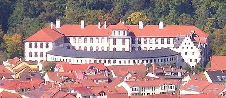
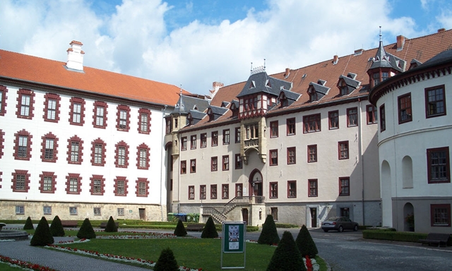
| Description | : | Address: Schloss Elisabethenburg Meininger Museen / Kulturstiftung Meiningen Postal Box #100554 98605 Meiningen Tele: 0 36 93 / 50 36 41 Fax: 0 36 93 / 50 36 44 The castle Elisabethenburg was built between 1682 and 1692. The crypt under the castle church is the final resting place for some members of the noble House Sachsen-Meiningen. The castle was this family's residence until 1918. Another burial place for this family is the Parkfriedhof Meiningen. |
frequently asked questions (FAQ):
-
Where is Schlosskirche Elisabethenburg in Meiningen?
Schlosskirche Elisabethenburg in Meiningen is located at Schlossplatz 1 Meiningen, Landkreis Schmalkalden-Meiningen ,Thüringen , 98605Germany.
-
Schlosskirche Elisabethenburg in Meiningen cemetery's updated grave count on graveviews.com?
0 memorials
-
Where are the coordinates of the Schlosskirche Elisabethenburg in Meiningen?
Latitude: 50.5708980
Longitude: 10.4130330
Nearby Cemetories:
1. Parkfriedhof Meiningen
Meiningen, Landkreis Schmalkalden-Meiningen, Germany
Coordinate: 50.5675000, 10.4216670
2. Friedhof Walldorf
Walldorf, Landkreis Schmalkalden-Meiningen, Germany
Coordinate: 50.6140810, 10.3849670
3. Friedhof Eußenhausen
Eussenhausen, Landkreis Rhön-Grabfeld, Germany
Coordinate: 50.4656114, 10.3163383
4. Viernau Friedhof
Viernau, Landkreis Schmalkalden-Meiningen, Germany
Coordinate: 50.6628700, 10.5601710
5. Parkfriedhof
Mellrichstadt, Landkreis Rhön-Grabfeld, Germany
Coordinate: 50.4295222, 10.3136086
6. Alter Friedhof
Mellrichstadt, Landkreis Rhön-Grabfeld, Germany
Coordinate: 50.4305519, 10.3040414
7. Hauptfriedhof Suhl
Suhl, Stadtkreis Suhl, Germany
Coordinate: 50.6046800, 10.6948200
8. Friedhof Oberstreu
Oberstreu, Landkreis Rhön-Grabfeld, Germany
Coordinate: 50.4036094, 10.2854267
9. Friedhof Herrenbreitungen
Benshausen, Landkreis Schmalkalden-Meiningen, Germany
Coordinate: 50.7569660, 10.3438060
10. Stadtkirche St. Johannis
Ahlstadt, Landkreis Hildburghausen, Germany
Coordinate: 50.5166670, 10.7500000
11. Sankt Johanniskirche
Schleusingen, Landkreis Hildburghausen, Germany
Coordinate: 50.5094100, 10.7503400
12. Katholischer Friedhof Dermbach
Dermbach, Wartburgkreis, Germany
Coordinate: 50.7179797, 10.1157702
13. Friedhof Unteralba
Unteralba, Wartburgkreis, Germany
Coordinate: 50.7228908, 10.1119555
14. Friedhof Hildburghausen
Hildburghausen, Landkreis Hildburghausen, Germany
Coordinate: 50.4334170, 10.7326670
15. Friedhof Wülfershausen a. d. Saale
Wülfershausen, Landkreis Rhön-Grabfeld, Germany
Coordinate: 50.3278580, 10.3396200
16. Findelbergfriedhof
Saal an der Saale, Landkreis Rhön-Grabfeld, Germany
Coordinate: 50.3216960, 10.3570760
17. Gleicherwiesen Friedhof
Gleicherwiesen, Landkreis Hildburghausen, Germany
Coordinate: 50.3612868, 10.6359394
18. Jüdischer Friedhof Tann
Tann, Landkreis Fulda, Germany
Coordinate: 50.6465420, 10.0251860
19. Friedhof Schweina
Schweina, Wartburgkreis, Germany
Coordinate: 50.8262100, 10.3341480
20. Kath. Pfarramt St. Nikolaus Herschfeld
Herschfeld, Landkreis Rhön-Grabfeld, Germany
Coordinate: 50.3297625, 10.2385014
21. Husenfriedhof
Bad Salzungen, Wartburgkreis, Germany
Coordinate: 50.8126213, 10.2198917
22. Friedhof Bad Königshofen im Grabfeld
Bad Konigshofen im Grabfeld, Landkreis Rhön-Grabfeld, Germany
Coordinate: 50.2982487, 10.4613716
23. Jüdischer Friedhof
Bad Neustadt an der Saale, Landkreis Rhön-Grabfeld, Germany
Coordinate: 50.3212800, 10.2014220
24. Friedhof Finsterbergen
Finsterbergen, Landkreis Gotha, Germany
Coordinate: 50.8366529, 10.5914414