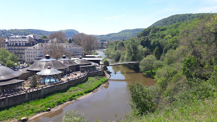
| Memorials | : | 0 |
| Location | : | Bad Kreuznach, Landkreis Bad Kreuznach, Germany |
| Coordinate | : | 49.8500000, 7.8666670 |
| Description | : | Schwarz-Kloster (Black Abbey aka Monastery to Saint Nicholas), was a monastery of the Carmelites in Kreuznach in today's District Bad Kreuznach in Rhineland-Palatinate, that existed from 1281 to 1802. |
frequently asked questions (FAQ):
-
Where is Schwarz-Kloster?
Schwarz-Kloster is located at Bad Kreuznach, Landkreis Bad Kreuznach ,Rheinland-Pfalz ,Germany.
-
Schwarz-Kloster cemetery's updated grave count on graveviews.com?
0 memorials
-
Where are the coordinates of the Schwarz-Kloster?
Latitude: 49.8500000
Longitude: 7.8666670
Nearby Cemetories:
1. Nikolauskirche
Bad Kreuznach, Landkreis Bad Kreuznach, Germany
Coordinate: 49.8466700, 7.8561000
2. Pauluskirche
Bad Kreuznach, Landkreis Bad Kreuznach, Germany
Coordinate: 49.8443550, 7.8568340
3. Hauptfriedhof Bad Kreuznach
Bad Kreuznach, Landkreis Bad Kreuznach, Germany
Coordinate: 49.8367900, 7.8729980
4. Friedhof Winzenheim
Winzenheim, Landkreis Bad Kreuznach, Germany
Coordinate: 49.8719134, 7.8608964
5. Jüdischer Friedhof Bretzenheim
Bretzenheim, Landkreis Bad Kreuznach, Germany
Coordinate: 49.8801500, 7.8981800
6. Friedhof Langenlonsheim
Langenlonsheim, Landkreis Bad Kreuznach, Germany
Coordinate: 49.8933884, 7.8967011
7. Stift Pfaffen-Schwabenheim
Pfaffen-Schwabenheim, Landkreis Bad Kreuznach, Germany
Coordinate: 49.8516670, 7.9527780
8. Stiftskirche Pfaffen-Schwabenheim
Pfaffen-Schwabenheim, Landkreis Bad Kreuznach, Germany
Coordinate: 49.8516670, 7.9527780
9. Friedhof Gensingen
Gensingen, Landkreis Mainz-Bingen, Germany
Coordinate: 49.8999951, 7.9233923
10. Evangelische Kirche Windesheim
Windesheim, Landkreis Bad Kreuznach, Germany
Coordinate: 49.9046960, 7.8157110
11. Friedhof Grolsheim
Landkreis Mainz-Bingen, Germany
Coordinate: 49.9069900, 7.9184200
12. Friedhof Wöllstein
Wollstein, Landkreis Alzey-Worms, Germany
Coordinate: 49.8179175, 7.9676952
13. Wöllstein Cemetery
Landkreis Alzey-Worms, Germany
Coordinate: 49.8179545, 7.9679545
14. Friedhof Siefersheim
Siefersheim, Landkreis Alzey-Worms, Germany
Coordinate: 49.7975230, 7.9536323
15. Waldfriedhof Friedwald Niederhausen
Bingert, Landkreis Bad Kreuznach, Germany
Coordinate: 49.7813700, 7.7991500
16. Friedhof Schloßböckelheim
Schlossbockelheim, Landkreis Bad Kreuznach, Germany
Coordinate: 49.8148345, 7.7525011
17. Evangelische Kirche Waldlaubersheim
Waldlaubersheim, Landkreis Bad Kreuznach, Germany
Coordinate: 49.9287820, 7.8334000
18. Wonsheimer Friedhof
Wonsheim, Landkreis Alzey-Worms, Germany
Coordinate: 49.7819008, 7.9687470
19. Duchroth Cemetery
Duchroth, Landkreis Bad Kreuznach, Germany
Coordinate: 49.7844770, 7.7404600
20. Weiler
Weiler bei Bingen, Landkreis Mainz-Bingen, Germany
Coordinate: 49.9559028, 7.8697942
21. Jewish Cemetery
Bingen am Rhein, Landkreis Mainz-Bingen, Germany
Coordinate: 49.9617295, 7.9006683
22. Mörsfeld
Morsfeld, Donnersbergkreis, Germany
Coordinate: 49.7454889, 7.9376517
23. Wendelsheim Cemetery
Wendelsheim, Landkreis Alzey-Worms, Germany
Coordinate: 49.7695416, 7.9979861
24. Kirche Niedermoschel
Niedermoschel, Donnersbergkreis, Germany
Coordinate: 49.7350000, 7.7958330

