
| Memorials | : | 0 |
| Location | : | Jesup, Buchanan County, USA |
| Coordinate | : | 42.3805453, -92.0557342 |
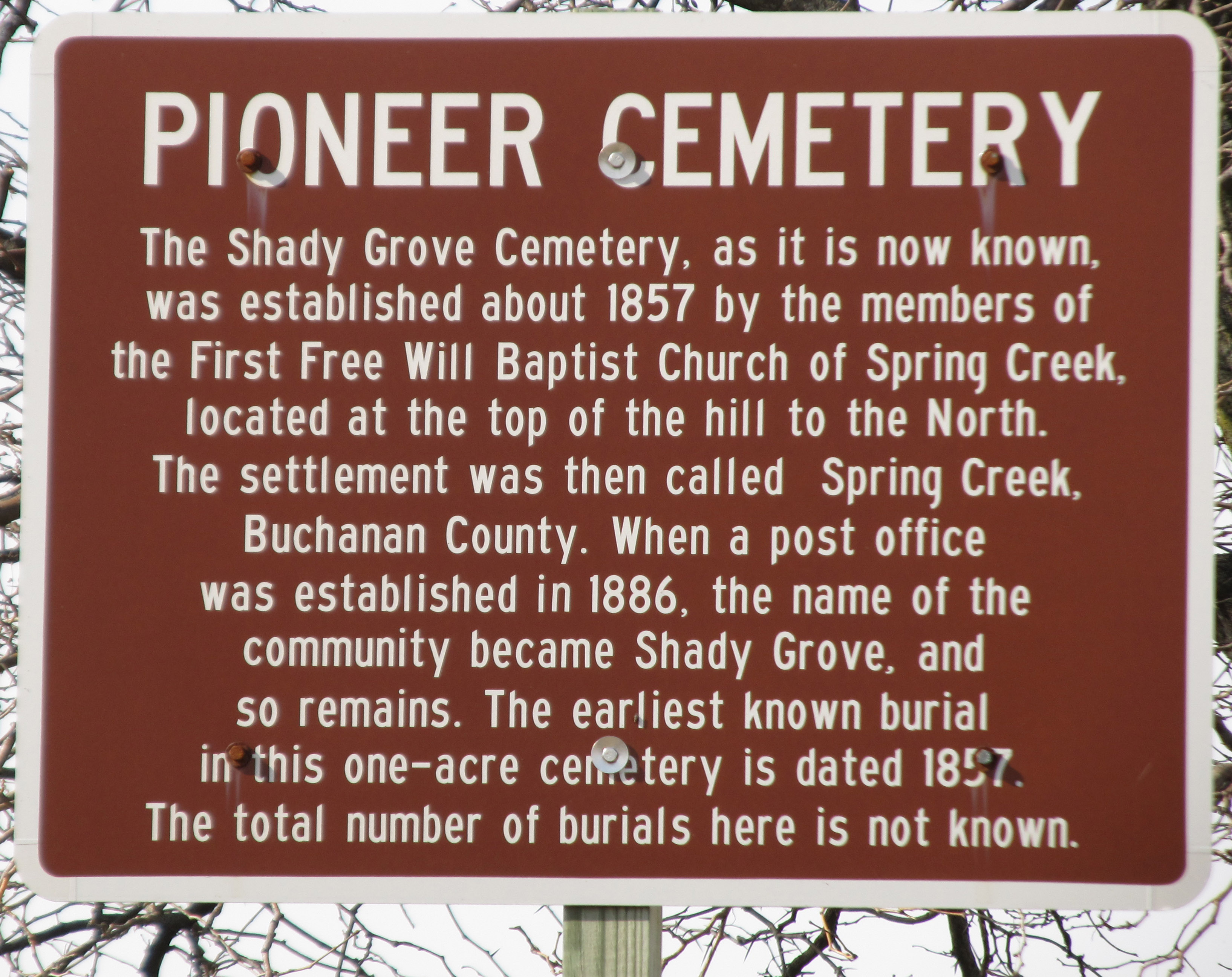
| Description | : | Jefferson Twp Section 6 Abandoned cemetery; there used to be a church established around 1865-1868 and the interments are believed to be part of the membership; the church has since burned down There was a Brown family plot with 4-5 burials and 1 or 2 other family plots with white picket fences around them. |
frequently asked questions (FAQ):
-
Where is Shady Grove Cemetery?
Shady Grove Cemetery is located at Benson Shady Grove Avenue Jesup, Buchanan County ,Iowa , 50648USA.
-
Shady Grove Cemetery cemetery's updated grave count on graveviews.com?
0 memorials
-
Where are the coordinates of the Shady Grove Cemetery?
Latitude: 42.3805453
Longitude: -92.0557342
Nearby Cemetories:
1. Zion Lutheran Jubilee Cemetery
Jubilee, Black Hawk County, USA
Coordinate: 42.3843050, -92.0837440
2. Spring Creek Chapel Cemetery
La Porte City, Black Hawk County, USA
Coordinate: 42.3616982, -92.0783005
3. Brandon Cemetery
Brandon, Buchanan County, USA
Coordinate: 42.3156300, -91.9945200
4. Jefferson Township Cemetery
Brandon, Buchanan County, USA
Coordinate: 42.3139000, -91.9931030
5. Sawyer Cemetery
La Porte City, Black Hawk County, USA
Coordinate: 42.3381004, -92.1519012
6. Beachler Cemetery
Brandon, Buchanan County, USA
Coordinate: 42.3045000, -91.9908000
7. Greenwood Cemetery
Brandon, Buchanan County, USA
Coordinate: 42.3123970, -91.9651640
8. Saint Athanasius Cemetery
Jesup, Buchanan County, USA
Coordinate: 42.4761009, -92.0421982
9. Cedar Crest Cemetery
Jesup, Buchanan County, USA
Coordinate: 42.4782982, -92.0406036
10. Westview Cemetery
La Porte City, Black Hawk County, USA
Coordinate: 42.3107986, -92.1699982
11. Sancta Maria Cemetery
Gilbertville, Black Hawk County, USA
Coordinate: 42.4132560, -92.2060940
12. State Hospital Cemetery
Independence, Buchanan County, USA
Coordinate: 42.4455986, -91.9253006
13. Bear Creek Cemetery
Benton County, USA
Coordinate: 42.2705994, -91.9792023
14. Engledow Cemetery
Mount Auburn, Benton County, USA
Coordinate: 42.2686996, -92.1330032
15. Saint Mary's Cemetery
Gilbertville, Black Hawk County, USA
Coordinate: 42.4188300, -92.2181200
16. Mount Auburn Cemetery
Mount Auburn, Benton County, USA
Coordinate: 42.2536800, -92.0903000
17. New Barclay Cemetery
Black Hawk County, USA
Coordinate: 42.5113983, -92.0982971
18. West Haven Cemetery
Independence, Buchanan County, USA
Coordinate: 42.4588678, -91.8986696
19. Anton Cemetery
La Porte City, Black Hawk County, USA
Coordinate: 42.3418999, -92.2399979
20. Poyner Cemetery
Gilbertville, Black Hawk County, USA
Coordinate: 42.4435900, -92.2298800
21. Mount Hope Cemetery
Independence, Buchanan County, USA
Coordinate: 42.4571991, -91.8914032
22. Oakwood Cemetery
Independence, Buchanan County, USA
Coordinate: 42.4627991, -91.8927994
23. Saint Josephs Cemetery
Raymond, Black Hawk County, USA
Coordinate: 42.4684150, -92.2136660
24. Old Barclay Cemetery
Dunkerton, Black Hawk County, USA
Coordinate: 42.5257988, -92.0939026