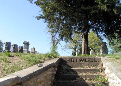
| Memorials | : | 0 |
| Location | : | Richmond, Ray County, USA |
| Coordinate | : | 39.2807999, -93.9850006 |
| Description | : | This is a privately owned cemetery consisting of about one-half acre and was originally the orchard of Jabex Shotwell. The first burial here was that of a little girl who was visiting in the Shotwell home. Mr. Shotwell gave his permission for her to be buried in the orchard, the date - some time after 1835 and before 1841. The first member of the family to be buried here was Ester, the oldest daughter of Jabez Shotwell, 1841. Source: 1973 Ray County History |
frequently asked questions (FAQ):
-
Where is Shotwell Cemetery?
Shotwell Cemetery is located at Richmond, Ray County ,Missouri ,USA.
-
Shotwell Cemetery cemetery's updated grave count on graveviews.com?
0 memorials
-
Where are the coordinates of the Shotwell Cemetery?
Latitude: 39.2807999
Longitude: -93.9850006
Nearby Cemetories:
1. Woodland Cemetery
Richmond, Ray County, USA
Coordinate: 39.2807999, -93.9835968
2. Sunny Slope Cemetery
Richmond, Ray County, USA
Coordinate: 39.2803001, -93.9867020
3. Richmond Cemetery
Richmond, Ray County, USA
Coordinate: 39.2786430, -93.9856550
4. Martin Family Cemetery
Richmond, Ray County, USA
Coordinate: 39.2768200, -93.9899500
5. Pioneer Cemetery
Richmond, Ray County, USA
Coordinate: 39.2849800, -93.9762200
6. Dunn Family Cemetery
Richmond, Ray County, USA
Coordinate: 39.2898500, -93.9816100
7. Ray County Cemetery
Richmond, Ray County, USA
Coordinate: 39.2712380, -93.9907810
8. Cates Cemetery
Richmond, Ray County, USA
Coordinate: 39.2832900, -94.0076500
9. Richmond Memory Gardens
Richmond, Ray County, USA
Coordinate: 39.2771988, -93.9518967
10. Whitmer Cemetery
Richmond, Ray County, USA
Coordinate: 39.2562485, -93.9740067
11. Lile Cemetery
Richmond, Ray County, USA
Coordinate: 39.2881700, -93.9477800
12. Moses Dale Cemetery
Richmond, Ray County, USA
Coordinate: 39.2996500, -94.0157800
13. Gunnell Cemetery
Richmond, Ray County, USA
Coordinate: 39.3072014, -93.9569016
14. Watkins Cemetery
Richmond, Ray County, USA
Coordinate: 39.2633018, -93.9449997
15. Hill Cemetery
Richmond, Ray County, USA
Coordinate: 39.2933006, -93.9419022
16. Murray-Anderson Cemetery
Richmond, Ray County, USA
Coordinate: 39.2631400, -93.9447100
17. Presley Carter Family Cemetery
Richmond, Ray County, USA
Coordinate: 39.2796400, -94.0326300
18. Johnson Cemetery
Richmond, Ray County, USA
Coordinate: 39.3157997, -93.9630966
19. King Cemetery
Richmond, Ray County, USA
Coordinate: 39.2400300, -93.9725100
20. Nutter Cemetery
Richmond, Ray County, USA
Coordinate: 39.2966995, -93.9344025
21. Jacobs Cemetery
Richmond, Ray County, USA
Coordinate: 39.3217010, -94.0064011
22. Cumberland Old Presbyterian Church Cemetery
Richmond, Ray County, USA
Coordinate: 39.3252373, -93.9963837
23. Mount Pleasant Cemetery
Richmond, Ray County, USA
Coordinate: 39.3255997, -93.9972000
24. Todds Chapel Cemetery
Richmond, Ray County, USA
Coordinate: 39.2864000, -94.0448000

