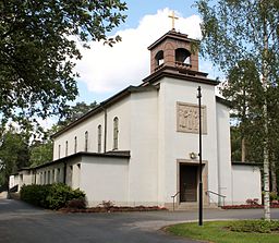
| Memorials | : | 0 |
| Location | : | Växjö, Växjö kommun, Sweden |
| Coordinate | : | 56.5314680, 14.4846120 |
| Description | : | Skogslyckan Kyrkogard is located north of central Vaxjo in Kronobergs Lan, Smaland, Sweden. This cemetery was planned in the early 1900s, as Tegner Cemetery was no longer large enough to serve the city's needs. The congregation of what in English is known as Forest Lyckan Cemetery, purchased eight acres of land in 1926. The design of the cemetery was originated by county architect, Signature Bergentz, and later modified by county architect, Olof Lundgren. It took over ten years to build the cemetery, beginning in 1932, and ending with the inauguration on June 6, 1943. The character of... Read More |
frequently asked questions (FAQ):
-
Where is Skogslyckans Kyrkogard?
Skogslyckans Kyrkogard is located at Växjö, Växjö kommun ,Kronobergs län ,Sweden.
-
Skogslyckans Kyrkogard cemetery's updated grave count on graveviews.com?
0 memorials
-
Where are the coordinates of the Skogslyckans Kyrkogard?
Latitude: 56.5314680
Longitude: 14.4846120
Nearby Cemetories:
1. Härlunda Kyrkogård
Haradsback, Älmhults kommun, Sweden
Coordinate: 56.5301440, 14.4598910
2. Bergunda Kyrkogard
Gemla, Växjö kommun, Sweden
Coordinate: 56.5137100, 14.4444700
3. Bladinge Kyrkogarden
Bladinge, Alvesta kommun, Sweden
Coordinate: 56.5053600, 14.3153050
4. Orkeneds Church Cemetery
Lonsboda, Osby kommun, Sweden
Coordinate: 56.3975000, 14.3245833
5. Kyrkhult Cemetery
Kyrkhult, Olofströms kommun, Sweden
Coordinate: 56.3555549, 14.5885061
6. Stenbrohults Kyrkogård
Stenbrohult, Älmhults kommun, Sweden
Coordinate: 56.6170700, 14.1822500
7. Älmhults Kyrkogård
Almhult, Älmhults kommun, Sweden
Coordinate: 56.5528332, 14.1257213
8. Skatelovs Kyrkogarden
Skatelov, Alvesta kommun, Sweden
Coordinate: 56.7565420, 14.5784060
9. Glimåkra kyrka
Glimåkra, Östra Göinge kommun, Sweden
Coordinate: 56.3054279, 14.1419451
10. Osby Kyrkogård
Osby, Osby kommun, Sweden
Coordinate: 56.3806740, 14.0012490
11. Öja kyrkogård
Gemla, Växjö kommun, Sweden
Coordinate: 56.8500750, 14.6147980
12. Hallaryd Kyrkogård
Hallaryd, Älmhults kommun, Sweden
Coordinate: 56.4862740, 13.8839000
13. Nöbbele kyrkogård
Nobbele, Växjö kommun, Sweden
Coordinate: 56.6979890, 15.0192471
14. Östra Broby Kyrka
Broby, Östra Göinge kommun, Sweden
Coordinate: 56.2547200, 14.0798000
15. Södra Sandsjö Kyrkogård
Tingsryds kommun, Sweden
Coordinate: 56.5142500, 15.1544400
16. Hjärsås Kyrkogård
Hjarsas, Östra Göinge kommun, Sweden
Coordinate: 56.2067244, 14.1488836
17. Linneryds Kyrkogård
Linneryd, Tingsryds kommun, Sweden
Coordinate: 56.6567400, 15.1318100
18. Ryssby Kyrkogard
Ryssby, Kalmar kommun, Sweden
Coordinate: 56.8649830, 14.1613370
19. Asarum Kyrkogård
Asarum, Karlshamns kommun, Sweden
Coordinate: 56.2054400, 14.8328400
20. Skogskyrkogården
Alvesta, Alvesta kommun, Sweden
Coordinate: 56.9136040, 14.5676779
21. Hjortsberga kyrka Cemetery
Hjortsberga, Alvesta kommun, Sweden
Coordinate: 56.9166679, 14.4499998
22. Tegnérkyrkogården
Växjö, Växjö kommun, Sweden
Coordinate: 56.8773520, 14.8013290
23. Oppmanna Kyrka
Oppmanna, Kristianstads kommun, Sweden
Coordinate: 56.1519260, 14.2993930
24. Öjaby kyrkogård
Ojaby, Växjö kommun, Sweden
Coordinate: 56.9065047, 14.7407651

