
| Memorials | : | 0 |
| Location | : | Brunswick, Cumberland County, USA |
| Coordinate | : | 43.8731200, -69.9364300 |
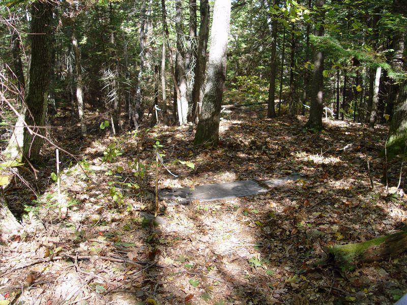
| Description | : | From the notes of Esther Skolfield Schmidt in the Pejepscot Historical Society: "...small cemetery on a bank near a marsh on a chicken farm on road from Mere Point Road to Dyers Corner before World War II." This property is now part of the Brunswick Naval Air Station. There is one headstone with two names in a wooded area. Access is by permission and with escort of the Brunswick Naval Air Station. |
frequently asked questions (FAQ):
-
Where is Skolfield-Doyle Cemetery?
Skolfield-Doyle Cemetery is located at Brunswick, Cumberland County ,Maine ,USA.
-
Skolfield-Doyle Cemetery cemetery's updated grave count on graveviews.com?
0 memorials
-
Where are the coordinates of the Skolfield-Doyle Cemetery?
Latitude: 43.8731200
Longitude: -69.9364300
Nearby Cemetories:
1. Gatchell Cemetery
Cumberland County, USA
Coordinate: 43.8819008, -69.9238968
2. New Meadows Cemetery
Brunswick, Cumberland County, USA
Coordinate: 43.8866997, -69.9238968
3. First Parish Cemetery
Brunswick, Cumberland County, USA
Coordinate: 43.8932991, -69.9732971
4. Maquoit Cemetery
Brunswick, Cumberland County, USA
Coordinate: 43.8839798, -69.9819870
5. Saint John the Baptist Catholic Cemetery
Brunswick, Cumberland County, USA
Coordinate: 43.9077988, -69.9483032
6. Varney Cemetery
Brunswick, Cumberland County, USA
Coordinate: 43.9075012, -69.9505997
7. Pine Grove Cemetery
Brunswick, Cumberland County, USA
Coordinate: 43.9089012, -69.9582977
8. Adams-Hinkley Cemetery
Brunswick, Cumberland County, USA
Coordinate: 43.9015060, -69.8886560
9. Marsh Cemetery
Brunswick, Cumberland County, USA
Coordinate: 43.9015380, -69.8886040
10. Cranberry Horn Cemetery
East Harpswell, Cumberland County, USA
Coordinate: 43.8367004, -69.8989029
11. Harding Cemetery
Brunswick, Cumberland County, USA
Coordinate: 43.9121200, -69.8927000
12. Riverside Cemetery
Brunswick, Cumberland County, USA
Coordinate: 43.9138985, -69.9816971
13. Growstown Cemetery
Brunswick, Cumberland County, USA
Coordinate: 43.8959300, -70.0018600
14. James Dunning Cemetery
Harpswell, Cumberland County, USA
Coordinate: 43.8222500, -69.9627800
15. Riverview Cemetery
Topsham, Sagadahoc County, USA
Coordinate: 43.9264280, -69.9584700
16. Mid Coast Presbyterian Church Columbarium
Topsham, Sagadahoc County, USA
Coordinate: 43.9318150, -69.9653780
17. Orchard Hill Cemetery
West Bath, Sagadahoc County, USA
Coordinate: 43.9107860, -69.8619530
18. Eaton Cemetery
Topsham, Sagadahoc County, USA
Coordinate: 43.9294000, -69.9871800
19. Haley Cemetery
Topsham, Sagadahoc County, USA
Coordinate: 43.9312230, -69.9884460
20. Lemont Cemetery
West Bath, Sagadahoc County, USA
Coordinate: 43.9193500, -69.8621250
21. Hartwell Little Cemetery
Brunswick, Cumberland County, USA
Coordinate: 43.9282830, -69.9999260
22. White Cemetery
West Bath, Sagadahoc County, USA
Coordinate: 43.9223940, -69.8616960
23. First Parish Cemetery
Topsham, Sagadahoc County, USA
Coordinate: 43.9465080, -69.9278710
24. Lombard Cemetery
West Bath, Sagadahoc County, USA
Coordinate: 43.8975210, -69.8398730