
| Memorials | : | 0 |
| Location | : | Currie, Murray County, USA |
| Coordinate | : | 44.0856700, -95.6188600 |
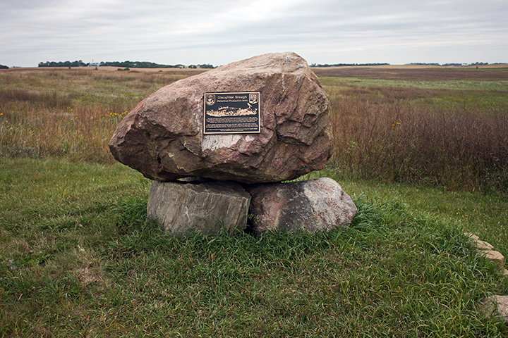
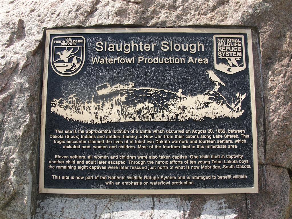
| Description | : | The Slaughter Slough Monument was erected on historic slough grounds maintained by the U. S. Fish and Wildlife Service. The site is the location where settlers from Lake Shetek fled when they were attacked by 100 hostile Dakota Indians on August 20, 1862. Chiefs Lean Bear and White Lodge led the attack. The settlers had attempted to negotiate with Pawn, a Dakota who often lived at Shetek, for their release. They were allowed to leave in a single wagon driven by a team of horses and headed east to go to New Ulm. They had only traveled about 3 miles when... Read More |
frequently asked questions (FAQ):
-
Where is Slaughter Slough Monument?
Slaughter Slough Monument is located at Currie, Murray County ,Minnesota ,USA.
-
Slaughter Slough Monument cemetery's updated grave count on graveviews.com?
0 memorials
-
Where are the coordinates of the Slaughter Slough Monument?
Latitude: 44.0856700
Longitude: -95.6188600
Nearby Cemetories:
1. Calvary Cemetery
Currie, Murray County, USA
Coordinate: 44.0672720, -95.6665240
2. Willow Lake Lutheran Cemetery
Murray County, USA
Coordinate: 44.1235160, -95.6028560
3. Pioneer Cemetery
Currie, Murray County, USA
Coordinate: 44.0733930, -95.6785300
4. Lake Shetek State Monument
Currie, Murray County, USA
Coordinate: 44.0986050, -95.6907840
5. Our Saviors Cemetery
Dovray, Murray County, USA
Coordinate: 44.0505981, -95.5543976
6. Pleasant View Cemetery
Dovray, Murray County, USA
Coordinate: 44.0517270, -95.5523720
7. Bethany Cemetery
Murray County, USA
Coordinate: 44.1142006, -95.7328033
8. Lake Sarah Baptist Cemetery
Murray County, USA
Coordinate: 44.1237670, -95.7404030
9. Modum Cemetery
Murray County, USA
Coordinate: 44.1241989, -95.7514038
10. Emmanuel Cemetery
Avoca, Murray County, USA
Coordinate: 43.9716988, -95.6825027
11. Slayton Cemetery
Slayton, Murray County, USA
Coordinate: 44.0024986, -95.7525024
12. Tracy Community Cemetery
Tracy, Lyon County, USA
Coordinate: 44.2127991, -95.6117020
13. Saint Anne's Cemetery
Murray County, USA
Coordinate: 43.9935751, -95.7441793
14. Slayton Memorial Gardens
Slayton, Murray County, USA
Coordinate: 43.9775009, -95.7322006
15. Hoiland Lutheran Cemetery
Garvin, Lyon County, USA
Coordinate: 44.2106018, -95.7042007
16. Saint Olaf Lutheran Cemetery
Cottonwood County, USA
Coordinate: 44.1478330, -95.4429750
17. Rialson Cemetery
Tracy, Lyon County, USA
Coordinate: 44.2243996, -95.6532974
18. Faith Lutheran Cemetery
Avoca, Murray County, USA
Coordinate: 43.9463997, -95.6594009
19. Saint Rose Cemetery
Avoca, Murray County, USA
Coordinate: 43.9455986, -95.6594009
20. Westbrook Cemetery
Westbrook, Cottonwood County, USA
Coordinate: 44.0503616, -95.4126663
21. Rupp Cemetery
Dovray, Murray County, USA
Coordinate: 43.9784525, -95.4638630
22. Faith Swedish Cemetery
Avoca, Murray County, USA
Coordinate: 43.9366989, -95.6781006
23. Walnut Grove Cemetery
Walnut Grove, Redwood County, USA
Coordinate: 44.2174988, -95.4918976
24. New Home Mennonite Cemetery
Westbrook, Cottonwood County, USA
Coordinate: 43.9881210, -95.4393480