
| Memorials | : | 0 |
| Location | : | Oslo, Oslo kommune, Norway |
| Coordinate | : | 59.1135500, 11.4002833 |
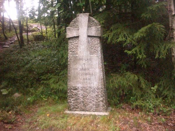
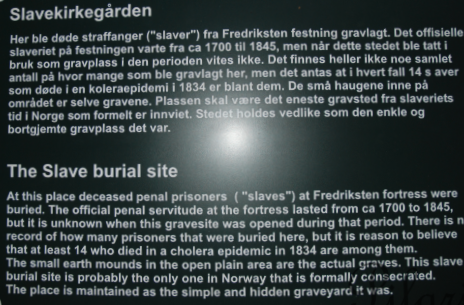
| Description | : | Fredriksten slave cemetery ("Slavekirkegården") is signposted 0.5km from the main road on the same post that also points to Fredriksten camping, but in the opposite direction. However, the road is very narrow and has no parking, so it is best to park at the fortress somewhere (eg N59° 06.956 E11° 23.896 by a cafe) and go by foot or cycle. The cache is located on the periphery of the cemetery. The area is very little advertised and little known, even to some of the staff who work at the fortress. However, if you follow the correct turning (at N59° 06.813 E11°... Read More |
frequently asked questions (FAQ):
-
Where is Slavekirkegården?
Slavekirkegården is located at Oslo, Oslo kommune ,Oslo fylke ,Norway.
-
Slavekirkegården cemetery's updated grave count on graveviews.com?
0 memorials
-
Where are the coordinates of the Slavekirkegården?
Latitude: 59.1135500
Longitude: 11.4002833
Nearby Cemetories:
1. Os gravlund
Halden, Halden kommune, Norway
Coordinate: 59.1284500, 11.3903300
2. Solli gravlund
Halden kommune, Norway
Coordinate: 59.0954910, 11.4430320
3. Idd kirke
Halden kommune, Norway
Coordinate: 59.0862840, 11.4346680
4. Asak kirkegård
Asak, Halden kommune, Norway
Coordinate: 59.1440900, 11.4541500
5. Berg Church
Halden, Halden kommune, Norway
Coordinate: 59.1379563, 11.3292295
6. Hogdal kyrkogård
Hogdal, Strömstads kommun, Sweden
Coordinate: 59.0260830, 11.2301720
7. Skjeberg Cemetery
Skjeberg, Sarpsborg kommune, Norway
Coordinate: 59.2293300, 11.1886000
8. Holmegil Cemetery
Aremark kommune, Norway
Coordinate: 59.1427860, 11.7411870
9. Aremark kirkegård
Fossby, Aremark kommune, Norway
Coordinate: 59.2447300, 11.6818600
10. Hafslund Cemetery
Sarpsborg, Sarpsborg kommune, Norway
Coordinate: 59.2726380, 11.1391310
11. Strömstad kyrkogård
Strömstad, Strömstads kommun, Sweden
Coordinate: 58.9382520, 11.1750700
12. Myren
Strömstad, Strömstads kommun, Sweden
Coordinate: 58.9329880, 11.1835560
13. Borge Gravlund
Sellebakk, Fredrikstad kommune, Norway
Coordinate: 59.2237800, 11.0367300
14. Solli Cemetery
Sarpsborg kommune, Norway
Coordinate: 59.2814800, 11.1116700
15. St. Olav Cemetery
Sarpsborg, Sarpsborg kommune, Norway
Coordinate: 59.2863310, 11.1059850
16. Krigskirkegården
Fredrikstad, Fredrikstad kommune, Norway
Coordinate: 59.1989840, 10.9667020
17. Tune Cemetery
Sarpsborg, Sarpsborg kommune, Norway
Coordinate: 59.2912240, 11.0825020
18. Østre Gravlund
Fredrikstad, Fredrikstad kommune, Norway
Coordinate: 59.2027890, 10.9617930
19. Ostre Fredrikstad Kirke
Fredrikstad kommune, Norway
Coordinate: 59.2023462, 10.9524140
20. Rolvsøy Cemetery
Rolvsøy, Fredrikstad kommune, Norway
Coordinate: 59.2657490, 11.0172410
21. Kråkerøy kirkegård
Kråkerøy, Fredrikstad kommune, Norway
Coordinate: 59.1804580, 10.9289930
22. Gamle Glemmen kirkegård
Fredrikstad, Fredrikstad kommune, Norway
Coordinate: 59.2376710, 10.9711795
23. Leie gravlund
Fredrikstad, Fredrikstad kommune, Norway
Coordinate: 59.2272843, 10.9578962
24. Glemmen kirkegård
Fredrikstad, Fredrikstad kommune, Norway
Coordinate: 59.2156812, 10.9387827