
| Memorials | : | 46 |
| Location | : | Floyd, Floyd County, USA |
| Coordinate | : | 36.8872319, -80.3260720 |
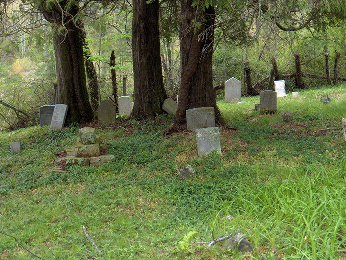
| Description | : | AKA The Lily Patch Many graves are marked with rocks with no inscriptions. The wording on several stones is illegible. Last known burial was 1954. Directions: From Floyd, VA: From the intersection of Main St. (Hwy. 221) in Floyd, turn south on to Rte. 8 (S. Locust St. in Floyd) this will be Parkway Ln. S. Travel 2.3 mi. gravel drive will be on the right, just as you pass a farm on the left. From Blue Ridge Pkwy. Travel north on Parkway Ln. S. 3.7 mi. drive will be on left, cemetery is at top of the... Read More |
frequently asked questions (FAQ):
-
Where is Smith Cemetery?
Smith Cemetery is located at Parkway Lane S (Rt. 8) Floyd, Floyd County ,Virginia , 24091USA.
-
Smith Cemetery cemetery's updated grave count on graveviews.com?
46 memorials
-
Where are the coordinates of the Smith Cemetery?
Latitude: 36.8872319
Longitude: -80.3260720


Nearby Cemetories:
1. Epperly-Ballinger Cemetery
Floyd, Floyd County, USA
Coordinate: 36.8760030, -80.3349010
2. Howell Cemetery
Floyd County, USA
Coordinate: 36.8795445, -80.3459129
3. Howell - Carter Cemetery
Shelors Mill, Floyd County, USA
Coordinate: 36.8752509, -80.3457628
4. Jacksonville Cemetery
Floyd, Floyd County, USA
Coordinate: 36.9063988, -80.3186035
5. Agnew Cemetery
Floyd, Floyd County, USA
Coordinate: 36.8926340, -80.3012620
6. Agnew - Kitterman Cemetery
Floyd, Floyd County, USA
Coordinate: 36.8675980, -80.3171400
7. Howell-Slusher Cemetery
Floyd, Floyd County, USA
Coordinate: 36.8653903, -80.3308104
8. Bolen Cemetery
Floyd, Floyd County, USA
Coordinate: 36.8709370, -80.3468100
9. Floyd Cemetery
Floyd, Floyd County, USA
Coordinate: 36.9102860, -80.3188110
10. Howell-Via Cemetery
Floyd, Floyd County, USA
Coordinate: 36.8776040, -80.3533390
11. Benjamin Dodd Cemetery
Floyd, Floyd County, USA
Coordinate: 36.9068870, -80.3470830
12. Col. Jacob Helms Cemetery
Floyd, Floyd County, USA
Coordinate: 36.9007300, -80.3558900
13. East Hill Cemetery
Floyd, Floyd County, USA
Coordinate: 36.8562800, -80.3272450
14. Joel Agnew Cemetery
Floyd, Floyd County, USA
Coordinate: 36.8649390, -80.2988530
15. O’Bryan - Cannaday Cemetery
Floyd, Floyd County, USA
Coordinate: 36.8563093, -80.3145326
16. Big Oak Cemetery
Floyd, Floyd County, USA
Coordinate: 36.9175685, -80.3073990
17. Burgess Cemetery
Floyd, Floyd County, USA
Coordinate: 36.8528090, -80.3411270
18. Oliver Perry Slusher Cemetery
Laurel Branch, Floyd County, USA
Coordinate: 36.9167900, -80.3587400
19. Akers - Turman Cemetery
Floyd, Floyd County, USA
Coordinate: 36.9128690, -80.3653230
20. Thomas Grove Cemetery
Floyd, Floyd County, USA
Coordinate: 36.8608892, -80.2866001
21. Haynes Family Cemetery - Tuggles Gap
Floyd, Floyd County, USA
Coordinate: 36.8904336, -80.2740650
22. Harter Farm Cemetery
Floyd, Floyd County, USA
Coordinate: 36.8441730, -80.3374180
23. Jacob Slusher Cemetery
Laurel Branch, Floyd County, USA
Coordinate: 36.9163236, -80.3682087
24. Lee Cemetery
Floyd, Floyd County, USA
Coordinate: 36.8745460, -80.2723090