
| Memorials | : | 0 |
| Location | : | Weston, Lewis County, USA |
| Coordinate | : | 39.0463070, -80.4173810 |
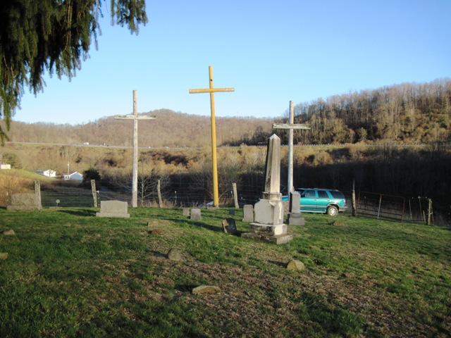
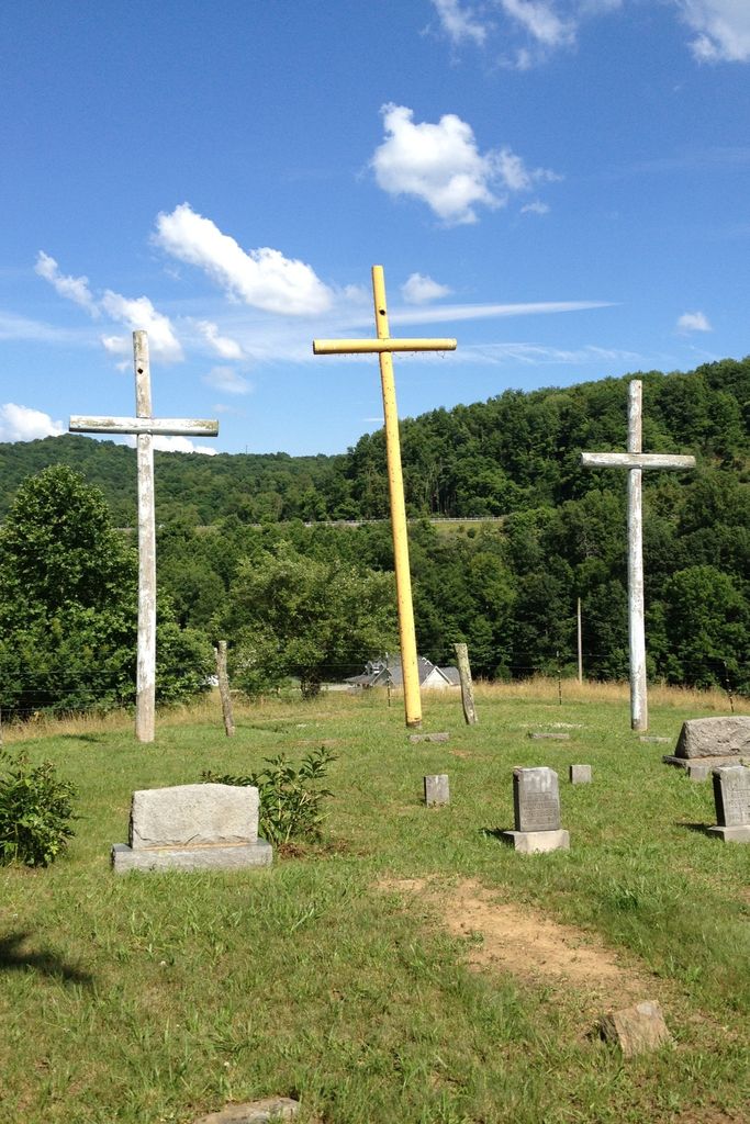
| Description | : | Smiths Run Cemetery (aka Smith’s Run Cemtery, Smith Run Church Cemetery, or Martin Smith Cemetery) is north-northeast of Smith Run Road (Lewis County RT 14) about 1.9 miles from US RT 33 at Weston WV. As you approach the cemetery vicinity, you see three large wooden crosses on the cemetery knoll overlooking the road. The entrance is at LAT 39.045761 LONG -80.417696 as a gravel road off Smith Run Road. There is limited parking at the entrance. Access is then by a walk up the steep gravel road about 600 feet to the cemetery gate on... Read More |
frequently asked questions (FAQ):
-
Where is Smiths Run Cemetery?
Smiths Run Cemetery is located at Smith Run Road (County RT 14) Weston, Lewis County ,West Virginia , 26452USA.
-
Smiths Run Cemetery cemetery's updated grave count on graveviews.com?
0 memorials
-
Where are the coordinates of the Smiths Run Cemetery?
Latitude: 39.0463070
Longitude: -80.4173810
Nearby Cemetories:
1. Smith Family Cemetery
Lewis County, USA
Coordinate: 39.0457993, -80.4297028
2. Forest Lawn Memorial Gardens
Jane Lew, Lewis County, USA
Coordinate: 39.0649986, -80.4328003
3. Lewis County Memorial Gardens
Weston, Lewis County, USA
Coordinate: 39.0224390, -80.4202340
4. Peterson Cemetery
Weston, Lewis County, USA
Coordinate: 39.0224991, -80.4244003
5. Hicks Cemetery
Lewis County, USA
Coordinate: 39.0717010, -80.4077988
6. Bush Cemetery
Horner, Lewis County, USA
Coordinate: 39.0147018, -80.4021988
7. Machpelah Cemetery
Weston, Lewis County, USA
Coordinate: 39.0475400, -80.4640760
8. Old Arnold Cemetery
Weston, Lewis County, USA
Coordinate: 39.0350120, -80.4693550
9. Friendship Cemetery
Berlin, Lewis County, USA
Coordinate: 39.0760994, -80.3794022
10. Butcher Cemetery
Turnertown, Lewis County, USA
Coordinate: 39.0727997, -80.4614029
11. Weston State Hospital Cemetery
Weston, Lewis County, USA
Coordinate: 39.0395050, -80.4727760
12. Laurel Lick Cemetery
Lewis County, USA
Coordinate: 39.0386009, -80.3617020
13. Morrison Cemetery
Berlin, Lewis County, USA
Coordinate: 39.0633100, -80.3648120
14. Thomas Law Cemetery
Jane Lew, Lewis County, USA
Coordinate: 39.0893270, -80.4326240
15. Horner Methodist Church Cemetery
Weston, Lewis County, USA
Coordinate: 39.0041069, -80.3845373
16. Brownsville Cemetery
Lewis County, USA
Coordinate: 39.0163994, -80.4756012
17. Straley Cemetery
Jane Lew, Lewis County, USA
Coordinate: 39.0990820, -80.3941210
18. Gee Lick Cemetery
Weston, Lewis County, USA
Coordinate: 39.0787170, -80.4761610
19. Harmony Cemetery
Jane Lew, Lewis County, USA
Coordinate: 39.0999985, -80.3899994
20. Dutch Hollow Road Cemetery
Lewis County, USA
Coordinate: 39.0730330, -80.4860520
21. Mount Hebron Cemetery
Jane Lew, Lewis County, USA
Coordinate: 39.1060982, -80.4255981
22. Pioneer Cemetery
Jane Lew, Lewis County, USA
Coordinate: 39.1071830, -80.4098780
23. Jesse Run Cemetery
Jane Lew, Lewis County, USA
Coordinate: 39.1038235, -80.3900664
24. Glady Cemetery
Horner, Lewis County, USA
Coordinate: 38.9846992, -80.4389038