
| Memorials | : | 0 |
| Location | : | Risor, Risør kommune, Norway |
| Coordinate | : | 58.7631660, 9.0797640 |
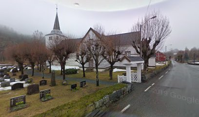
| Description | : | Sondeled Churchyard is at Indre Sondeled, a town on the E18 halfway between Arendal and Brevik. From the E18, turn off to Indre Sondeled. In the town, follow the direction to Hasasmyr and follow this road to the T-junction and turn left. The church is along this road. The collective Commonwealth war grave is located at the far end of the main path. Historical Information: During the Second World War, Norway was of strategic importance to the Germans. Their invasion on 9 April 1940 was sudden and widespread and despite Allied intervention, the entire country was under German occupation by... Read More |
frequently asked questions (FAQ):
-
Where is Søndeled Churchyard?
Søndeled Churchyard is located at Risor, Risør kommune ,Aust-Agder fylke ,Norway.
-
Søndeled Churchyard cemetery's updated grave count on graveviews.com?
0 memorials
-
Where are the coordinates of the Søndeled Churchyard?
Latitude: 58.7631660
Longitude: 9.0797640
Nearby Cemetories:
1. Sandnes Cemetery
Risor, Risør kommune, Norway
Coordinate: 58.6908480, 9.1555290
2. Risor Civil Cemetery
Risor, Risør kommune, Norway
Coordinate: 58.7194180, 9.2252150
3. Kilen
Kviteseid kommune, Norway
Coordinate: 58.6719440, 9.1644440
4. Dypvåg Kirke Cemetery
Dypvag, Tvedestrand kommune, Norway
Coordinate: 58.6264853, 9.0522182
5. Sannidal Kirkegård
Sannidal, Kragerø kommune, Norway
Coordinate: 58.8930850, 9.2661050
6. Støle Gravlund
Stole, Kragerø kommune, Norway
Coordinate: 58.8224070, 9.3733250
7. Ospevika Cemetery
Levang, Kragerø kommune, Norway
Coordinate: 58.8002740, 9.3989320
8. Kroken Cemetery
Drangedal, Drangedal kommune, Norway
Coordinate: 58.9446620, 9.1326920
9. Holt Cemetery
Tvedestrand, Tvedestrand kommune, Norway
Coordinate: 58.6070000, 8.8700000
10. Kragerø Cemetery
Kragero, Kragerø kommune, Norway
Coordinate: 58.8725250, 9.3823020
11. Skåtøy/Kalstad Cemetery
Kragero, Kragerø kommune, Norway
Coordinate: 58.8734876, 9.3844441
12. Felle Cemetery
Felle, Nissedal kommune, Norway
Coordinate: 58.9027290, 8.7495320
13. Skaatøy Cemetery
Skatoy, Kragerø kommune, Norway
Coordinate: 58.8596990, 9.4759960
14. Austre Moland Cemetery
Arendal, Arendal kommune, Norway
Coordinate: 58.5464000, 8.8112000
15. Langøy Cemetery
Kragero, Kragerø kommune, Norway
Coordinate: 58.9099540, 9.4990780
16. Jysereid
Drangedal, Drangedal kommune, Norway
Coordinate: 59.0304470, 8.9544920
17. Rørholt Cemetery
Rorholt, Bamble kommune, Norway
Coordinate: 59.0015780, 9.3780300
18. Helleheia
Arendal, Arendal kommune, Norway
Coordinate: 58.5062620, 8.8392710
19. Stokken kirkegård
Salterod, Arendal kommune, Norway
Coordinate: 58.4920122, 8.8440023
20. Aamli Cemetery
Amli, Åmli kommune, Norway
Coordinate: 58.7673700, 8.4879600
21. Froland Cemetery
Froland kommune, Norway
Coordinate: 58.5265570, 8.6515620
22. Tromøy Cemetery
Arendal, Arendal kommune, Norway
Coordinate: 58.4498201, 8.8644122
23. Drangedal Kirke Cemetery
Drangedal, Drangedal kommune, Norway
Coordinate: 59.0995930, 9.0638710
24. Barbu Kirkegaard
Arendal, Arendal kommune, Norway
Coordinate: 58.4642787, 8.7753218