
| Memorials | : | 0 |
| Location | : | Belize |
| Coordinate | : | 17.1417040, -88.8029350 |
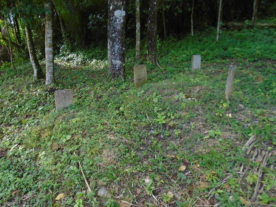
| Description | : | The Springfield Mennonite Cemetery is located in a patch of trees behind the church building. In 2018, there were only three burials in the cemetery. The Springfield Mennonite Community is located on a crossroad off the Hummingbird highway that connects Belmopan, the capital of Belize, with the town of Dangriga, on the Caribbean coast. The road leading to the colony is unpaved and bumpy, and difficult to navigate in the rainy season. After passing through Springfield it stops abruptly at the last farm, at the edge of the jungle. Springfield is a small settlement, founded in response to a land shortage... Read More |
frequently asked questions (FAQ):
-
Where is Springfield Mennonite Cemetery?
Springfield Mennonite Cemetery is located at Cayo ,Belize.
-
Springfield Mennonite Cemetery cemetery's updated grave count on graveviews.com?
0 memorials
-
Where are the coordinates of the Springfield Mennonite Cemetery?
Latitude: 17.1417040
Longitude: -88.8029350
Nearby Cemetories:
1. Independence Village Cemetery
Belize
Coordinate: 16.5362000, -88.4216000
2. Camp 3 Shipyard
Belize
Coordinate: 17.9310410, -88.6399500
3. Camp 4 Shipyard
Belize
Coordinate: 17.9406370, -88.6651920
4. Panteón de Ley de Fomento A. (La Misteriosa)
Ley de Fomento Agropecuario (La Misteriosa), Calakmul Municipality, Mexico
Coordinate: 18.0620401, -89.4232560
5. Panteón de San Miguel
San Miguel, Calakmul Municipality, Mexico
Coordinate: 18.0920082, -89.4328905
6. Panteón Municipal de Álvaro Obregón
Alvaro Obregon, Othón P. Blanco Municipality, Mexico
Coordinate: 18.2967150, -88.6265440
7. Panteón de Niños Héroes
Ninos Heroes, Calakmul Municipality, Mexico
Coordinate: 18.1536078, -89.4626413
8. Cementerio Municipal de Livingston
Livingston, Municipio de Livingston, Guatemala
Coordinate: 15.8298221, -88.7559251
9. Panteón de Ing. Ricardo Payro Jene
Ingeniero Ricardo Payro Jene (Polo Norte), Calakmul Municipality, Mexico
Coordinate: 18.3128540, -89.4446341
10. Panteón de la Comunidad de Nicolás Bravo
Nicolas Bravo, Othón P. Blanco Municipality, Mexico
Coordinate: 18.4587261, -88.9416417
11. Panteón
Ingeniero Ricardo Payro Jene (Polo Norte), Calakmul Municipality, Mexico
Coordinate: 18.3306521, -89.4778877
12. Panteón de Manuel Castilla Brito
Manuel Castilla Brito, Calakmul Municipality, Mexico
Coordinate: 18.3580577, -89.4441094
13. Panteón de Santa Elena
Santa Elena, José María Morelos Municipality, Mexico
Coordinate: 18.4964290, -88.3975150
14. Monumento al Vicealmirante Othón P. Blanco
Chetumal, Othón P. Blanco Municipality, Mexico
Coordinate: 18.4934076, -88.2979945
15. Panteón Civil Municipal de Chetumal
Chetumal, Othón P. Blanco Municipality, Mexico
Coordinate: 18.5025530, -88.3037080
16. Cementerio General
Puerto Barrios, Municipio de Puerto Barrios, Guatemala
Coordinate: 15.7127000, -88.5907000
17. Cementerio Campos del Recuerdo
Chetumal, Othón P. Blanco Municipality, Mexico
Coordinate: 18.5333130, -88.3129510
18. Panteón Municipal de Xpujil
Xpujil, Calakmul Municipality, Mexico
Coordinate: 18.5088199, -89.3915644
19. Panteón Municipal de Calderitas
Calderitas, Othón P. Blanco Municipality, Mexico
Coordinate: 18.5566590, -88.2561820
20. Panteón del Eterno Descanso
Bacalar, Bacalar Municipality, Mexico
Coordinate: 18.6769230, -88.3951170
21. Cementerio General de Morales
Municipio de Morales, Guatemala
Coordinate: 15.4730704, -88.8319963
22. Cementerio General San Pedro Apóstol
San Pedro Sula, Municipio de San Pedro Sula, Honduras
Coordinate: 15.4964494, -88.0274100
23. Tela New Cemetery
Tela, Municipio de Tela, Honduras
Coordinate: 15.7795300, -87.4693500
24. La Esperanza Cemetery
Tela, Municipio de Tela, Honduras
Coordinate: 15.7843246, -87.4443054