
| Memorials | : | 0 |
| Location | : | Plymouth, Plymouth Unitary Authority, England |
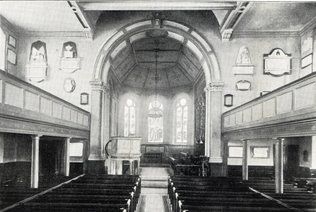
| Description | : | Although it started as a chapel-of-ease to Saint Andrew's Church in Plymouth, it eventually became the parish church of East Stonehouse. The church was badly damaged in World War II by German bombers. The graves were removed to Efford Cemetery but the tombstones and monuments were reported as to be 'broken and dispersed'. The site was turned over to industrial use in 1959. Maps on Know Your Place show the church and graveyard have had the Council House and Civic Centre built on the site. |
frequently asked questions (FAQ):
-
Where is St George of Lydda ( Demolished )?
St George of Lydda ( Demolished ) is located at Plymouth, Plymouth Unitary Authority, England.
-
St George of Lydda ( Demolished ) cemetery's updated grave count on graveviews.com?
0 memorials

Nearby Cemetories:
1. St John's Cemetery
Hooe, Plymouth Unitary Authority, England
Coordinate: 50.4100000, -4.1000000
2. Howard Road Dissenters Cemetery
Plymstock, Plymouth Unitary Authority, England
Coordinate: 50.3752530, -4.0686940
3. Ridge Cross Cemetery
Plymstock, Plymouth Unitary Authority, England
Coordinate: 50.3827880, -4.0396640
4. St Mary and All Saints Churchyard
Plymstock, Plymouth Unitary Authority, England
Coordinate: 50.3881800, -4.0595100
5. Milehouse Cemetery
Devonport, Plymouth Unitary Authority, England
Coordinate: 50.3838900, -4.0468100
6. Plymouth Royal Naval Hospital Burial Ground
Devonport, Plymouth Unitary Authority, England
Coordinate: 50.3839800, -4.0460000
7. Saint Andrew Churchyard
Devonport, Plymouth Unitary Authority, England
8. St. Andrew with St. Luke Churchyard
Devonport, Plymouth Unitary Authority, England
Coordinate: 50.3608000, -4.1080700
9. St. Pancras Church Cemetery
Pennycross, Plymouth Unitary Authority, England
10. St. Pancras Churchyard
Pennycross, Plymouth Unitary Authority, England
Coordinate: 50.4130353, -4.1769516
11. St Mary's Church
Tamerton Foliot, Plymouth Unitary Authority, England
Coordinate: 50.4007100, -4.1146830
12. Clare House Conventual Cemetery
Coxside, Plymouth Unitary Authority, England
13. Estover
Estover, Plymouth Unitary Authority, England
Coordinate: 50.4100000, -4.1000000
14. Drake Memorial Park
Plympton, Plymouth Unitary Authority, England
Coordinate: 50.3752530, -4.0686940
15. Longcause Cemetery
Plympton, Plymouth Unitary Authority, England
Coordinate: 50.3827880, -4.0396640
16. St Mary Blessed Virgin Churchyard
Plympton, Plymouth Unitary Authority, England
Coordinate: 50.3881800, -4.0595100
17. St Maurice Churchyard
Plympton, Plymouth Unitary Authority, England
Coordinate: 50.3838900, -4.0468100
18. St. Maurice Nonconformist Burial Ground
Plympton, Plymouth Unitary Authority, England
Coordinate: 50.3839800, -4.0460000
19. Lee Moor Chapel
Plymouth Unitary Authority, England
20. Oreston Methodist Church Burial Ground
Oreston, Plymouth Unitary Authority, England
Coordinate: 50.3608000, -4.1080700
21. St Budiana Churchyard
St Budeaux, Plymouth Unitary Authority, England
22. St Budoc Churchyard
St Budeaux, Plymouth Unitary Authority, England
Coordinate: 50.4130353, -4.1769516
23. St. Edward's Churchyard
Eggbuckland, Plymouth Unitary Authority, England
Coordinate: 50.4007100, -4.1146830
24. Cathedral Church of St. Mary and St. Boniface Churchyard
Stonehouse, Plymouth Unitary Authority, England