
| Memorials | : | 0 |
| Location | : | Chesterton, Stratford-on-Avon District, England |
| Coordinate | : | 52.2235680, -1.4817280 |
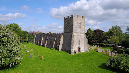
| Description | : | The Church was founded by Richard the Forester in the 11th Century and presented in Richard II's time to the Barons of Kenilworth, by William Croc. It later came under the Abbots of Worcester, but by 1693 was under the Cathedral Church of Lichfield. |
frequently asked questions (FAQ):
-
Where is St. Giles Church - Chesterton?
St. Giles Church - Chesterton is located at Chesterton, Stratford-on-Avon District ,Warwickshire ,England.
-
St. Giles Church - Chesterton cemetery's updated grave count on graveviews.com?
0 memorials
-
Where are the coordinates of the St. Giles Church - Chesterton?
Latitude: 52.2235680
Longitude: -1.4817280
Nearby Cemetories:
1. Harbury Cemetery
Harbury, Stratford-on-Avon District, England
Coordinate: 52.2353200, -1.4574100
2. Harbury Wesleyan Chapel Graveyard
Harbury, Stratford-on-Avon District, England
Coordinate: 52.2362020, -1.4566560
3. All Saints Churchyard
Harbury, Stratford-on-Avon District, England
Coordinate: 52.2368240, -1.4530070
4. Bishop's Itchington Cemetery
Bishops Itchington, Stratford-on-Avon District, England
Coordinate: 52.2235460, -1.4322530
5. St Michaels Churchyard
Bishops Itchington, Stratford-on-Avon District, England
Coordinate: 52.2161900, -1.4332260
6. St Michael's
Ufton, Stratford-on-Avon District, England
Coordinate: 52.2564270, -1.4465990
7. St. Giles Churchyard
Gaydon, Stratford-on-Avon District, England
Coordinate: 52.1825900, -1.4683490
8. St Chad's Churchyard
Bishops Tachbrook, Warwick District, England
Coordinate: 52.2496300, -1.5420000
9. Gaydon Cemetery
Gaydon, Stratford-on-Avon District, England
Coordinate: 52.1796880, -1.4632870
10. Holy Cross Churchyard
Moreton Morrell, Stratford-on-Avon District, England
Coordinate: 52.1979350, -1.5468100
11. Oakley Wood Crematorium
Bishops Tachbrook, Warwick District, England
Coordinate: 52.2331650, -1.5598750
12. All Saints Churchyard
Chadshunt, Stratford-on-Avon District, England
Coordinate: 52.1743200, -1.4906810
13. St George the Martyr Churchyard
Newbold Pacey, Stratford-on-Avon District, England
Coordinate: 52.2117630, -1.5637170
14. Whitnash Cemetery Extension
Whitnash, Warwick District, England
Coordinate: 52.2707300, -1.5181000
15. All Saints Churchyard
Ladbroke, Stratford-on-Avon District, England
Coordinate: 52.2267360, -1.3960660
16. St Margarets Churchyard
Whitnash, Warwick District, England
Coordinate: 52.2706380, -1.5206680
17. St Nicholas' Churchyard
Radford Semele, Warwick District, England
Coordinate: 52.2799730, -1.4986880
18. Leamington Cemetery
Leamington Spa, Warwick District, England
Coordinate: 52.2756400, -1.5282700
19. St John the Baptist
Leamington Spa, Warwick District, England
Coordinate: 52.2778940, -1.5306560
20. St James Churchyard
Southam, Stratford-on-Avon District, England
Coordinate: 52.2525240, -1.3893000
21. Compton Verney Chapel Cemetery
Compton Verney, Stratford-on-Avon District, England
Coordinate: 52.1733472, -1.5472472
22. St Laurence Churchyard
Lighthorne, Stratford-on-Avon District, England
Coordinate: 52.1733472, -1.5472472
23. St. Gregory's Churchyard
Leamington Spa, Warwick District, England
Coordinate: 52.2878560, -1.4763950
24. St Mary
Leamington Spa, Warwick District, England
Coordinate: 52.2836150, -1.5216220